
Hudson Bay, sometimes called Hudson's Bay, is a large body of saltwater in northeastern Canada with a surface area of 1,230,000 km2 (470,000 sq mi). It is located north of Ontario, west of Quebec, northeast of Manitoba, and southeast of Nunavut, but politically entirely part of Nunavut. It is an inland marginal sea of the Arctic Ocean. The Hudson Strait provides a connection between the Labrador Sea and the Atlantic Ocean in the northeast, while the Foxe Channel connects the Hudson Bay with the Arctic Ocean in the north. The Hudson Bay drainage basin drains a very large area, about 3,861,400 km2 (1,490,900 sq mi), that includes parts of southeastern Nunavut, Alberta, Saskatchewan, Ontario, Quebec, all of Manitoba, and parts of the U.S. states of North Dakota, South Dakota, Minnesota, and Montana. Hudson Bay's southern arm is called James Bay.

Baffin Island, in the Canadian territory of Nunavut, is the largest island in Canada, the second largest island in the Americas, and the fifth-largest island in the world. Its area is 507,451 km2 (195,928 sq mi) with a population density of 0.03/km2; the population was 13,039 according to the 2021 Canadian census; and it is located at 68°N70°W. It also contains the city of Iqaluit, which is the capital of Nunavut.

The Continental Divide of the Americas is the principal, and largely mountainous, hydrological divide of the Americas. The Continental Divide extends from the Bering Strait to the Strait of Magellan, and separates the watersheds that drain into the Pacific Ocean from those river systems that drain into the Atlantic and Arctic Ocean, including those that drain into the Gulf of Mexico, the Caribbean Sea, and Hudson Bay.

Baffin Bay, located between Baffin Island and the west coast of Greenland, is defined by the International Hydrographic Organization as a marginal sea of the Arctic Ocean. It is sometimes considered a sea of the North Atlantic Ocean. It is connected to the Atlantic via Davis Strait and the Labrador Sea. The narrower Nares Strait connects Baffin Bay with the Arctic Ocean. The bay is not navigable most of the year because of the ice cover and high density of floating ice and icebergs in the open areas. However, a polynya of about 80,000 km2 (31,000 sq mi), known as the North Water, opens in summer on the north near Smith Sound. Most of the aquatic life of the bay is concentrated near that region.

Arctic Bay is an Inuit hamlet located in the northern part of the Borden Peninsula on Baffin Island in the Qikiqtaaluk Region of Nunavut, Canada. Arctic Bay is located in the Eastern Time Zone although it is quite close to the time zone boundary. The predominant languages are Inuktitut and English. Arctic Bay is notable for being the birthplace of the former Premier of Nunavut and, as of 2021, the Commissioner of Nunavut, Eva Aariak. It is the northernmost public community in Canada not formed from forced relocation.

Axel Heiberg Island is an uninhabited island in the Qikiqtaaluk Region, Nunavut, Canada. Located in the Arctic Ocean, it is the 32nd largest island in the world and Canada's seventh largest island. According to Statistics Canada, it has an area of 43,178 km2 (16,671 sq mi). It is named after Axel Heiberg.
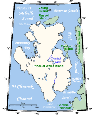
Prince of Wales Island is an Arctic island in Nunavut, Canada. One of the larger members of the Arctic Archipelago, it lies between Victoria Island and Somerset Island and is south of the Queen Elizabeth Islands.

Joseph-René Bellot was a French naval officer and Arctic explorer.

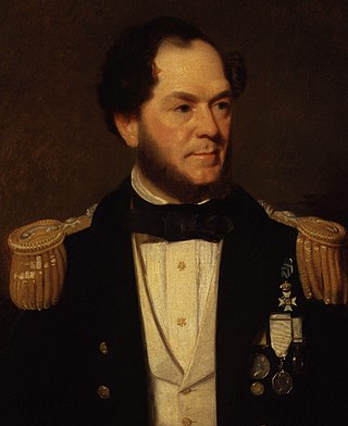
Sir Horatio Thomas Austin was a British Royal Navy officer and explorer.

HMS Terror was a specialised warship and a newly developed bomb vessel constructed for the Royal Navy in 1813. She participated in several battles of the War of 1812, including the Battle of Baltimore with the bombardment of Fort McHenry. She was converted into a polar exploration ship two decades later, and participated in George Back's Arctic expedition of 1836–1837, the successful Ross expedition to the Antarctic of 1839 to 1843, and Sir John Franklin's ill-fated attempt to force the Northwest Passage in 1845, during which she was lost with all hands along with HMS Erebus.

Coronation Island is the largest of the South Orkney Islands, 25 nautical miles (46 km) long and from 3 to 8 nautical miles wide. The island extends in a general east–west direction, is mainly ice-covered and comprises numerous bays, glaciers and peaks, the highest rising to 1,265 metres (4,150 ft).
Hector Glacier is located in Banff National Park, Alberta, Canada. The glacier is on the north slope of Mount Hector and extends northward for 3 km (1.9 mi). In 1938, a large mass of the glacier broke off and covered the valley below with ice up to 60 m (200 ft) thick. The ice mass destroyed everything in its path and this is only the second known glacier hazard to have been recorded in the Canadian Rockies. The glacier, along with Mount Hector and Hector Lake are all named after James Hector, a prominent early naturalist to the region.
Jackson Island is an island located in Franz Josef Land, Arkhangelsk Oblast, Russian Federation. This island is part of the Zichy Land subgroup of the central part of the archipelago.

Franklin's lost expedition was a failed British voyage of Arctic exploration led by Captain Sir John Franklin that departed England in 1845 aboard two ships, HMS Erebus and HMS Terror, and was assigned to traverse the last unnavigated sections of the Northwest Passage in the Canadian Arctic and to record magnetic data to help determine whether a better understanding could aid navigation. The expedition met with disaster after both ships and their crews, a total of 129 officers and men, became icebound in Victoria Strait near King William Island in what is today the Canadian territory of Nunavut. After being icebound for more than a year Erebus and Terror were abandoned in April 1848, by which point two dozen men, including Franklin, had died. The survivors, now led by Franklin's second-in-command, Francis Crozier, and Erebus's captain, James Fitzjames, set out for the Canadian mainland and disappeared, presumably having perished.
M'Clintock Channel is located in the territory of Nunavut, Canada. The channel, an arm of the Arctic Ocean, divides Victoria Island from Prince of Wales Island. This channel is named after Sir Francis McClintock, an Irish explorer in the British Royal Navy, famous for his Canadian Arctic explorations. The channel is 270 km (170 mi) long, and between 105 and 209 km wide, making it one of the largest channels in the Arctic Archipelago.
Sir Erasmus Ommanney was a Royal Navy officer and an Arctic explorer of the Victorian era.
The names Ommanney and Ommaney are English, and may refer to one of the following:
Ommanney Bay is a bay 2 mi (3.2 km) wide between Prong Point and Foul Point on the north coast of Coronation Island, in the South Orkney Islands of Antarctica. Like much of Coronation Island and its surrounding features, it was first seen and roughly charted by Captain George Powell and Captain Nathaniel Palmer in 1821. It was recharted in 1933 by Discovery Investigations personnel on the Discovery II and named for Francis D. Ommanney, zoologist on the staff of the Discovery Committee.
Ommanney is a surname, and may refer to:

Qalaherriaq, baptized as Erasmus Augustine Kallihirua, was an Inughuit hunter from Cape York, Greenland. He was recruited in 1850 as an interpreter by the crew of the British survey barque HMS Assistance during the search for John Franklin's lost Arctic expedition. He guided the ship to Wolstenholme Fjord to investigate rumors of a massacre of Franklin's crew, but only found the corpses of local Inughuit and crew from an unrelated British vessel. He was alleged to have produced an extremely accurate map of his homeland, but was almost certainly aided by the crew of the vessel. Although the Assistance initially planned to return him to his family after the expedition, poor sea conditions made landing at Cape York impossible, and he was taken to England and placed under the care of the Society for Promoting Christian Knowledge (SPCK).
