James Bay is a large body of water located on the southern end of Hudson Bay in Canada. It borders the provinces of Quebec and Ontario, and is politically part of Nunavut. Its largest island is Akimiski Island.

Baffin Island, in the Canadian territory of Nunavut, is the largest island in Canada, the second-largest island in the Americas, and the fifth-largest island in the world. Its area is 507,451 km2 (195,928 sq mi) with a population density of 0.03/km2; the population was 13,039 according to the 2021 Canadian census; and it is located at 68°N70°W. It also contains the city of Iqaluit, which is the capital of Nunavut.

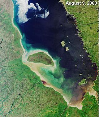
Akimiski Island is the largest island in James Bay, Canada, which is part of the Qikiqtaaluk Region of the territory of Nunavut. It has an area of 3,001 km2 (1,159 sq mi), making it the 163rd largest island in the world, and Canada's 29th largest island. Akimiski Island is 19 km (12 mi) from the province of Ontario. From the western side of the island, the Ontario coastline is visible.

Akpatok Island is one of the uninhabited Canadian Arctic islands in the Qikiqtaaluk Region of Nunavut, Canada. It is the largest island in Ungava Bay on the northern coast of Quebec. The island is named for the akpat, which live on ledges along the limestone cliffs surrounding the island.

Qikiqtaryuaq, formerly Jenny Lind Island, for the Swedish born opera singer, Jenny Lind, is a small island 420 km2 (160 sq mi) in the Kitikmeot Region of Nunavut, Canada. The island is located in the Queen Maud Gulf, about 120 km (75 mi) southeast of Cambridge Bay.
Southern James Bay is a coastal wetland complex in northeastern Ontario, Canada bordering James Bay and Quebec. It was designated as a wetland of international importance via the Ramsar Convention on May 27, 1987. The shallow waters of the James Bay region represent an important late autumn staging area for migratory, Arctic-breeding waterbirds.

Dewey Soper Migratory Bird Sanctuary, or Dewey Soper, is a migratory bird sanctuary in the Qikiqtaaluk Region, Nunavut, Canada. It is located in western Baffin Island, from Bowman Bay to the Koukdjuak River, and is named in honour of zoologist J. Dewey Soper. It is an 8,159 km2 (3,150 sq mi) area that was classified a wetland of international importance via the Ramsar Convention on May 24, 1982. The bird sanctuary supports nearly 30% of the breeding geese in Canada, making it the largest goose colony in the world. Up to two million birds of various species use the area for summer nesting, and it is also "habitat for one of Canada's major barren-ground caribou herds". The sanctuary was established in 1957, and is subject to the Nunavut Land Claims Agreement, which defines and governs ownership, land use and hunting rights in the area.

The Koukdjuak River begins at the outlet of Nettilling Lake and empties into the Arctic Ocean. It is the namesake of the Great Plain of the Koukdjuak located in the Foxe Basin on western Baffin Island, Nunavut, northern Canada.

The Great Plain of the Koukdjuak is located in the Qikiqtaaluk Region, Nunavut within the Canadian Arctic. It is the namesake of the Koukdjuak River in western Baffin Island on the southeastern coast of Foxe Basin. It stretches from Cory Bay to Hantzsch Bay, and then inland.
Baillarge Bay is an Arctic waterway in the Qikiqtaaluk Region, Nunavut, Canada. It is the second waterway to press eastward from Admiralty Inlet into Baffin Island. The southern point of its mouth is named Ship Point.
Cape Pembroke is an uninhabited headland at the northeastern tip of Coats Island in northern Hudson Bay within the Kivalliq Region of Nunavut, Canada.
East Bay is a waterway in the Kivalliq Region, Nunavut, Canada. It is located in Hudson Bay off eastern Southampton Island. Caribou Island lies to the north of the bay's mouth. The nearest community is Coral Harbour, 35 km (22 mi) to the west.
Native Bay is a waterway in the Kivalliq Region, Nunavut, Canada. It is located in Hudson Bay off western Southampton Island. The Bell Peninsula lies to the southeast. Native Point is located at the bay's southern tip. East Bay is 20 km (12 mi) to the east and Coral Harbour is 36 km (22 mi) to the north northwest.
Reid Bay is an Arctic waterway in the Qikiqtaaluk Region, Nunavut, Canada. It is located in Davis Strait off Baffin Island's Cumberland Sound.
Fraser Island is an uninhabited island in the Qikiqtaaluk Region of Nunavut, Canada. It is located at the mouth of Hudson Bay off Nottingham Island's northwestern tip. The closest community is the Inuit hamlet of Kinngait, 120 km (75 mi) to the northeast on Baffin Island.

Baie-Johan-Beetz is a municipality located near the mouth of the Piashti River on the north shore of the Gulf of St. Lawrence, in the Côte-Nord region, Minganie RCM, Quebec, Canada.
The East Bay (Qaqsauqtuuq) Migratory Bird Sanctuary, Qaqsauqtuuq Migratory Bird Sanctuary, or Refuge d'oiseaux de la baie Est is a migratory bird sanctuary in the Kivalliq Region, Nunavut, Canada. It is located in East Bay, an arm of Hudson Bay, in southeast Southampton Island. The nearest community is Coral Harbour, 35 km (22 mi) to the west.
The Boatswain Bay Migratory Bird Sanctuary is a migratory bird sanctuary that extends between Nunavut and Quebec, Canada. It is located in Boatswain Bay an arm of James Bay, and the Quebec headland. It was established on 29 January 1941 and consists of 17,900 hectares It was established in 1941. It is classified Category IV by the International Union for Conservation of Nature.
Bowman Bay is an Arctic waterway in the Qikiqtaaluk Region, Nunavut, Canada. It is located in the Foxe Basin by northeastern Foxe Peninsula off Baffin Island. The nearest community is Kinngait, situated 204 km (127 mi) to the south, while Nuwata, a former settlement, is situated 188 km (117 mi) to the west near Finnie Bay.

Cape Parry is a headland in Canada's Northwest Territories. Located at the northern tip of the Parry Peninsula, it projects into Amundsen Gulf. The nearest settlement is Paulatuk, 100 km (62 mi) to the south, and Fiji Island is located 9 km (5.6 mi) to the west. Cape Parry was formerly accessible through Cape Parry Airport that was located at the Distant Early Warning Line. The airport was listed as abandoned after the closure of the DEW line site.
