This page is based on this
Wikipedia article Text is available under the
CC BY-SA 4.0 license; additional terms may apply.
Images, videos and audio are available under their respective licenses.
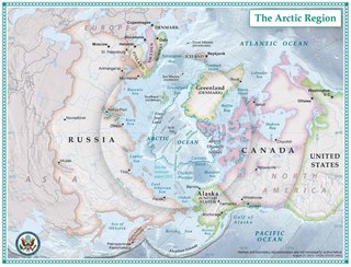
Frobisher Bay is an inlet of the Labrador Sea in the Qikiqtaaluk Region of Nunavut, Canada. It is located in the southeastern corner of Baffin Island. Its length is about 230 km (140 mi) and its width varies from about 40 km (25 mi) at its outlet into the Labrador Sea to roughly 20 km (12 mi) towards its inner end.

Georgian Bay is a large bay of Lake Huron, located entirely within Ontario, Canada. The main body of the bay lies east of the Bruce Peninsula and Manitoulin Island. To its northwest is the North Channel.

In geography, a sound is a large sea or ocean inlet, deeper than a bight and wider than a fjord; or a narrow sea or ocean channel between two bodies of land.

Howe Sound is a roughly triangular sound, or more precisely a network of fjords situated immediately northwest of Vancouver.

Innetalling Island is an uninhabited island in Qikiqtaaluk Region, Nunavut, Canada. Located in Hudson Bay's Omarolluk Sound, it is a member of the Belcher Islands group. It runs from Fairweather Sound at its northern end to Ridge Passage at its southern one. Fairweather Harbour is located on the north end of the island's east side.

Curry Island is an irregularly shaped, uninhabited island located in the Qikiqtaaluk Region of Nunavut, Canada. It is located at the mouth of White Bay, off Baffin Island. Eclipse Sound lies to its north.
Fletcher Island is a Baffin Island offshore island located in the Canadian Arctic Archipelago in the territory of Nunavut. The island lies in Frobisher Bay, north of Newell Sound. The Hall Peninsula is to the east. Islands in the immediate vicinity include: Field Island to the east; Bruce Island to the northeast; Pike and Pugh Islands to the west.
Lefferts Island is a Baffin Island offshore island located in the Canadian Arctic Archipelago in the territory of Nunavut. The island lies in Frobisher Bay between Beare Sound and Lupton Channel. Other islands also in the immediate vicinity of the tip of Hall Peninsula include the Harper Islands, Bear Island, Little Hall Island, and Hudson Island.
Opingivik Island is an uninhabited Baffin Island offshore island located in the Canadian Arctic Archipelago in Nunavut's Qikiqtaaluk Region. It lies in Cumberland Sound between Ikpit Bay to the north and Robert Peel Inlet approximately 18.6 km (11.6 mi) to the south.
Tangier Sound is a sound of the Chesapeake Bay bounded on the west by Tangier Island in Virginia, and Smith Island and South Marsh Island in Maryland, by Deal Island in Maryland on the north, and the mainland of the Eastern Shore of Maryland and Pocomoke Sound on the east. It stretches into Virginia as far south as Watts Island.

Kekerten Island is an uninhabited island in the Qikiqtaaluk Region of Nunavut, Canada. Southernmost of the Kikastan Islands, it is located in the Cumberland Sound, off Baffin Island's Cumberland Peninsula. Akulagok Island forms Kekerten Harbour with the island. Tuapait Island lies to the north. Beacon Island, Kekertukdjuak Island, Miliakdjuin Island, Tesseralik Island, and Ugpitimik Island are in the vicinity.
The Sanigut Islands are an uninhabited island group in the Qikiqtaaluk Region of Nunavut, Canada. They are located in Baffin Island's Cumberland Sound, just south of Avataktoo Bay. Aupaluktok Island is the southern one. Anarnittuq Island, Beacon Island, Imigen Island, Ivisa Island, Kekertelung Island, Saunik Island, Tesseralik Island, and Ugpitimik Island are in the vicinity.
Anarnittuq Island is an uninhabited island in the Qikiqtaaluk Region of Nunavut, Canada. It is located in Baffin Island's Cumberland Sound. It lies at the combined mouths of Clearwater and Shark Fiord, between Clear Passage Island and Kekertelung Island. The Sanigut Islands, Iglunga Island, and Nunatak Island are in the vicinity.

The Chatham Islands are a group of islands off the east coast of Oak Bay, British Columbia, Canada. All of the islands above the high tide mark are in Chatham Islands Indian Reserve No. 4, under the control of the Songhees First Nation. Chatham Islands foreshore - defined as the land between low tide and the beginning of land based vegetation - is provincial Crown Land.
Beacon Island is an uninhabited island located in the Qikiqtaaluk Region, Nunavut, Canada. It lies in the Nascopie Reefs, just east of Dorset Island, itself a Baffin Island offshore island in Hudson Strait. The closest community is Kimmirut, 20.9 km (13.0 mi) away.
Karlay Island is an uninhabited island in Qikiqtaaluk Region, Nunavut, Canada. Located in Hudson Bay, it is a member of the Belcher Islands group. It lies on the eastern side of Omarolluk Sound, between Nero Island to its north and Mata Island to its south. Other islands in the immediate vicinity include:
Mata Island is an uninhabited island in Qikiqtaaluk Region, Nunavut, Canada. Located in Hudson Bay, it is a member of the Belcher Islands group. It lies on the eastern side of Omarolluk Sound, just south of Karlay Island. Other islands in the immediate vicinity include:
Dove Island is an uninhabited island in Qikiqtaaluk Region, Nunavut, Canada. Located in Hudson Bay, it is a member of the Belcher Islands group. It lies in Omarolluk Sound between Tukarak Island and the southern half of Bradbury Island. Other islands in the immediate vicinity include:
La Duke Island is an uninhabited island in Qikiqtaaluk Region, Nunavut, Canada. Located in Hudson Bay, it is a member of the Belcher Islands group. It lies on the eastern side of Omarolluk Sound, across the mouth of Fairweather Sound. Other islands in the immediate vicinity include:
Walton Island is an uninhabited island in Qikiqtaaluk Region, Nunavut, Canada. Located in Hudson Bay, it is a member of the Belcher Islands group. It lies in Omarolluk Sound, west of Innetalling Island. The Camp Islands are to its south. Other islands in the immediate vicinity include: