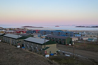
Frobisher Bay is an inlet of the Davis Strait in the Qikiqtaaluk Region of Nunavut, Canada. It is located in the southeastern corner of Baffin Island. Its length is about 230 km (140 mi) and its width varies from about 40 km (25 mi) at its outlet into the Davis Strait to roughly 20 km (12 mi) towards its inner end.

Pond Inlet is a small, predominantly Inuit community in the Qikiqtaaluk Region of Nunavut, Canada, located on northern Baffin Island. To the Inuit the name of the place "is and always has been Mittimatalik." The Scottish explorer Sir John Ross had named an arm of the sea that separates Bylot Island from Baffin Island as Pond's Bay, and the hamlet now shares that name. On 29 August 1921, the Hudson's Bay Company opened its trading post near the Inuit camp and named it Pond Inlet, marking the expansion of its trading empire into the High Arctic.
Inuvialuktun comprises several Inuit language varieties spoken in the northern Northwest Territories by Canadian Inuit who call themselves Inuvialuit. Some dialects and sub-dialects are also spoken in Nunavut.

Kitikmeot Region is an administrative region of Nunavut, Canada. It consists of the southern and eastern parts of Victoria Island with the adjacent part of the mainland as far as the Boothia Peninsula, together with King William Island and the southern portion of Prince of Wales Island. The regional centre is Cambridge Bay.

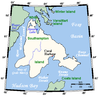
Southampton Island is a large island at the entrance to Hudson Bay at Foxe Basin. One of the larger members of the Arctic Archipelago, Southampton Island is part of the Kivalliq Region in Nunavut, Canada. The area of the island is stated as 41,214 km2 (15,913 sq mi) by Statistics Canada. It is the 34th largest island in the world and Canada's ninth largest island. The only settlement on Southampton Island is Coral Harbour, called Salliq in Inuktitut.

Ungava Bay is a bay in Nunavut, Canada separating Nunavik from Baffin Island. Although not geographically apparent, it is considered to be a marginal sea of the Arctic Ocean for climatic reasons. The bay is roughly oval-shaped, about 260 km (160 mi) at its widest point and about 320 km (200 mi) in length; it has an area of approximately 50,000 km2 (19,000 sq mi). It is generally fairly shallow, under 150 m (490 ft), though at its border with the Atlantic Ocean depths of almost 300 m (980 ft) are reached.
Skraeling Island is a Canadian island, located within the territory of Nunavut, which lies off of the east coast of Ellesmere Island at the mouth of Alexandra Fiord. Buchanan Bay lies to its north-east.

Flaherty Island is the largest island of the Belcher Islands group in Hudson Bay in Qikiqtaaluk Region, Nunavut, Canada.

Nunavut is the largest and northernmost territory of Canada. It was separated officially from the Northwest Territories on April 1, 1999, via the Nunavut Act and the Nunavut Land Claims Agreement Act, which provided this territory to the Inuit for self-government. The boundaries had been drawn in 1993. The creation of Nunavut resulted in the first major change to Canada's political map in half a century since the province of Newfoundland was admitted in 1949.
The Ottawa Islands are a group of currently uninhabited islands situated in the eastern edge of Canada's Hudson Bay. The group comprises 24 small islands, located at approximately 60N 80W. The main islands include Booth Island, Bronson Island, Eddy Island, Gilmour Island, J. Gordon Island, Pattee Island, and Perley Island. The highest point is on Gilmour Island, which rises to over 1,800 ft (550 m). Located a short distance off the northwest coast of Quebec's Ungava Peninsula, they, like the other coastal islands in Hudson Bay, were historically part of the Northwest Territories, and became Crown Land upon the creation of Nunavut in 1999. Nunavik Inuit have occupied these islands since time immemorial and gained constitutionally-protected harvest and access rights under the Nunavik Inuit Land Claim Agreement signed in 2007.
The uninhabited Point Islands are located in Hudson Strait's Diana Bay. Though they are near the Inuit hamlet of Quaqtaq, Quebec, they are part of the Qikiqtaaluk Region, in the Nunavut of Nunavut.
The uninhabited Arvalik Islands are part of the Qikiqtaaluk Region, in the Canadian territory of Nunavut. They are located in southeastern Ungava Bay, southwest of the Inuit hamlet of Kangiqsualujjuaq, Quebec and north of Imirqutailaisitik Island.
Denmark Bay is an Arctic waterway in Kitikmeot Region, Nunavut, Canada. It is located in western M'Clintock Channel, off the eastern coast of Victoria Island. It is separated from Homan Bay by a peninsula with a narrow isthmus.
Sutton Island is located in northern Canada's territory of Nunavut. It is situated in the Dolphin and Union Strait immediately next to Liston Island. Rymer Point and Simpson Bay, on Victoria Island's Wollaston Peninsula are to the northeast. Bernard Harbour, on the mainland, is to the southwest, as is Chantrey Island.
Dexterity Island is an uninhabited island in the Qikiqtaaluk Region of Nunavut, Canada. It is located in Baffin Bay off the northeastern coast of Baffin Island. Adams Island is 19.3 km (12.0 mi) to the south, while Bergesen Island is 17.2 km (10.7 mi) to the west, across Isbjorn Strait.
The Salikuit Islands are an uninhabited island group in the Qikiqtaaluk Region of Nunavut, Canada. The 103 island archipelago is located in eastern Hudson Bay between the Belcher Islands and the western coast of Quebec. The closest communities are the Inuit hamlets of Umiujaq, Quebec, 60 km to the east on the coast of Hudson Bay, and Sanikiluaq, 75 km (47 mi) to the west on Flaherty Island.
The Gyrfalcon Islands are an uninhabited island group in the Qikiqtaaluk Region of Nunavut, Canada. The over 200 small islands form an archipelago in western Ungava Bay north of Quebec's Ungava Peninsula and 19.7 km (12.2 mi) northeast of Leaf Bay. Tiercel Island and Qikirtajuaq Island lie to the southwest. The closest community is the Inuit village of Kuujjuaq, 120 km (75 mi) to the southeast.

Dundas Harbour is an abandoned settlement in the Qikiqtaaluk Region, Nunavut, Canada. It is located on Devon Island at the eastern shore of the waterway also named Dundas Harbour. Baffin Bay's Croker Bay is immediately to the west.
Dorchester Bay is an arm of the Foxe Basin in the Qikiqtaaluk Region of Nunavut, Canada. It is located on the northern coast of Foxe Peninsula, in western Baffin Island. Its western entrance point is Cape Willoughby. The closest community is Kinngait, situated 134 km (83 mi) to the south, while Nuwata, a former settlement, is situated 41 km (25 mi) to the west.

Kodlunarn Island, known as Qallunaaq in Inuktitut and originally named Countess of Warwick Island, is a small island located in Frobisher Bay in the Canadian territory of Nunavut. During the 1570s, explorer Martin Frobisher led expeditions to the island to mine what he believed was gold ore. The ore turned out to be worthless, and the island was ignored by explorers until Charles Francis Hall, inspired by oral history accounts from the Inuit of Frobisher Bay, visited the site in 1861 to investigate the remains of Frobisher's expeditions. Notable features of the island include two large mining trenches and the remains of a stone house built by Frobisher in 1578. Kodlunarn Island was designated a National Historic Site of Canada in 1964.


