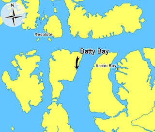
Batty Bay is a narrow bay in the Qikiqtaaluk Region, Nunavut, Canada. It is an arm of Prince Regent Inlet on the eastern side of Somerset Island.

Mount Maxwell Provincial Park is a provincial park in the Gulf Islands of British Columbia, Canada. It is located on Burgoyne Bay and the Sansum Narrows on the western shores of Saltspring Island.
Wager Bay or Ukkusiksalik Bay is long narrow inlet in the Kivalliq Region of Nunavut, Canada, which opens east into Roes Welcome Sound at the northwest end of Hudson Bay. Ukkusiksalik National Park surrounds it.

Highway 9 is a paved, undivided provincial highway in the Canadian province of Saskatchewan. It runs from North Dakota Highway 8 at the US border near Port of Northgate until it transitions into Provincial Road 283 at the Manitoba provincial boundary.
The Saskota Flyway is known as the International Road to Adventure, because it takes you from Hudson Bay, Saskatchewan, all the way south to Bismarck, North Dakota.
Tasiujaq formerly Murray Maxwell Bay is an uninhabited waterway in the Qikiqtaaluk Region, Nunavut, Canada. It is located in the Foxe Basin, north of Siuraarjuk on Baffin Island. The island of Kapuiviit lies at the opening of the bay.
Powell Inlet is a body of water in the Qikiqtaaluk Region of Nunavut, Canada. It lies off the southern coast of Devon Island in the eastern high Arctic. Like Stratton Inlet, Burnett Inlet, Hobhouse Inlet, and Cuming Inlet, Powell Inlet is situated between Maxwell Bay and Croker Bay, north of Lancaster Sound and Barrow Strait.
Cuming Inlet is a body of water in the Qikiqtaaluk Region of Nunavut, Canada. It lies off the southern coast of Devon Island in the eastern high Arctic. Like Stratton Inlet, Burnett Inlet, Hobhouse Inlet, and Powell Inlet, Cuming Inlet is situated between Maxwell Bay and Croker Bay, north of Lancaster Sound and Barrow Strait.
Croker Bay is an Arctic waterway in the Qikiqtaaluk Region, Nunavut, Canada. It lies off the southern coast of Devon Island in the eastern high Arctic. Like Maxwell Bay to the west, it is an arm of Lancaster Sound and Barrow Strait.
Macormick Bay is an Arctic waterway in the Qikiqtaaluk Region, Nunavut, Canada. It lies off the southwestern coast of Devon Island in the eastern high Arctic. Like Baring Bay to the north, it is an arm of Wellington Channel.
Baring Bay is an Arctic waterway in the Qikiqtaaluk Region, Nunavut, Canada. It lies off the southwestern coast of Devon Island in the eastern high Arctic. Like Macormick Bay to the south, it is an arm of Wellington Channel.
Irene Bay is an Arctic waterway in the Qikiqtaaluk Region. Nunavut, Canada. It is located in Eureka Sound by western Ellesmere Island.
Allman Bay is an arm of Nares Strait, in the Qikiqtaaluk Region of Nunavut, Canada. It is located in eastern Ellesmere Island, southwest of the southern edge of the Darling Peninsula. Dobbin Bay is 28 km (17 mi) to the northeast. Cape Prescott is the headland to the west of the entrance.
Peary Bay is an Arctic waterway in Qikiqtaaluk Region, Nunavut, Canada. It is located in Nares Strait by eastern Ellesmere Island between the Cook Peninsula and the Bache Peninsula.
The Gretha Islands are an uninhabited island group located in the Qikiqtaaluk Region of Nunavut, Canada. They are situated in Eureka Sound at the confluence of Bay Fjord, north of Ellesmere Island's Raanes Peninsula, and east of Stor Island. They are members of the Sverdrup Islands group, Queen Elizabeth Islands, and the Arctic Archipelago.

Killiniq is a former Inuit settlement, weather station, trading post, missionary post, fishing station, and Royal Canadian Mounted Police post on Killiniq Island. Previously within Labrador, and then the Northwest Territories, it is now situated within the borders of Nunavut. The community closed in 1978.
Herschel Bay is an Arctic waterway in the Qikiqtaaluk Region, Nunavut, Canada. It is located in Nares Strait, west of Smith Sound. Ellesmere Island is to the east, while Cape Sabine on Pim Island is to the northeast.
Campbell Bay is an Arctic waterway in Kitikmeot Region, Nunavut, Canada. It is located on the south side of the Queen Maud Gulf, east of White Bear Point on Nunavut's mainland.
Gibson Bay is an arm of the Foxe Basin in the Qikiqtaaluk Region of Nunavut, Canada. It is located on the northern coast of Foxe Peninsula, in western Baffin Island. The closest community is Kinngait, situated 123 km (76 mi) to the south, while Nuwata, a former settlement, is situated 77 km (48 mi) to the west. It is fed by the Kommanik River whose headwaters are at Kavivan Lake, 5 mi (8.0 km) to the southeast. Within the bay, there is a small island chain.
Harkin Bay is an arm of the Foxe Basin in the Qikiqtaaluk Region of Nunavut, Canada. It is located on the northeastern Foxe Peninsula, in western Baffin Island. The closest community, Kinngait, is situated 106 km (66 mi) to the south, while Nuwata, a former settlement, is situated 42 km (26 mi) to the west.
The Pork Peninsula is a cape located in Kivalliq Region, Nunavut, Canada. It is located on Hudson Bay, 30.1 km (18.7 mi) from the Inuit hamlet of Whale Cove, and 43.5 km (27.0 mi) from Rankin Inlet. The peninsula separates Corbett Inlet and Pistol Bay. Igloo Point is the eastern extremity of the peninsula.
