
Ellesmere Island is Canada's northernmost and third largest island, and the tenth largest in the world. It comprises an area of 196,236 km2 (75,767 sq mi), slightly smaller than Great Britain, and the total length of the island is 830 km (520 mi).

Victoria Island is a large island in the Arctic Archipelago that straddles the boundary between Nunavut and the Northwest Territories of Canada. It is the eighth-largest island in the world, and at 217,291 km2 (83,897 sq mi)1 in area, it is Canada's second-largest island. It is nearly double the size of Newfoundland (111,390 km2 [43,010 sq mi]), and is slightly larger than the island of Great Britain (209,331 km2 [80,823 sq mi]) but smaller than Honshu (225,800 km2 [87,200 sq mi]). The western third of the island lies in the Inuvik Region of the Northwest Territories; the remainder is part of Nunavut's Kitikmeot Region. The population of 2,168 is divided between two settlements, the larger of which is Cambridge Bay (Nunavut) and the other Ulukhaktok.

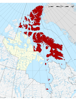
The Arctic Archipelago, also known as the Canadian Arctic Archipelago, is an archipelago lying to the north of the Canadian continental mainland, excluding Greenland and Iceland.

Ellesmere is a town in the civil parish of Ellesmere Urban, in Shropshire, England; it is located near to the Welsh border, the towns of Oswestry and Whitchurch, and the Welsh city of Wrexham. It is notable for its proximity to a number of prominent meres.
The Qikiqtaaluk Region, Qikiqtani Region or the Baffin Region is the easternmost, northernmost, and southernmost administrative region of Nunavut, Canada. Qikiqtaaluk is the traditional Inuktitut name for Baffin Island. Although the Qikiqtaaluk Region is the most commonly used name in official contexts, several notable public organizations, including Statistics Canada prior to the 2021 Canadian census, use the older term Baffin Region.

The Queen Elizabeth Islands are the northernmost cluster of islands in Canada's Arctic Archipelago, split between Nunavut and the Northwest Territories in Northern Canada. The Queen Elizabeth Islands contain approximately 14% of the global glacier and ice cap area. The southern islands are called the Parry Islands or Parry Archipelago.
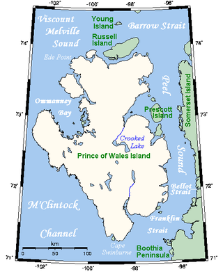
Prince of Wales Island is an Arctic island in Nunavut, Canada. One of the larger members of the Arctic Archipelago, it lies between Victoria Island and Somerset Island and is south of the Queen Elizabeth Islands.

Cornwall Island is a small, uninhabited island in the high Arctic region of the Canadian territory of Nunavut. It is near the geometric centre of the Queen Elizabeth Islands. To the north, it is separated from Amund Ringnes Island by Hendriksen Strait. To the south, it is separated from Devon Island by Belcher Channel. It is the largest of six islands in Norwegian Bay, west of Ellesmere Island.

Prescott Island is one of the uninhabited Canadian Arctic islands in the territory of Nunavut. The island is situated in Peel Sound, between the Prince of Wales Island and Somerset Island.
Prince of Wales is the title traditionally given to the heir apparent to the reigning monarch of the United Kingdom.

The Arctic Cordillera is a terrestrial ecozone in northern Canada characterized by a vast, deeply dissected chain of mountain ranges extending along the northeastern flank of the Canadian Arctic Archipelago from Ellesmere Island to the northeasternmost part of the Labrador Peninsula in northern Labrador and northern Quebec, Canada. It spans most of the eastern coast of Nunavut with high glaciated peaks rising through ice fields and some of Canada's largest ice caps, including the Penny Ice Cap on Baffin Island. It is bounded to the east by Baffin Bay, Davis Strait and the Labrador Sea while its northern portion is bounded by the Arctic Ocean.
The Prince of Wales Mountains are a mountain range running along the central-east coast of Ellesmere Island, Nunavut, Canada. The range is one of the most northern ranges in the world and of the Arctic Cordillera, which is a vast deeply dissected mountain range from Ellesmere Island to the northernmost tip of Labrador. The Prince of Wales Icefield lies mostly in the range.

The Agassiz Ice Cap formerly Agassiz Glacier is an ice cap on the central eastern side of Ellesmere Island, Nunavut, Canada. The Agassiz ice cap is about 21,000 km2 (8,100 sq mi) in area. It is located between the North Ellesmere ice field to the north and the Prince of Wales Icefield to the south.
Sven Hedin Glacier is a glacier north of Princess Marie Bay on central Ellesmere Island, Nunavut, Canada. The glacier has the name of Sven Hedin. The Oxford University Ellesmere Land expedition visited the glacier in the year 1935. The Glacier appeared to be advancing in 1935.

Pim Island is an uninhabited island located off the eastern coast of Ellesmere Island, part of the Qikiqtaaluk Region of the Canadian territory of Nunavut. Located within the Arctic Archipelago, it is a part of the Queen Elizabeth Islands.
Norman Lockyer Island is located off the eastern coast of Ellesmere Island, and a part of the Qikiqtaaluk Region of the Canadian territory of Nunavut. Situated in Princess Marie Bay just in front of Franklin Pierce Bay, 9 km (5.6 mi) WSW of Cape Prescott, north of Bache Peninsula, Norman Lockyer Island is within the Arctic Archipelago, a member of the Queen Elizabeth Islands.
Okse Bay is an Arctic waterway in Qikiqtaaluk Region, Nunavut, Canada. It is located in Norwegian Bay by southwestern Ellesmere Island, east of Buckingham Island.
Irene Bay is an Arctic waterway in Qikiqtaaluk Region. Nunavut, Canada. It is located in Eureka Sound by western Ellesmere Island.
