
A barn is an agricultural building usually on farms and used for various purposes. In North America, a barn refers to structures that house livestock, including cattle and horses, as well as equipment and fodder, and often grain. As a result, the term barn is often qualified e.g. tobacco barn, dairy barn, cow house, sheep barn, potato barn. In the British Isles, the term barn is restricted mainly to storage structures for unthreshed cereals and fodder, the terms byre or shippon being applied to cow shelters, whereas horses are kept in buildings known as stables. In mainland Europe, however, barns were often part of integrated structures known as byre-dwellings. In addition, barns may be used for equipment storage, as a covered workplace, and for activities such as threshing.
Mike Beres is a male badminton player from Canada, who won the bronze medal in the men's doubles competition at the 1999 Pan American Games. He was born in Brantford, Ontario.

Bantry Bay is a bay located in County Cork, Ireland. The bay runs approximately 35 km (22 mi) from northeast to southwest into the Atlantic Ocean. It is approximately 3-to-4 km wide at the head and 10 km (6.2 mi) wide at the entrance.

Bere Regis is a village and civil parish in Dorset, England, situated 6 miles (9.7 km) north-west of Wareham. In the 2011 census the civil parish had a population of 1,745.

Beres Hammond OJ is a Jamaican reggae singer known in particular for his lovers rock music. While his career began in the 1970s, he reached his greatest success in the 1990s.

Bere Ferrers, sometimes called Beerferris, is a village and civil parish on the Bere peninsula in West Devon in the English county of Devon. It is located to the north of Plymouth, on the west bank of the River Tavy. It has a railway station on the Tamar Valley Line.

Bere Island or Bear Island is an island in Bantry Bay off the Beara Peninsula in County Cork, Ireland. It spans roughly 10 km x 3 km, with an area of 17.68 km2 and, as of the 2022 census, had a population of 218 people.

Sointula is an isolated village on Malcolm Island in British Columbia, Canada. Lying between Vancouver Island and the British Columbia mainland, northeast of Port McNeill and not far from Alert Bay, the island is part of the historic and present territory of the ‘Namgis First Nation. At the 2011 census, the village had a population of 576, down 3.0% from the 2006 census.

Alexandra Béres is fitness world champion, curling pro and a magazine cover model from Hungary. In Hungary, she is well known as a "fitness legend" according to The Curling News.

Castell y Bere is a Welsh castle near Llanfihangel-y-pennant in Gwynedd, Wales. Constructed by Llywelyn the Great in the 1220s, the stone castle was intended to maintain his authority over the local people and to defend the south-west part of the princedom of Gwynedd. In 1282, war with Edward I of England resulted in the death of Llywelyn's grandson, Llywelyn ap Gruffudd, and Castell y Bere fell to English forces. Edward I expanded the castle further and established a small town beside it. In 1294 the Welsh leader Madog ap Llywelyn mounted a major revolt and the castle was besieged and apparently burnt. Edward did not repair it and it became ruined. Today it is in the hands of Cadw and operated as a tourist attraction.
The Cincinnati Reds' 1998 season was a season in American baseball. It consisted of the Cincinnati Reds attempting to win the National League Central.
Triton Bay is an Arctic waterway in Qikiqtaaluk Region, Nunavut, Canada. It is located in Norwegian Bay off Devon Island's Grinnell Peninsula. Bere Bay is to the northwest.

Canada participated at the 2003 Pan American Games, held in Santo Domingo, Dominican Republic, from 1 to 17 August 2003.
Bara Bará Bere Berê is a popular Brazilian song in Portuguese. The refrain is a Bahian protect song created by Dorgival Dantas, with folk dance, rhythmic samba and merengue influences. The song has been subject to various interpretations by a great number of Brazilian artists, and various lyrics and additional music added to the original Dorgival Dantas version.
Valérie "Val" Loker is a Canadian badminton player. She won a silver medal, along with her partner Mike Beres in the mixed doubles at the 2007 Pan American Games in Rio de Janeiro, Brazil, against the winning U.S. pair Howard Bach and Eva Lee, with a score of 18–21 and 17–21. Loker is also a member of Club Excellence Yonex Laval in Montreal, Quebec, and is coached and trained by Jean-Paul Girard.
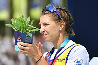
Mădălina Bereș is a Romanian rower. She competed in the coxless pair and the women's eight event at the 2016 Summer Olympics and won a bronze medal in the women eight event. She is also World and European champion.
Bere Point is a regional park in British Columbia, Canada, located on Malcolm Island in the Queen Charlotte Strait region of the Central Coast.

Amalia Bereș is a Romanian rower. She competed in the women's eight event at the 2020 Summer Olympics.

Timișoreana Brewery is the first brewery established on the current territory of Romania, in the Fabric district of Timișoara, in 1718. The brewery is owned today by Ursus Breweries and has a technical capacity of 3.1 million hectoliters per year. It currently produces around 2.6–2.7 million hectoliters of beer annually, which means over 16% of the annual local production estimated at over 16 million hectoliters of beer. Eleven brands are produced here, including Timișoreana, Ursus, Grolsch or Stejar; moreover, Timișoreana is the best-selling beer brand in Romania.
