
Baffin Island, in the Canadian territory of Nunavut, is the largest island in Canada, the second largest island in the Americas, and the fifth-largest island in the world. Its area is 507,451 km2 (195,928 sq mi) with a population density of 0.03/km2; the population was 13,039 according to the 2021 Canadian census; and it is located at 68°N70°W. It also contains the city of Iqaluit, which is the capital of Nunavut.

Victoria Island is a large island in the Arctic Archipelago that straddles the boundary between Nunavut and the Northwest Territories of Canada. It is the eighth-largest island in the world, and at 217,291 km2 (83,897 sq mi)1 in area, it is Canada's second-largest island. It is nearly double the size of Newfoundland (111,390 km2 [43,010 sq mi]), and is slightly larger than the island of Great Britain (209,331 km2 [80,823 sq mi]) but smaller than Honshu (225,800 km2 [87,200 sq mi]). The western third of the island lies in the Inuvik Region of the Northwest Territories; the remainder is part of Nunavut's Kitikmeot Region. The population of 2,168 is divided between two settlements, the larger of which is Cambridge Bay (Nunavut) and the other Ulukhaktok.
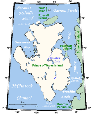
Prince of Wales Island is an Arctic island in Nunavut, Canada. One of the larger members of the Arctic Archipelago, it lies between Victoria Island and Somerset Island and is south of the Queen Elizabeth Islands.

Melville Peninsula is a large peninsula in the Canadian Arctic north of Hudson Bay. To the east is Foxe Basin and to the west the Gulf of Boothia. To the north the Fury and Hecla Strait separates it from Baffin Island. To the south Repulse Bay and Frozen Strait separate it from Southampton Island at the north end of Hudson Bay. On the southwest it is connected to the mainland by the Rae Isthmus, named after the Arctic explorer John Rae.

Loks Land is an uninhabited island in the Arctic Archipelago in Nunavut, Canada. It is located off the eastern tip of Baffin Island's Blunt Peninsula, close to the mouth of Frobisher Bay. It has an area of 419 km2 (162 sq mi) and a coastline of 206 km. The local Inuktitut name for the island is Takuligjuaq.
Norman Lockyer Island is located off the eastern coast of Ellesmere Island, and a part of the Qikiqtaaluk Region of the Canadian territory of Nunavut. Situated in Princess Marie Bay just in front of Franklin Pierce Bay, 9 km (5.6 mi) WSW of Cape Prescott, north of Bache Peninsula, Norman Lockyer Island is within the Arctic Archipelago, a member of the Queen Elizabeth Islands.
Smith Island is a northern Canadian island in eastern Hudson Bay. It is a part of Qikiqtaaluk Region in the territory of Nunavut, though situated 2 km (1.2 mi) off the western coast of Quebec's Ungava Peninsula.
The Back Peninsula is a cape located on eastern Bell Peninsula, Southampton Island, in the Kivalliq Region, Nunavut, Canada. Its southern shore is part of the northern boundary of Hudson Bay. Foxe Basin is to the north. There are two large bays, Gorden Bay and Junction Bay. Bowhead whale frequent the area. The Bell Peninsula's irregular coastline is marked by Seashore Point and Expectation Point.
The Knud Peninsula is located on the eastern coast of Ellesmere Island, a part of the Qikiqtaaluk Region of the Canadian territory of Nunavut. It stretches eastward into Nares Strait. It is separated from the Bache Peninsula by Flagler Bay.
Sabine Island is an uninhabited island located in Nunavut's Qikiqtaaluk Region within the northern Canadian Arctic. It is in eastern Gulf of Boothia's Committee Bay, south of Wales Island and west of the mainland's Melville Peninsula.
Prince Alfred Bay is a waterway in Qikiqtaaluk Region, Nunavut, Canada. It lies off the western coast of Devon Island, forming a border of the Grinnell Peninsula, in the eastern high Arctic. Like Pioneer Bay to the south, it is an arm of Wellington Channel.
Irene Bay is an Arctic waterway in Qikiqtaaluk Region. Nunavut, Canada. It is located in Eureka Sound by western Ellesmere Island.
Scoresby Bay is an Arctic waterway in Qikiqtaaluk Region, Nunavut, Canada. It is located in Nares Strait by eastern Ellesmere Island's Darling Peninsula, west of Nunatami, Greenland.

Dobbin Bay is an Arctic waterway in the Qikiqtaaluk Region, Nunavut, Canada. It is located in the Kane Basin, Nares Strait by eastern Ellesmere Island, south of the Darling Peninsula.
Peary Bay is an Arctic waterway in Qikiqtaaluk Region, Nunavut, Canada. It is located in Nares Strait by eastern Ellesmere Island between the Cook Peninsula and the Bache Peninsula.
Bartlett Bay is an Arctic waterway in the Qikiqtaaluk Region, Nunavut, Canada. It is in Nares Strait off eastern Ellesmere Island, off the Bache Peninsula. Victoria Head marks the northern tip of its mouth.
Buchanan Bay is an Arctic waterway in Qikiqtaaluk Region, Nunavut, Canada. It is located in Nares Strait by eastern Ellesmere Island. The bay is bordered by Cape Camperdown on Bache Peninsula to the north, Cape Rutherford on Johan Peninsula to the south, and the Alexandra Fiord at its head.
Cape Hewett is a peninsula on eastern Baffin Island, Qikiqtaaluk Region, Nunavut, Canada. Located on Baffin Bay near Clyde Inlet, the closest settlement is Clyde River, 39.6 kilometres (24.6 mi) away.

The Remote Peninsula is a peninsula located on the eastern coast of Baffin Island. It is part of the Qikiqtaaluk Region of the Canadian territory of Nunavut. The Inuit settlement of Pond Inlet is 295 km (183 mi) to the northwest and Clyde River is 90 km (56 mi) to the southeast.
