
Cape Breton Island is a rugged and irregularly shaped island on the Atlantic coast of North America and part of the province of Nova Scotia, Canada.

The Bay of Fundy is a bay between the Canadian provinces of New Brunswick and Nova Scotia, with a small portion touching the U.S. state of Maine. It is an arm of the Gulf of Maine. Its tidal range is the highest in the world. The name is probably a corruption of the French word fendu, meaning 'split'.

Henry Parry Liddon (1829–1890), usually cited as H. P. Liddon, was an English Anglican theologian. From 1870 to 1882, he was Dean Ireland's Professor of the Exegesis of Holy Scripture at the University of Oxford.
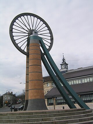
Radstock is a town and civil parish on the northern slope of the Mendip Hills in Somerset, England, about 9 miles (14 km) south-west of Bath and 8 miles (13 km) north-west of Frome. It is within the area of the unitary authority of Bath and North East Somerset. The Radstock built-up area had a population of 9,419 at the 2011 Census.

Devon Island is an island in Canada and the largest uninhabited island in the world. It is located in Baffin Bay, Qikiqtaaluk Region, Nunavut, Canada. It is one of the largest members of the Arctic Archipelago, the second-largest of the Queen Elizabeth Islands, Canada's sixth-largest island, and the 27th-largest island in the world. It has an area of 55,247 km2 (21,331 sq mi). The bedrock is Precambrian gneiss and Paleozoic siltstones and shales. The highest point is the Devon Ice Cap at 1,920 m (6,300 ft) which is part of the Arctic Cordillera. Devon Island contains several small mountain ranges, such as the Treuter Mountains, Haddington Range and the Cunningham Mountains. The notable similarity of its surface to that of Mars has attracted interest from scientists.
Glace Bay is a community in the eastern part of the Cape Breton Regional Municipality in Nova Scotia, Canada. It forms part of the general area referred to as Industrial Cape Breton.

Admiral William Waldegrave, 1st Baron Radstock, GCB was an officer in the Royal Navy and Governor of Newfoundland.
Cape Scott Provincial Park extends from Shushartie in the east, then westward around Cape Scott and south to San Josef Bay. This coastline comprises the northern tip of Vancouver Island, British Columbia. The 22,294-hectare (55,090-acre) provincial park is about 563 km (350 mi) northwest of Victoria.

Clandown is a village lying north of Radstock in Somerset, England, just off the Fosseway. It is 1 mile (1.6 km) north of Radstock. The nearby Bowlditch Quarry is a 0.25 hectare geological Site of Special Scientific Interest.
The Bristol and North Somerset Railway was a railway line in the West of England that connected Bristol with Radstock, through Pensford and further into northern Somerset, to allow access to the Somerset Coalfield. The line ran almost due south from Bristol and was 16 miles (26 km) long.
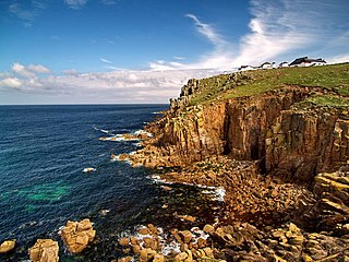
A headland, also known as a head, is a coastal landform, a point of land usually high and often with a sheer drop, that extends into a body of water. It is a type of promontory. A headland of considerable size often is called a cape. Headlands are characterised by high, breaking waves, rocky shores, intense erosion, and steep sea cliff.
Captain Henry Parkyns Hoppner was an officer of the Royal Navy, Arctic explorer, draughtsman and artist. His career included two ill-fated voyages culminating in the loss of HMS Alceste in 1816 and HMS Fury in 1825.
Cape Hoppner is a land point on Melville Island, Northwest Territories, Canada. It juts into the southern section of Liddon Gulf across from Barry Bay.
Saglirjuaq formerly Liddon Island is one of several irregularly shaped islands located in the Fury and Hecla Strait of Nunavut's Qikiqtaaluk Region within the northern Canadian Arctic. It is north of the mainland's Melville Peninsula, south of Baffin Island's Sikosak Bay, west of Simialuk, and east of Saglaarjuk.
Saglaarjuk formerly Amherst Island is one of several uninhabited, irregularly shaped islands located on the south side of the Fury and Hecla Strait of Nunavut's Qikiqtaaluk Region within the northern Canadian Arctic. It is west of Liddon Island, north of Grinnell Lake on the mainland's Melville Peninsula, and south of Baffin Island.
Cape Liddon is an uninhabited headland on Devon Island in the Qikiqtaaluk Region of Nunavut, Canada. It is located on the southwestern coast of the island at Radstock Bay.

Anxious Bay is a bay in the Australian state of South Australia located on the west coast of Eyre Peninsula about 275 kilometres west north-west of Adelaide. It was named by Matthew Flinders on 21 February 1802. It is one of four ‘historic bays’ located on the South Australian coast.
Cape Radstock is a headland located on the west coast of Eyre Peninsula in South Australia about 45 kilometres south south-east of the town of Streaky Bay and about 9.3 kilometres (5 nmi) south east of Point Labatt. The cape is both the north western extremity of Anxious Bay and the southern extremity of the Calca Peninsula. The cape is described as being “steep and bold” and where the cliffs reach a height of 135 metres, being the high point of a line of cliffs starting at Point Labatt in the west and from within Anxious Bay in the east. It was named by Matthew Flinders on 9 February 1802 after William Waldegrave, 1st Baron Radstock. Since 2012, the waters adjoining its shoreline are within a habitat protection zone in the West Coast Bays Marine Park.

Calca Peninsula is a peninsula in the Australian state of South Australia located on the west coast of Eyre Peninsula in the locality of Sceale Bay about 27 kilometres to about 46 kilometres south-east of the town of Streaky Bay.

