
Robert Edwin Peary Sr. was an American explorer and officer in the United States Navy who made several expeditions to the Arctic in the late 19th and early 20th centuries. He was long credited as being the discoverer of the geographic North Pole in April 1909, having led the first expedition to have claimed this achievement, although it is now considered unlikely that he actually reached the Pole.

Victoria Island is a large island in the Arctic Archipelago that straddles the boundary between Nunavut and the Northwest Territories of Canada. It is the eighth-largest island in the world, and at 217,291 km2 (83,897 sq mi)1 in area, it is Canada's second-largest island. It is nearly double the size of Newfoundland (111,390 km2 [43,010 sq mi]), and is slightly larger than the island of Great Britain (209,331 km2 [80,823 sq mi]) but smaller than Honshu (225,800 km2 [87,200 sq mi]). The western third of the island lies in the Inuvik Region of the Northwest Territories; the remainder is part of Nunavut's Kitikmeot Region. The population of 2,168 is divided between two settlements, the larger of which is Cambridge Bay (Nunavut) and the other Ulukhaktok.

Frederick Albert Cook was an American explorer, physician and ethnographer, who is most known for allegedly being the first to reach the North Pole on April 21, 1908. A competing claim was made a year later by Robert Peary, though both men's accounts have since been fiercely disputed; in December 1909, after reviewing Cook's limited records, a commission of the University of Copenhagen ruled his claim unproven. Nonetheless, in 1911, Cook published a memoir of the expedition in which he maintained the veracity of his assertions. In addition, he also claimed to have been the first person to reach the summit of Denali, the highest mountain in North America, a claim which has since been similarly discredited. Though he may not have achieved either Denali or the North Pole, his was the first and only expedition where a United States national discovered an Arctic island, Meighen Island.
Cape York is a cape on the northwestern coast of Greenland, in northern Baffin Bay.

Effie M. Morrissey is a schooner skippered by Robert Bartlett that made many scientific expeditions to the Arctic, sponsored by American museums, the Explorers Club and the National Geographic Society. She also helped survey the Arctic for the United States Government during World War II. She is currently designated by the United States Department of the Interior as a National Historic Landmark as part of the New Bedford Whaling National Historical Park. She is the State Ship of Massachusetts.

The Ward Hunt Ice Shelf is the largest ice shelf in the Arctic, located near Ward Hunt Island, on the north coast of Ellesmere Island, Nunavut, Canada. During the 20th century the Ellesmere Ice Shelf broke up into six separate shelves, the largest being Ward Hunt. Ward Hunt Ice Shelf is currently about 400 km2 (150 sq mi) in size, and has been in place for approximately 4,000 years as part of a continuous ice shelf that encompassed the northern coast of Ellesmere Island until the beginning of the twentieth century. In 2005 one of the other shelves, the 65 km2 (25 sq mi) Ayles Ice Shelf, calved completely.
Cape Thomas Hubbard is a headland located in the northern Canadian territory of Nunavut. Projecting into the Arctic Ocean, it is situated on the northern tip of Axel Heiberg Island, 320 mi (510 km) from Etah, Greenland.
Princess Marie Bay is an Arctic waterway in the Qikiqtaaluk Region, Nunavut, Canada. It is located in Nares Strait by eastern Ellesmere Island, and marks the southwestern edge of Cook Peninsula. It is also south of the Sven Hedin Glacier.
Peary Bay is an Arctic waterway in the Qikiqtaaluk Region, Nunavut, Canada. It is located in Nares Strait by eastern Ellesmere Island between the Cook Peninsula and the Bache Peninsula.

Fort Conger is a former settlement, military fortification, and scientific research post in the Qikiqtaaluk Region, Nunavut, Canada. It was established in 1881 as an Arctic exploration camp, notable as the site of the first major northern polar region scientific expedition, the Lady Franklin Bay Expedition, led by Adolphus Greely as part of the United States government's contribution to the First International Polar Year. It was later occupied by Robert Peary during some of his Arctic expeditions.
The Peary Arctic Club was an American-based club with the goal of promoting the Arctic expeditions of Robert Peary (1856–1920).
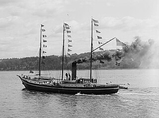
SS Roosevelt was an American steamship of the early 20th century. She was designed and constructed specifically for Robert Peary′s polar exploration expeditions, and she supported the 1908 expedition in which he claimed to have discovered the North Pole.

The Roosevelt Range or Roosevelt Mountains is a mountain range in Northern Greenland. Administratively this range is part of the Northeast Greenland National Park. Its highest peak is the highest point in Peary Land.

Cape Cannon is a headland in the Lincoln Sea, Arctic Ocean, North Greenland. Administratively it is part of the Northeast Greenland National Park.

The Peary Channel was a hypothetical sound or marine channel running from east to west separating Peary Land in northernmost Greenland from the mainland further south.
Cape James Hill is a headland in the Wandel Sea, Arctic Ocean, northeast Greenland.
Cape Clarence Wyckoff, also known as Cape Wyckoff, is a broad headland in the Wandel Sea, Arctic Ocean, northernmost Greenland. Administratively it is part of the Northeast Greenland National Park.

Herluf Trolle Land is an area in Peary Land, North Greenland. Administratively it is part of the Northeast Greenland National Park.
