
Ellesmere Island is Canada's northernmost and third largest island, and the tenth largest in the world. It comprises an area of 196,236 km2 (75,767 sq mi), slightly smaller than Great Britain, and the total length of the island is 830 km (520 mi).

Sir John Franklin was a British Royal Navy officer, explorer and colonial administrator. After serving in the Napoleonic Wars and the War of 1812, he led two expeditions into the Canadian Arctic and through the islands of the Arctic Archipelago, during the Coppermine expedition of 1819 and the Mackenzie River expedition of 1825, and served as Lieutenant-Governor of Van Diemen's Land from 1837 to 1843. During his third and final expedition, an attempt to traverse the Northwest Passage in 1845, Franklin's ships became icebound off King William Island in what is now Nunavut, where he died in June 1847. The icebound ships were abandoned ten months later, and the entire crew died from causes such as starvation, hypothermia, and scurvy.

HMS Erebus was a Hecla-class bomb vessel constructed by the Royal Navy in Pembroke dockyard, Wales, in 1826. The vessel was the second in the Royal Navy named after Erebus, the personification of darkness in Greek mythology.

HMS Terror was a specialised warship and a newly developed bomb vessel constructed for the Royal Navy in 1813. She participated in several battles of the War of 1812, including the Battle of Baltimore with the bombardment of Fort McHenry. She was converted into a polar exploration ship two decades later, and participated in George Back's Arctic expedition of 1836–1837, the successful Ross expedition to the Antarctic of 1839 to 1843, and Sir John Franklin's ill-fated attempt to force the Northwest Passage in 1845, during which she was lost with all hands along with HMS Erebus.

Adolphus Washington Greely was a United States Army officer and polar explorer. He attained the rank of major general and was a recipient of the Medal of Honor.

Kane Basin is an Arctic waterway lying between Greenland and Ellesmere Island, Canada's northernmost. It links Smith Sound to Kennedy Channel and forms part of Nares Strait. It is approximately 180 km (110 mi) in length and 130 km (81 mi) at its widest.

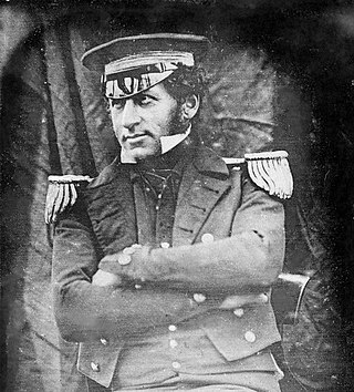
Francis Rawdon Moira Crozier was an Irish officer of the Royal Navy and polar explorer who participated in six expeditions to the Arctic and Antarctic. In 1843, he became a Fellow of the Royal Society for his scientific work during his expeditions. Later, he was second-in-command to Sir John Franklin and captain of HMS Terror during the Franklin expedition to discover the Northwest Passage, which ended with the loss of all 129 crewmen in mysterious circumstances.

Sir Edward Augustus Inglefield was a Royal Navy officer who led one of the searches for the missing Arctic explorer John Franklin during the 1850s. In doing so, his expedition charted previously unexplored areas along the northern Canadian coastline, including Baffin Bay, Smith Sound and Lancaster Sound.
Cape Sabine is a land point on Pim Island, off the eastern shores of the Johan Peninsula, Ellesmere Island, in the Smith Sound, Qikiqtaaluk Region, Nunavut, Canada.

The MacGregor Arctic Expedition was a privately funded expedition which set out to reoccupy Fort Conger, Ellesmere Island, Canada, a site within flying distance of the North Pole. The expedition, which took place from July 1, 1937, to October 3, 1938, had four main objectives: To collect weather data; to make a magnetic survey; to photograph the aurora borealis and study its effects upon radio transmission; and to explore the area northwest of Ellesmere Island, in order to clear up the questions about Crocker Land, which Robert Peary placed on the map more than 30 years earlier.

Franklin's lost expedition was a failed British voyage of Arctic exploration led by Captain Sir John Franklin that departed England in 1845 aboard two ships, HMS Erebus and HMS Terror, and was assigned to traverse the last unnavigated sections of the Northwest Passage in the Canadian Arctic and to record magnetic data to help determine whether a better understanding could aid navigation. The expedition met with disaster after both ships and their crews, a total of 129 officers and men, became icebound in Victoria Strait near King William Island in what is today the Canadian territory of Nunavut. After being icebound for more than a year, Erebus and Terror were abandoned in April 1848, by which point two dozen men, including Franklin, had died. The survivors, now led by Franklin's second-in-command, Francis Crozier, and Erebus's captain, James Fitzjames, set out for the Canadian mainland and disappeared, presumably having perished.

Pim Island is an uninhabited island located off the eastern coast of Ellesmere Island, part of the Qikiqtaaluk Region of the Canadian territory of Nunavut. Located within the Arctic Archipelago, it is a part of the Queen Elizabeth Islands.
Cocked Hat Island, located off the eastern coast of Ellesmere Island, is a part of the Qikiqtaaluk Region of the Canadian territory of Nunavut. The island is located within the Arctic Archipelago, and is a part of the Queen Elizabeth Islands.

The Lady Franklin Bay Expedition of 1881–1884 to Lady Franklin Bay on Ellesmere Island in the Canadian Arctic was led by Lieutenant Adolphus Greely, and was promoted by the United States Army Signal Corps. Its purpose was to establish a meteorological-observation station as part of the First International Polar Year, and to collect astronomical and magnetic data. During the expedition, two members of the crew reached a new Farthest North record, but of the original twenty-five men, only seven survived to return.

Fort Conger is a former settlement, military fortification, and scientific research post in the Qikiqtaaluk Region, Nunavut, Canada. It was established in 1881 as an Arctic exploration camp, notable as the site of the first major northern polar region scientific expedition, the Lady Franklin Bay Expedition, led by Adolphus Greely as part of the United States government's contribution to the First International Polar Year. It was later occupied by Robert Peary during some of his Arctic expeditions.
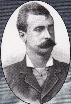
George Walter Rice was a Canadian photographer who was first to photograph the Arctic region on the ill-fated American led Lady Franklin Bay Expedition of 1881 to 1884. Rice died in the Arctic on 9 April 1884 while awaiting the arrival of a relief vessel.

Thomas Abernethy was a Scottish seafarer, gunner in the Royal Navy, and polar explorer. Because he was neither an officer nor a gentleman, he was little mentioned in the books written by the leaders of the expeditions he went on, but was praised in what was written. In 1857, he was awarded the Arctic Medal for his service as an able seaman on the 1824–25 voyage of HMS Hecla, the first of his five expeditions for which participants were eligible for the award. He was in parties that, for their time, reached the furthest north, the furthest south (twice), and the nearest to the South Magnetic Pole. In 1831, along with James Clark Ross's team of six, Abernethy was in the first party ever to reach the North Magnetic Pole.
Graham Gore was an English officer of the Royal Navy and polar explorer who participated in two expeditions to the Arctic and a survey of the coastline of Australia aboard HMS Beagle. In 1845 he served under Sir John Franklin as First Lieutenant on the Erebus during the Franklin expedition to discover the Northwest Passage, which ended with the loss of all 129 officers and crewmen in mysterious circumstances.

Lockwood Island is an island of the Lincoln Sea, Greenland. Administratively it belongs to the Northeast Greenland National Park.
