
Ellesmere Island is Canada's northernmost and third largest island, and the tenth largest in the world. It comprises an area of 196,236 km2 (75,767 sq mi), slightly smaller than Great Britain, and the total length of the island is 830 km (520 mi).

Baffin Island, in the Canadian territory of Nunavut, is the largest island in Canada, the second-largest island in the Americas, and the fifth-largest island in the world. Its area is 507,451 km2 (195,928 sq mi) with a population density of 0.03/km2; the population was 13,039 according to the 2021 Canadian census; and it is located at 68°N70°W. It also contains the city of Iqaluit, which is the capital of Nunavut.

Victoria Island is a large island in the Arctic Archipelago that straddles the boundary between Nunavut and the Northwest Territories of Canada. It is the eighth-largest island in the world, and at 217,291 km2 (83,897 sq mi)1 in area, it is Canada's second-largest island. It is nearly double the size of Newfoundland (111,390 km2 [43,010 sq mi]), and is slightly larger than the island of Great Britain (209,331 km2 [80,823 sq mi]) but smaller than Honshu (225,800 km2 [87,200 sq mi]). The western third of the island lies in the Inuvik Region of the Northwest Territories; the remainder is part of Nunavut's Kitikmeot Region. The population of 2,168 is divided between two settlements, the larger of which is Cambridge Bay (Nunavut) and the other Ulukhaktok.
Churchill is an Arctic port town in northern Manitoba, Canada, on the west shore of Hudson Bay, roughly 140 km (87 mi) from the Manitoba–Nunavut border. It is most famous for the many polar bears that move toward the shore from inland in the autumn, leading to the nickname "Polar Bear Capital of the World" and to the benefit of its burgeoning tourism industry.

Baffin Bay, located between Baffin Island and the west coast of Greenland, is defined by the International Hydrographic Organization as a marginal sea of the Arctic Ocean. It is sometimes considered a sea of the North Atlantic Ocean. It is connected to the Atlantic via Davis Strait and the Labrador Sea. The narrower Nares Strait connects Baffin Bay with the Arctic Ocean. The bay is not navigable most of the year because of the ice cover and high density of floating ice and icebergs in the open areas. However, a polynya of about 80,000 km2 (31,000 sq mi), known as the North Water, opens in summer on the north near Smith Sound. Most of the aquatic life of the bay is concentrated near that region.
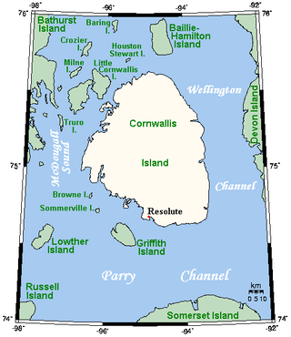
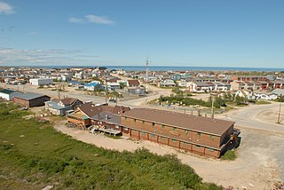
Cornwallis Island is one of the Queen Elizabeth Islands, part of the Arctic Archipelago, in the Qikiqtaaluk Region of Nunavut in the Canadian Arctic. It lies to the west of Devon Island, the largest uninhabited island in the world, and at its greatest length is about 113 km (70 mi). At 6,995 km2 (2,701 sq mi) in size, it is the 96th largest island in the world, and Canada's 21st largest island. Cornwallis Island is separated by the Wellington Channel from Devon Island, and by the Parry Channel from Somerset Island to the south. Northwest of Cornwallis Island lies Little Cornwallis Island, the biggest of a group of small islands at the north end of McDougall Sound, which separates Cornwallis Island from nearby Bathurst Island.

King William Island is an island in the Kitikmeot Region of Nunavut, which is part of the Arctic Archipelago. In area it is between 12,516 km2 (4,832 sq mi) and 13,111 km2 (5,062 sq mi) making it the 61st-largest island in the world and Canada's 15th-largest island. Its population, as of the 2021 census, was 1,349, all of whom live in the island's only community, Gjoa Haven.

Bylot Island lies off the northern end of Baffin Island in Nunavut Territory, Canada. Eclipse Sound to the southeast and Navy Board Inlet to the southwest separate it from Baffin Island. Parry Channel lies to its northwest. At 11,067 km2 (4,273 sq mi) it is ranked 71st largest island in the world and Canada's 17th largest island. The island measures 180 km (110 mi) east to west and 110 km (68 mi) north to south and is one of the largest uninhabited islands in the world. While there are no permanent settlements on this Canadian Arctic island, Inuit from Pond Inlet and elsewhere regularly travel to Bylot Island. An Inuit seasonal hunting camp is located southwest of Cape Graham Moore.
Glace Bay is a community in the eastern part of the Cape Breton Regional Municipality in Nova Scotia, Canada. It forms part of the general area referred to as Industrial Cape Breton.

The Cape York meteorite, also known as the Innaanganeq meteorite, is one of the largest known iron meteorites, classified as a medium octahedrite in chemical group IIIAB. In addition to many small fragments, at least eight large fragments with a total mass of 58 tonnes have been recovered, the largest weighing 31 tonnes. The meteorite was named after Cape York, a prominent geographic feature located approximately 30 miles (48 km) west of the east coast of Meteorite island and the nearby peninsulas in northern Melville Bay, Greenland, where the first meteorite fragments were discovered.

Wapusk National Park is Canada's 37th national park, established in 1996. The name comes from the Cree word for polar bear (wâpask).

Sirmilik National Park is a national park located in Qikiqtaaluk, Nunavut, Canada, established in 1999. Situated within the Arctic Cordillera, the park is composed of three areas: most of Bylot Island with the exception for a few areas that are Inuit-owned lands, Kangiqłuruluk, and Baffin Island's Borden Peninsula. Much of the park is bordered by water.

Captain George Comer was considered the most famous American whaling captain of Hudson Bay, and the world's foremost authority on Hudson Bay Inuit in the early 20th century.

Pim Island is an uninhabited island located off the eastern coast of Ellesmere Island, part of the Qikiqtaaluk Region of the Canadian territory of Nunavut. Located within the Arctic Archipelago, it is a part of the Queen Elizabeth Islands.

Copper Inuit, also known as Inuinnait and Kitlinermiut, are a Canadian Inuit group who live north of the tree line, in what is now the Kitikmeot Region of Nunavut and in the Inuvialuit Settlement Region in the Inuvik Region of the Northwest Territories. Most of them historically lived in the area around Coronation Gulf, on Victoria Island, and southern Banks Island.

Dorset Island, or Cape Dorset Island, is one of the Canadian Arctic islands located in Hudson Strait, Nunavut, Canada. It lies off the Foxe Peninsula area of southwestern Baffin Island in the Qikiqtaaluk Region. It is serviced by an airport and a harbour.
Cape Pembroke is an uninhabited headland at the northeastern tip of Coats Island in northern Hudson Bay within the Kivalliq Region of Nunavut, Canada.
Allman Bay is an arm of Nares Strait, in the Qikiqtaaluk Region of Nunavut, Canada. It is located in eastern Ellesmere Island, southwest of the southern edge of the Darling Peninsula. Dobbin Bay is 28 km (17 mi) to the northeast. Cape Prescott is the headland to the west of the entrance.

Cape Parry is a headland in Canada's Northwest Territories. Located at the northern tip of the Parry Peninsula, it projects into Amundsen Gulf. The nearest settlement is Paulatuk, 100 km (62 mi) to the south, and Fiji Island is located 9 km (5.6 mi) to the west. Cape Parry was formerly accessible through Cape Parry Airport that was located at the Distant Early Warning Line. The airport was listed as abandoned after the closure of the DEW line site.
Cape Stallworthy is the northernmost point of Axel Heiberg Island in the Qikiqtaaluk Region, Nunavut, Canada.
