
Hawke's Bay is a region on the east coast of New Zealand's North Island. The region is named for Hawke Bay, which was named in honour of Edward Hawke. The region's main centres are the cities of Napier and Hastings, while the more rural parts of the region are served by the towns of Waipukurau, Waipawa, and Wairoa.
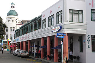
Napier is a city on the eastern coast of the North Island of New Zealand and the seat of the Hawke's Bay region. It is a beachside city with a seaport, known for its sunny climate, esplanade lined with Norfolk pines, and extensive Art Deco architecture. For these attributes, Napier is sometimes romantically referred to as the "Nice of the Pacific".

The 1931 Hawke's Bay earthquake, also known as the Napier earthquake, occurred in New Zealand at 10:47 am on 3 February, killing 256, injuring thousands and devastating the Hawke's Bay region. It remains New Zealand's deadliest natural disaster. Centred 15 km north of Napier, it lasted for two and a half minutes and had a magnitude of 7.8 . There were 525 aftershocks recorded in the following two weeks, with 597 being recorded by the end of February. The main shock could be felt in much of New Zealand, with reliable reports coming in from as far south as Timaru, on the east coast of the South Island.

Hastings is an inland city of New Zealand and is one of the two major urban areas in Hawke's Bay, on the east coast of the North Island. The population of Hastings is 51,500, with a further 15,200 people in Havelock North and 2,090 in Clive. Hastings is about 18 kilometres inland of the coastal city of Napier. These two neighbouring cities are often called "The Bay Cities" or "The Twin Cities".

British North America comprised the colonial territories of the British Empire in North America from 1783 onwards. English colonisation of North America began in the 16th century in Newfoundland, then further south at Roanoke and Jamestown, Virginia, and more substantially with the founding of the Thirteen Colonies along the Atlantic coast of North America.

Hawke Bay, formerly named Hawke's Bay, is a large bay on the east coast of the North Island of New Zealand, surrounded by the Hawke's Bay region. It stretches from Māhia Peninsula in the northeast to Cape Kidnappers / Te Kauwae-a-Māui in the southwest, a distance of some 90 kilometres (56 mi).

The Chatham Cup is New Zealand's premier knockout tournament in men's association football. It is held annually, with the final contested in September. The current champions of the Chatham Cup are 2023 winners Christchurch United, who defeated Melville United AFC on penalties in the final.

McLean Park is a sports ground in Napier, New Zealand. The two main sports played at the ground are cricket and rugby union. It is one of the largest cricket grounds in New Zealand.
Samuel David Jenkins is a New Zealand former footballer.
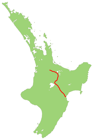
The Palmerston North–Gisborne Line (PNGL) is a secondary main line railway in the North Island of New Zealand. It branches from the North Island Main Trunk at Palmerston North and runs east through the Manawatū Gorge to Woodville, where it meets the Wairarapa Line, and then proceeds to Hastings and Napier in Hawke's Bay before following the coast north to Gisborne. Construction began in 1872, but the entire line was not completed until 1942. The line crosses the runway of Gisborne Airport, one of the world's few railways to do so since Pakistan's Khyber Pass Railway closed.
State Highway 5, one of New Zealand's eight national highways, runs from State Highway 1 at Tīrau, in the south Waikato, to State Highway 2, close to the Hawkes Bay coast at Bay View, 10 km north of Napier. It is the second shortest of the national highways.
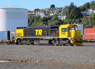
The Ahuriri Branch, now named the Napier Port Branch, is a 2 km railway branch line off the Palmerston North–Gisborne Line, in Napier, New Zealand. The branch serves the Port of Napier.
Crescent Island is a member of the Queen Elizabeth Islands and the Arctic Archipelago in the territory of Nunavut. It is an irregularly shaped island located at the northern mouth of the Penny Strait, and west of Napier Bay, Devon Island.

Park Island is the largest sports complex in Napier, New Zealand. It hosts clubs and facilities for association football (soccer), cricket, hockey, netball and rugby union. It includes Bluewater Stadium, a multi-purpose stadium that has a capacity of 5,000 people and opened in 1985. The stadium is used mostly for football matches and is the home stadium of Napier City Rovers and Hawke's Bay United. It also served as a training venue for teams in the 2011 Rugby World Cup.

Napier Rock is a rock lying 1.75 nautical miles (3.2 km) east-southeast of Point Thomas in Admiralty Bay, King George Island, in the South Shetland Islands. Charted by the French Antarctic Expedition under Charcot, 1908–10. Named by the United Kingdom Antarctic Place-Names Committee (UK-APC) in 1960 for Ronald G. Napier (1925–1956) of Falkland Islands Dependencies Survey (FIDS), general assistant and handyman at the Signy Island station in 1955, and then leader at Admiralty Bay until he was drowned on March 24, 1956.
The 2019 Chatham Cup is New Zealand's 92nd annual knockout football competition.

Napier City Council is the territorial authority of Napier, a city in the Hawke's Bay region of New Zealand's North Island.
The 2014 Chatham Cup was New Zealand's 87th annual knockout football competition.

The Hawke's Bay Regiment was a territorial infantry regiment of the New Zealand Military Forces. The regiment traced its origins to the Napier Rifle Volunteer Rifles, a volunteer corps formed in 1863 and which would later amalgamate with other volunteer corps to form the 9th Regiment in 1911. During the First World War, the regiment provided a company to each of the battalions of the Wellington Infantry Regiment and saw combat at Galipolli and on the Western Front. After the war the regiment was renamed the Hawke's Bay Regiment and remained in New Zealand for home defense during the Second World War. Men from the regiment, however, served with the 19th, 22nd, 25th and 36th Battalions of the Second New Zealand Expeditionary Force. The regiment had a close relationship with the Ruahine Regiment, which was detached and reabsorbed by the Hawke's Bay regiment on two separate occasions. In 1964, the Hawkes Bay regiment was amalgamated with the Wellington Regiment and become the 7th Battalion, Royal New Zealand Infantry Regiment
