
Canada has a vast geography that occupies much of the continent of North America, sharing a land border with the contiguous United States to the south and the U.S. state of Alaska to the northwest. Canada stretches from the Atlantic Ocean in the east to the Pacific Ocean in the west; to the north lies the Arctic Ocean. Greenland is to the northeast with a shared border on Hans Island. To the southeast Canada shares a maritime boundary with France's overseas collectivity of Saint Pierre and Miquelon, the last vestige of New France. By total area, Canada is the second-largest country in the world, after Russia. By land area alone, however, Canada ranks fourth, the difference being due to it having the world's largest proportion of fresh water lakes. Of Canada's thirteen provinces and territories, only two are landlocked while the other eleven all directly border one of three oceans.

The narwhal is a species of toothed whale native to the Arctic. It is the only member of the genus Monodon and one of two living representatives of the family Monodontidae. The narwhal has a similar build to the closely related beluga whale, with which it overlaps in range and can interbreed. It is a stocky cetacean, with a relatively blunt snout and large melon. Males of this species have a large 1.5–3.0 m long tusk, which is a left protruded canine thought to serve as a weapon or as a tool for feeding, attracting mates or sensing water salinity. Specially adapted slow-twitch muscles, along with the jointed neck vertebrae and shallow dorsal ridge allow for easy movement through the Arctic environment, where the narwhal spends extended periods at great depths.

Hudson Bay, sometimes called Hudson's Bay, is a large body of saltwater in northeastern Canada with a surface area of 1,230,000 km2 (470,000 sq mi). It is located north of Ontario, west of Quebec, northeast of Manitoba, and southeast of Nunavut, but politically entirely part of Nunavut. It is an inland marginal sea of the Arctic Ocean. The Hudson Strait provides a connection between the Labrador Sea and the Atlantic Ocean in the northeast, while the Foxe Channel connects the Hudson Bay with the Arctic Ocean in the north. The Hudson Bay drainage basin drains a very large area, about 3,861,400 km2 (1,490,900 sq mi), that includes parts of southeastern Nunavut, Alberta, Saskatchewan, Ontario, Quebec, all of Manitoba, and parts of the U.S. states of North Dakota, South Dakota, Minnesota, and Montana. Hudson Bay's southern arm is called James Bay.

Northern Canada, colloquially the North or the Territories, is the vast northernmost region of Canada, variously defined by geography and politics. Politically, the term refers to the three territories of Canada: Yukon, Northwest Territories and Nunavut. This area covers about 48 per cent of Canada's total land area, but has less than 0.5 per cent of Canada's population.
Frobisher Bay is an inlet of the Davis Strait in the Qikiqtaaluk Region of Nunavut, Canada. It is located in the southeastern corner of Baffin Island. Its length is about 230 km (140 mi) and its width varies from about 40 km (25 mi) at its outlet into the Davis Strait to roughly 20 km (12 mi) towards its inner end.

Baffin Bay, located between Baffin Island and the west coast of Greenland, is defined by the International Hydrographic Organization as a marginal sea of the Arctic Ocean. It is sometimes considered a sea of the North Atlantic Ocean. It is connected to the Atlantic via Davis Strait and the Labrador Sea. The narrower Nares Strait connects Baffin Bay with the Arctic Ocean. The bay is not navigable most of the year because of the ice cover and high density of floating ice and icebergs in the open areas. However, a polynya of about 80,000 km2 (31,000 sq mi), known as the North Water, opens in summer on the north near Smith Sound. Most of the aquatic life of the bay is concentrated near that region.

Devon Island is an island in Canada and the largest uninhabited island in the world. It is located in Baffin Bay, Qikiqtaaluk Region, Nunavut, Canada. It is one of the largest members of the Arctic Archipelago, the second-largest of the Queen Elizabeth Islands, Canada's sixth-largest island, and the 27th-largest island in the world. It has an area of 55,247 km2 (21,331 sq mi). The bedrock is Precambrian gneiss and Paleozoic siltstones and shales. The highest point is the Devon Ice Cap at 1,920 m (6,300 ft) which is part of the Arctic Cordillera. Devon Island contains several small mountain ranges, such as the Treuter Mountains, Haddington Range and the Cunningham Mountains. The notable similarity of its surface to that of Mars has attracted interest from scientists.

A member of the Arctic Archipelago, Prince Patrick Island is the westernmost of the Queen Elizabeth Islands in the Northwest Territories of Canada, lying northwest of Melville Island. The area of Prince Patrick Island is 15,848 km2 (6,119 sq mi), making it the 55th largest island in the world and Canada's 14th largest island. It has historically been icebound all year, making it one of the least accessible parts of Canada. Located at the entrance of the M'Clure Strait, Prince Patrick Island is uninhabited.

The Arctic char or Arctic charr is a cold-water fish in the family Salmonidae, native to alpine lakes, as well as Arctic and subarctic coastal waters in the Holarctic.

Foxe Basin is a shallow oceanic basin north of Hudson Bay, in Nunavut, Canada, located between Baffin Island and the Melville Peninsula. For most of the year, it is blocked by sea ice and drift ice made up of multiple ice floes.

Admiral Sir George Back was a British Royal Navy officer, explorer of the Canadian Arctic, naturalist and artist. He was born in Stockport.
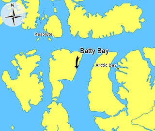
Batty Bay is a narrow bay in the Qikiqtaaluk Region, Nunavut, Canada. It is an arm of Prince Regent Inlet on the eastern side of Somerset Island.

HMS Terror was a specialised warship and a newly developed bomb vessel constructed for the Royal Navy in 1813. She participated in several battles of the War of 1812, including the Battle of Baltimore with the bombardment of Fort McHenry. She was converted into a polar exploration ship two decades later, and participated in George Back's Arctic expedition of 1836–1837, the successful Ross expedition to the Antarctic of 1839 to 1843, and Sir John Franklin's ill-fated attempt to force the Northwest Passage in 1845, during which she was lost with all hands along with HMS Erebus.
Innetalling Island is an uninhabited island in Qikiqtaaluk Region, Nunavut, Canada. Located in Hudson Bay's Omarolluk Sound, it is a member of the Belcher Islands group. It runs from Fairweather Sound at its northern end to Ridge Passage at its southern one. Fairweather Harbour is located on the north end of the island's east side.

Copper Inuit, also known as Inuinnait and Kitlinermiut, are a Canadian Inuit group who live north of the tree line, in what is now the Kitikmeot Region of Nunavut and in the Inuvialuit Settlement Region in the Inuvik Region of the Northwest Territories. Most of them historically lived in the area around Coronation Gulf, on Victoria Island, and southern Banks Island.

Hornaday River is a waterway located above the Arctic Circle on the mainland of Northern Canada.
Buchanan Bay is an Arctic waterway in Qikiqtaaluk Region, Nunavut, Canada. It is located in Nares Strait by eastern Ellesmere Island. The bay is bordered by Cape Camperdown on Bache Peninsula to the north, Cape Rutherford on Johan Peninsula to the south, and the Alexandra Fiord at its head.
Campbell Bay is an Arctic waterway in Kitikmeot Region, Nunavut, Canada. It is located on the south side of the Queen Maud Gulf, east of White Bear Point on Nunavut's mainland.
Gibson Bay is an arm of the Foxe Basin in the Qikiqtaaluk Region of Nunavut, Canada. It is located on the northern coast of Foxe Peninsula, in western Baffin Island. The closest community is Kinngait, situated 123 km (76 mi) to the south, while Nuwata, a former settlement, is situated 77 km (48 mi) to the west. It is fed by the Kommanik River whose headwaters are at Kavivan Lake, 5 mi (8.0 km) to the southeast. Within the bay, there is a small island chain.

The Canadian Arctic Rift System is a major North American geological structure extending from the Labrador Sea in the southeast through Davis Strait, Baffin Bay and the Arctic Archipelago in the northwest. It consists of a series of interconnected rifts that formed during the Paleozoic, Mesozoic and Cenozoic eras. Extensional stresses along the entire length of the rift system have resulted in a variety of tectonic features, including grabens, half-grabens, basins and faults.
