Related Research Articles

The Northwest Passage (NWP) is the sea lane between the Atlantic and Pacific oceans through the Arctic Ocean, along the northern coast of North America via waterways through the Arctic Archipelago of Canada. The eastern route along the Arctic coasts of Norway and Siberia is accordingly called the Northeast Passage (NEP). The various islands of the archipelago are separated from one another and from Mainland Canada by a series of Arctic waterways collectively known as the Northwest Passages, Northwestern Passages or the Canadian Internal Waters.

Hudson Strait in Nunavut links the Atlantic Ocean and the Labrador Sea to Hudson Bay in Canada. This strait lies between Baffin Island and Nunavik, with its eastern entrance marked by Cape Chidley in Newfoundland and Labrador and Nunavut and Resolution Island, off Baffin Island. The strait is about 750 km (470 mi) long with an average width of 125 km (78 mi), varying from 70 km (43 mi) at the eastern entrance to 240 km (150 mi) at Deception Bay.

Ellesmere Island is Canada's northernmost and third largest island, and the tenth largest in the world. It comprises an area of 196,236 km2 (75,767 sq mi), slightly smaller than Great Britain, and the total length of the island is 830 km (520 mi).

The Arctic Archipelago, also known as the Canadian Arctic Archipelago, is an archipelago lying to the north of the Canadian continental mainland, excluding Greenland and Iceland.

Baffin Bay, located between Baffin Island and the west coast of Greenland, is defined by the International Hydrographic Organization as a marginal sea of the Arctic Ocean. It is sometimes considered a sea of the North Atlantic Ocean. It is connected to the Atlantic via Davis Strait and the Labrador Sea. The narrower Nares Strait connects Baffin Bay with the Arctic Ocean. The bay is not navigable most of the year because of the ice cover and high density of floating ice and icebergs in the open areas. However, a polynya of about 80,000 km2 (31,000 sq mi), known as the North Water, opens in summer on the north near Smith Sound. Most of the aquatic life of the bay is concentrated near that region.
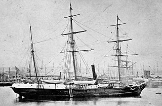
USSJeannette was a naval exploration vessel which, commanded by George W. De Long, undertook the Jeannette expedition of 1879–1881 to the Arctic. After being trapped in the ice and drifting for almost two years, the ship and her crew of 33 were released from the ice, then trapped again, crushed and sunk some 300 nautical miles north of the Siberian coast. The entire crew survived the sinking, but eight died while sailing towards land in a small cutter. The others reached Siberia, but 12 subsequently perished in the Lena Delta, including De Long.

Adolphus Washington Greely was a United States Army officer and polar explorer. He attained the rank of major general and was a recipient of the Medal of Honor.

The MacGregor Arctic Expedition was a privately funded expedition which set out to reoccupy Fort Conger, Ellesmere Island, Canada, a site within flying distance of the North Pole. The expedition, which took place from July 1, 1937, to October 3, 1938, had four main objectives: To collect weather data; to make a magnetic survey; to photograph the aurora borealis and study its effects upon radio transmission; and to explore the area northwest of Ellesmere Island, in order to clear up the questions about Crocker Land, which Robert Peary placed on the map more than 30 years earlier.

Pim Island is an uninhabited island located off the eastern coast of Ellesmere Island, part of the Qikiqtaaluk Region of the Canadian territory of Nunavut. Located within the Arctic Archipelago, it is a part of the Queen Elizabeth Islands.
Norman Lockyer Island is located off the eastern coast of Ellesmere Island, and a part of the Qikiqtaaluk Region of the Canadian territory of Nunavut. Situated in Princess Marie Bay just in front of Franklin Pierce Bay, 9 km (5.6 mi) WSW of Cape Prescott, north of Bache Peninsula, Norman Lockyer Island is within the Arctic Archipelago, a member of the Queen Elizabeth Islands.
Lady Franklin Bay is an Arctic waterway in the Qikiqtaaluk Region, Nunavut, Canada. The bay is located in Nares Strait, northwest of Judge Daly Promontory and is an inlet into the northeastern shore of Ellesmere Island.
The Simpson Strait is a natural, shallow waterway separating King William Island to the north from Adelaide Peninsula on Nunavut's mainland to the south. The strait, an arm of the Arctic Ocean, connects the Queen Maud Gulf with Rasmussen Basin's Rae Strait.

The Lady Franklin Bay Expedition of 1881–1884 to Lady Franklin Bay on Ellesmere Island in the Canadian Arctic was led by Lieutenant Adolphus Greely, and was promoted by the United States Army Signal Corps. Its purpose was to establish a meteorological-observation station as part of the First International Polar Year, and to collect astronomical and magnetic data. During the expedition, two members of the crew reached a new Farthest North record, but of the original twenty-five men, only seven survived to return.

HMS Alert was a 17-gun wooden screw sloop of the Cruizer class of the Royal Navy, launched in 1856 and broken up in 1894. She was the eleventh ship of the Royal Navy to bear the name, and was noted for her Arctic exploration work; in 1876 she reached a record latitude of 82° North. Alert briefly served with the US Navy, and ended her career with the Canadian Marine Service as a lighthouse tender and buoy ship.

Dobbin Bay is an Arctic waterway in the Qikiqtaaluk Region, Nunavut, Canada. It is located in the Kane Basin, Nares Strait by eastern Ellesmere Island, south of the Darling Peninsula.
Rosse Bay is an Arctic waterway in the Qikiqtaaluk Region, Nunavut, Canada. It is located in Nares Strait between Pim Island and Ellesmere Island's Johan Peninsula. The bay is also connected to Rice Strait.

Fort Conger is a former settlement, military fortification, and scientific research post in the Qikiqtaaluk Region, Nunavut, Canada. It was established in 1881 as an Arctic exploration camp, notable as the site of the first major northern polar region scientific expedition, the Lady Franklin Bay Expedition, led by Adolphus Greely as part of the United States government's contribution to the First International Polar Year. It was later occupied by Robert Peary during some of his Arctic expeditions.
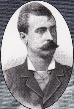
George Walter Rice was a Canadian photographer who was first to photograph the Arctic region on the ill-fated American led Lady Franklin Bay Expedition of 1881 to 1884. Rice died in the Arctic on 9 April 1884 while awaiting the arrival of a relief vessel.
The Jeannetteexpedition of 1879–1881, officially called the U.S. Arctic Expedition, was an attempt led by George W. De Long to reach the North Pole by pioneering a route from the Pacific Ocean through the Bering Strait. The premise was that a temperate current, the Kuro Siwo, flowed northwards into the strait, providing a gateway to the hypothesized Open Polar Sea and thus to the pole.
References
- ↑ Dieck, Herman Dieck (1885). The Marvellous Wonders of the Polar World. Philadelphia: Thompson National Pub. Co. pp. 521. OCLC 6878914.
cocked-hat rice's strait.
- ↑ The Photographic news. London: Cassell, Petter, and Galpin. 1858. pp. 639. OCLC 15044524.
arctic photographer greely rice.
- ↑ Buel, James William (1884). The world's wonders as seen by the great tropical and polar explorers : being an encyclopedia of exploration, discovery and adventure in all parts of the world ... St. Louis: Historical Pub. Co. pp. 584. OCLC 3569895.
George W. Rice Nova Scotia.
78°43′N074°43′W / 78.717°N 74.717°W
| | This Qikiqtaaluk Region, Nunavut location article is a stub. You can help Wikipedia by expanding it. |