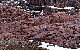
Pim Island

Last updated

Pim Island
Pim Island Arctica.jpg
2005 photo of Pim Island
Canada Nunavut location map-lambert proj3.svg
Red pog.svg
Pim Island
Canada location map 2.svg
Red pog.svg
Pim Island
Geography
Location Northern Canada
Coordinates 78°44′N074°25′W / 78.733°N 74.417°W / 78.733; -74.417 (Pim Island)
Archipelago Queen Elizabeth Islands
Arctic Archipelago
Administration
Canada
Territory Nunavut
Region Qikiqtaaluk
Demographics
PopulationUninhabited
Plaque on Pim Island to the memory of dead men from the expedition of Adolphus Greely. Photographed in 2005 Adolphus Greely men memorial.jpg
Plaque on Pim Island to the memory of dead men from the expedition of Adolphus Greely. Photographed in 2005

Pim Island (previously Bedford Pim Island) [1] is an uninhabited island located off the eastern coast of Ellesmere Island, part of the Qikiqtaaluk Region of the Canadian territory of Nunavut. Located within the Arctic Archipelago, it is a part of the Queen Elizabeth Islands.

Contents

Pim Island is separated from Ellesmere Island by Rice Strait, the waterway that connects Rosse Bay to the south and Buchanan Bay to the north. [2] Nares Strait is to the east. Pim Island is 6 kilometres (3.7 mi) from Cocked Hat Island.

History

The Adolphus Greely expedition wintered at Camp Clay in 1883, [3] and in 1884, Cape Sabine was the rescue site for Greely and the Lady Franklin Bay Expedition. [4] The island is named in honour of naval officer and barrister Bedford Pim of HMS Resolute.

Related Research Articles

<span class="mw-page-title-main">Ellesmere Island</span> Island of the Arctic Archipelago in Nunavut, Canada

Ellesmere Island is Canada's northernmost and third largest island, and the tenth largest in the world. It comprises an area of 196,236 km2 (75,767 sq mi), slightly smaller than Great Britain, and the total length of the island is 830 km (520 mi).

<span class="mw-page-title-main">Baffin Bay</span> Marginal sea between Greenland and Baffin Island, Canada

Baffin Bay, located between Baffin Island and the west coast of Greenland, is defined by the International Hydrographic Organization as a marginal sea of the Arctic Ocean. It is sometimes considered a sea of the North Atlantic Ocean. It is connected to the Atlantic via Davis Strait and the Labrador Sea. The narrower Nares Strait connects Baffin Bay with the Arctic Ocean. The bay is not navigable most of the year because of the ice cover and high density of floating ice and icebergs in the open areas. However, a polynya of about 80,000 km2 (31,000 sq mi), known as the North Water, opens in summer on the north near Smith Sound. Most of the aquatic life of the bay is concentrated near that region.

<span class="mw-page-title-main">Adolphus Greely</span> American polar explorer and army general (1844–1935)

Adolphus Washington Greely was a United States Army officer and polar explorer. He attained the rank of major general and was a recipient of the Medal of Honor.

<span class="mw-page-title-main">Smith Sound</span> Arctic sea passage between Greenland and Canada

Smith Sound is an Arctic sea passage between Greenland and Nunavut's northernmost island, Ellesmere Island. It links Baffin Bay with Kane Basin and forms part of the Nares Strait. On the Canadian side it extends from Cape Sabine in the north to Cape Isabella in the south.

<span class="mw-page-title-main">Kane Basin</span> Arctic waterway lying between Greenland and Canada

Kane Basin is an Arctic waterway lying between Greenland and Canada's northernmost island, Ellesmere Island. It links Smith Sound to Kennedy Channel and forms part of Nares Strait. It is approximately 180 kilometres in length and 130 km at its widest.

<span class="mw-page-title-main">Francis Crozier</span> Irish naval officer and polar explorer (1796–1848?)

Francis Rawdon Moira Crozier was an Irish officer of the Royal Navy and polar explorer who participated in six expeditions to the Arctic and Antarctic. In May 1845, he was second-in-command to Sir John Franklin and captain of HMS Terror during the Franklin expedition to discover the Northwest Passage, which ended with the loss of all 129 crewmen in mysterious circumstances.

Cape Sabine is a land point on Pim Island, off the eastern shores of the Johan Peninsula, Ellesmere Island, in the Smith Sound, Qikiqtaaluk Region, Nunavut, Canada.

Cocked Hat Island, located off the eastern coast of Ellesmere Island, is a part of the Qikiqtaaluk Region of the Canadian territory of Nunavut. The island is located within the Arctic Archipelago, and is a part of the Queen Elizabeth Islands.

Rice Strait is a narrow waterway between Ellesmere Island's eastern coast and Pim Island in northern Canada's territory of Nunavut. It connects Rosse Bay on the south with Buchanan Bay to the north.

Norman Lockyer Island is located off the eastern coast of Ellesmere Island, and a part of the Qikiqtaaluk Region of the Canadian territory of Nunavut. Situated in Princess Marie Bay just in front of Franklin Pierce Bay, 9 km (5.6 mi) WSW of Cape Prescott, north of Bache Peninsula, Norman Lockyer Island is within the Arctic Archipelago, a member of the Queen Elizabeth Islands.

<span class="mw-page-title-main">Lady Franklin Bay Expedition</span> Polar expedition

The Lady Franklin Bay Expedition of 1881–1884 to Lady Franklin Bay on Ellesmere Island in the Canadian Arctic was led by Lieutenant Adolphus Greely, and was promoted by the United States Army Signal Corps. Its purpose was to establish a meteorological-observation station as part of the First International Polar Year, and to collect astronomical and magnetic data. During the expedition, two members of the crew reached a new Farthest North record, but of the original twenty-five men, only seven survived to return.

HMS <i>Alert</i> (1856) 19th-century British Royal Navy sloop

HMS Alert was a 17-gun wooden screw sloop of the Cruizer class of the Royal Navy, launched in 1856 and broken up in 1894. She was the eleventh ship of the Royal Navy to bear the name, and was noted for her Arctic exploration work; in 1876 she reached a record latitude of 82° North. Alert briefly served with the US Navy, and ended her career with the Canadian Marine Service as a lighthouse tender and buoy ship.

Dobbin Bay is an Arctic waterway in Qikiqtaaluk Region, Nunavut, Canada. It is located in Nares Strait by eastern Ellesmere Island, south of the Darling Peninsula.

Rosse Bay is an Arctic waterway in Qikiqtaaluk Region, Nunavut, Canada. It is located in Nares Strait between Pim Island and Ellesmere Island's Johan Peninsula. The bay is also connected to Rice Strait.

Herschel Bay is an Arctic waterway in Qikiqtaaluk Region, Nunavut, Canada. It is located in Nares Strait, west of Smith Sound. Ellesmere Island is to the east, while Pim Island's Cape Sabine is to the northeast.

<span class="mw-page-title-main">Fort Conger</span> Former settlement in Nunavut, Canada

Fort Conger is a former settlement, military fortification, and scientific research post in the Qikiqtaaluk Region, Nunavut, Canada. It was established in 1881 as an Arctic exploration camp, notable as the site of the first major northern polar region scientific expedition, the Lady Franklin Bay Expedition, led by Adolphus Greely as part of the United States government's contribution to the First International Polar Year. It was later occupied by Robert Peary during some of his Arctic expeditions.

<span class="mw-page-title-main">Tanquary Fiord</span> Fjord on Ellesmere Island, Nunavut, Canada

Tanquary Fiord is a fjord on the north coast of the Arctic Archipelago's Ellesmere Island, Nunavut, Canada. It is located in the Quttinirpaaq National Park and extends 48 km (30 mi) in a north-westerly direction from Greely Fiord.

<span class="mw-page-title-main">George W. Rice (photographer)</span> Canadian photographer (1855–1884)

George Walter Rice was a British North America-born photographer who was first to photograph the Arctic region on the ill-fated American led Lady Franklin Bay Expedition of 1881 to 1884. Rice died in the Arctic on 9 April 1884 while awaiting the arrival of a relief vessel.

References

  1. Greely, A. W. (2007). Handbook of Polar Discoveries. Read Books. p. 238. ISBN   978-1-4067-6645-5.
  2. Dieck, Herman Dieck (1885). The Marvellous Wonders of the Polar World. Philadelphia: Thompson National Pub. Co. pp.  521. OCLC   6878914. cocked-hat rice's strait.
  3. Dick, Lyle (2001). Muskox land: Ellesmere Island in the age of contact. University of Calgary Press. p. 281. ISBN   1-55238-050-5.
  4. Guttridge, Leonard F. (2000-09-01). "Ghosts of Cape Sabine: the harrowing true story of the Greely expedition". Arctic Institute of North America of the University of Calgary. Retrieved 2008-04-14.