
The Northwest Passage (NWP) is the sea route between the Atlantic and Pacific oceans through the Arctic Ocean, along the northern coast of North America via waterways through the Canadian Arctic Archipelago. The eastern route along the Arctic coasts of Norway and Siberia is accordingly called the Northeast Passage (NEP). The various islands of the archipelago are separated from one another and from Mainland Canada by a series of Arctic waterways collectively known as the Northwest Passages, Northwestern Passages or the Canadian Internal Waters.
Sir William Edward Parry was an Royal Navy officer and explorer best known for his 1819–1820 expedition through the Parry Channel, probably the most successful in the long quest for the Northwest Passage, until it was finally negotiated by Roald Amundsen in 1906. In 1827, Parry attempted one of the earliest expeditions to the North Pole. He reached 82° 45' N, setting a record for human exploration Farthest North that stood for nearly five decades before being surpassed at 83° 20' N by Albert Hastings Markham in 1875.

Sir John Ross was a Scottish Royal Navy officer and polar explorer. He was the uncle of Sir James Clark Ross, who explored the Arctic with him, and later led expeditions to Antarctica.

Sir John Franklin was a British Royal Navy officer and Arctic explorer. After serving in wars against Napoleonic France and the United States, he led two expeditions into the Canadian Arctic and through the islands of the Arctic Archipelago, in 1819 and 1825, and served as Lieutenant-Governor of Van Diemen's Land from 1839 to 1843. During his third and final expedition, an attempt to traverse the Northwest Passage in 1845, Franklin's ships became icebound off King William Island in what is now Nunavut, where he died in June 1847. The icebound ships were abandoned ten months later and the entire crew died, from causes such as starvation, hypothermia, and scurvy.

Melville Island is an uninhabited member of the Queen Elizabeth Islands of the Arctic Archipelago. With an area of 42,149 km2 (16,274 sq mi), It is the 33rd largest island in the world and Canada's eighth largest island.

Somerset Island is a large, uninhabited island of the Arctic Archipelago, that is part of the Canadian territory of Nunavut. The island is separated from Cornwallis Island and Devon Island to the north by the Parry Channel, from Baffin Island to the east by Prince Regent Inlet, from the Boothia Peninsula to the south by Bellot Strait, and from Prince of Wales Island to the west by Peel Sound. It has an area of 24,786 km2 (9,570 sq mi), making it the 46th largest island in the world and Canada's twelfth largest island.

Bathurst Island is one of the Queen Elizabeth Islands in Nunavut, Canada. It is a member of the Arctic Archipelago. The area of the island is estimated at 16,042 km2 (6,194 sq mi), 115 to 117 mi long and from 63 mi (101 km) to 72 mi (116 km) to 92.9 mi (149.5 km) wide, making it the 54th largest island in the world and Canada's 13th largest island. It is uninhabited.

Russell Island is an uninhabited island of the Arctic Archipelago in the Qikiqtaaluk Region of Nunavut, Canada. It is located in the Parry Channel, separated from the northern tip of Prince of Wales Island by the narrow Baring Channel. The western third of the island is separated from the other two thirds by a narrow lake and its outlet. At the northern end of the lake there is an isthmus just 1.1 km (0.68 mi) wide and this joins the two parts of the island. With a total area of 940 km2 (360 sq mi), it is the largest island offshore of Prince of Wales Island.

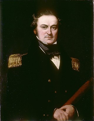
Sir Francis Leopold McClintock was an Irish explorer in the British Royal Navy, known for his discoveries in the Canadian Arctic Archipelago. He confirmed explorer John Rae's controversial report gathered from Inuit sources on the fate of Franklin's lost expedition, the ill-fated Royal Navy undertaking commanded by Sir John Franklin in 1845 attempting to be the first to traverse the Northwest Passage.
Beechey Island is an island located in the Arctic Archipelago of Nunavut, Canada, in Wellington Channel. It is separated from the southwest corner of Devon Island by Barrow Strait. Other features include Wellington Channel, Erebus Harbour, and Terror Bay.

Prince Regent Inlet is a body of water in Nunavut, Canada between the west end of Baffin Island and Somerset Island on the west. It opens north into Lancaster Sound and to the south merges into the Gulf of Boothia. The Arctic inlet's northern portion is approximately 40 mi (64 km) wide; the southern portion is approximately 65 mi (105 km) wide. It is deep throughout and there are no islands within the inlet.

Fury and Hecla Strait is a narrow Arctic seawater channel located in the Qikiqtaaluk Region of Nunavut, Canada.

Prince Leopold Island is an island in the Qikiqtaaluk Region of Nunavut, Canada. It is located in Lancaster Sound at the junction of Prince Regent Inlet and Barrow Strait. Somerset Island is situated 13 km (8.1 mi) to the southwest; Port Leopold, an abandoned trading post, is the closest landmark. The island is significant as a summer habitat and breeding ground for large populations of several arctic bird species.

Franklin's lost expedition was a failed British voyage of Arctic exploration led by Captain Sir John Franklin that departed England in 1845 aboard two ships, HMS Erebus and HMS Terror, and was assigned to traverse the last unnavigated sections of the Northwest Passage in the Canadian Arctic and to record magnetic data to help determine whether a better understanding could aid navigation. The expedition met with disaster after both ships and their crews, a total of 129 officers and men, became icebound in Victoria Strait near King William Island in what is today the Canadian territory of Nunavut. After being icebound for more than a year Erebus and Terror were abandoned in April 1848, by which point Franklin and nearly two dozen others had died. The survivors, now led by Franklin's second-in-command, Francis Crozier, and Erebus's captain, James Fitzjames, set out for the Canadian mainland and disappeared, presumably having perished.

Barrow Strait is a shipping waterway in Northern Canada's territory of Nunavut. Forming part of the Parry Channel, the strait separates several large islands including Cornwallis Island and Devon Island to the north, from Prince of Wales Island, Somerset Island, and Prince Leopold Island to the south.
Griffith Island lies within the Arctic Archipelago in the Qikiqtaaluk Region of northern Canada's territory of Nunavut. It is one of the mid-channel islands in the western sector of Barrow Strait.

The Parry Channel is a natural waterway through the central Canadian Arctic Archipelago. Its eastern two-thirds lie in the territory of Nunavut, while its western third lies in the Northwest Territories. It runs east to west, connecting Baffin Bay in the east with the Beaufort Sea in the west. Its eastern end is the only practical entrance to the Northwest Passage. Its western end would be a natural exit from the archipelago were it not filled with ice. The channel separates the Queen Elizabeth Islands to the north from the rest of Nunavut.
Captain Henry Parkyns Hoppner was an officer of the Royal Navy, Arctic explorer, draughtsman and artist. His career included two ill-fated voyages culminating in the loss of HMS Alceste in 1816 and HMS Fury in 1825.

The McClure Arctic expedition of 1850, among numerous British search efforts to determine the fate of the Franklin's lost expedition, is distinguished as the voyage during which the Irish explorer Robert McClure became the first person to confirm and transit the Northwest Passage by a combination of sea travel and sledging.

