
Robert Joseph Flaherty, was an American filmmaker who directed and produced the first commercially successful feature-length documentary film, Nanook of the North (1922). The film made his reputation and nothing in his later life fully equaled its success, although he continued the development of this new genre of narrative documentary with Moana (1926), set in the South Seas, and Man of Aran (1934), filmed in Ireland's Aran Islands. Flaherty is considered the father of both the documentary and the ethnographic film.

Baffin Island, in the Canadian territory of Nunavut, is the largest island in Canada and the fifth-largest island in the world. Its area is 507,451 km2 (195,928 sq mi) with a population density of 0.03/km²; the population was 13,039 according to the 2021 Canadian census; and it is located at 68°N70°W. It also contains the city of Iqaluit, which is the capital of Nunavut.

Victoria Island is a large island in the Arctic Archipelago that straddles the boundary between Nunavut and the Northwest Territories of Canada. It is the eighth-largest island in the world, and at 217,291 km2 (83,897 sq mi) in area, it is Canada's second-largest island. It is nearly double the size of Newfoundland (111,390 km2 [43,010 sq mi]), and is slightly larger than the island of Great Britain (209,331 km2 [80,823 sq mi]) but smaller than Honshu (225,800 km2 [87,200 sq mi]). The western third of the island lies in the Inuvik Region of the Northwest Territories; the remainder is part of Nunavut's Kitikmeot Region. The population of 2,168 is divided among two settlements, the larger of which is in Nunavut and the other of which is in the Northwest Territories.
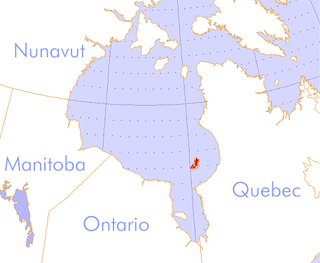
The Belcher Islands are an archipelago in the southeast part of Hudson Bay near the centre of the Nastapoka arc. The Belcher Islands are spread out over almost 3,000 km2 (1,200 sq mi). Administratively, they belong to the Qikiqtaaluk Region of Nunavut, Canada. The hamlet of Sanikiluaq is on the north coast of Flaherty Island and is the southernmost in Nunavut. Along with Flaherty Island, the other large islands are Kugong Island, Tukarak Island, and Innetalling Island. Other main islands in the 1,500–island archipelago are Moore Island, Wiegand Island, Split Island, Snape Island and Mavor Island, while island groups include the Sleeper Islands, King George Islands, and Bakers Dozen Islands.
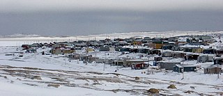
Sanikiluaq is a municipality and Inuit community located on the north coast of Flaherty Island in Hudson Bay, on the Belcher Islands. Despite being geographically much closer to the shores of Ontario and Quebec, the community and the Belcher Islands lie within the Qikiqtaaluk Region of Nunavut, Canada.

Mansel Island, a member of the Arctic Archipelago, is an uninhabited island in Qikiqtaaluk Region, Nunavut. It is located in Hudson Bay off of Quebec's Ungava Peninsula. At 3,180 km2 (1,230 sq mi) in size, it is the 159th largest island in the world, and Canada's 28th largest island. Its topography features a gently undulating limestone lowland with elevations not exceeding 100 m.

Coral Harbour is a small Inuit community that is located on Southampton Island, Kivalliq Region, in the Canadian territory of Nunavut. Its name is derived from the fossilized coral that can be found around the waters of the community which is situated at the head of South Bay. The name of the settlement in Inuktitut is Salliq, sometimes used to refer to all of Southampton Island. The plural Salliit, means large flat island(s) in front of the mainland.

Kimmirut is a community in the Qikiqtaaluk Region, Nunavut, Canada. It is located on the shore of Hudson Strait on Baffin Island's Meta Incognita Peninsula. Kimmirut means "heel", and refers to a rocky outcrop in the inlet.
Moore Island is an uninhabited island in the Qikiqtaaluk Region, Nunavut, Canada. It is a member of the Belcher Islands group in Hudson Bay. It lies in Churchill Sound between Kugong Island to its west and the Howard Peninsula of Flaherty Island to its east with the Inuit community of Sanikiluaq about 30 km (19 mi) northeast.
Tukarak Island is an uninhabited island in Qikiqtaaluk Region, Nunavut, Canada. Located in Hudson Bay, it is a member of the Belcher Islands group. Along with Flaherty Island, Innetalling Island, and Kugong Island, it is one of the four large islands in the group.

Nunavut is the largest and northernmost territory of Canada. It was separated officially from the Northwest Territories on April 1, 1999, via the Nunavut Act and the Nunavut Land Claims Agreement Act, which provided this territory to the Inuit for independent government. The boundaries had been drawn in 1993. The creation of Nunavut resulted in the first major change to Canada's political map in half a century since the province of Newfoundland was admitted in 1949.
Qikiqtaaluk, Unorganized in Nunavut, Canada, is part of a larger census division known as the Qikiqtaaluk Region. This area covers the whole Qikiqtaaluk Region outside the 13 communities such as Iqaluit, Resolute or Grise Fiord. Baffin has a rocky mountainous landscape. Prior to the 2021 Canadian census it was known as Baffin.
Big Island is a small, uninhabited island located in Hudson Bay near the community of Puvirnituq, Quebec, Canada. The island, one of three islands named "Big Island" in the Qikiqtaaluk Region of Nunavut, is part of the Arctic Archipelago.
Dundas Island is a member of the Queen Elizabeth Islands and the Arctic Archipelago in the territory of Nunavut. It is an irregularly shaped island located between Devon Island and Baillie-Hamilton Island. The smaller Margaret Island is 1 km (0.62 mi) to the east of Dundas.
Opingivik Island is an uninhabited Baffin Island offshore island located in the Arctic Archipelago in Nunavut's Qikiqtaaluk Region. It lies in Cumberland Sound between Ikpit Bay to the north and Robert Peel Inlet approximately 18.6 km (11.6 mi) to the south.
Grey Goose Island is one of several, larger, uninhabited Canadian arctic islands in Nunavut, Canada located within the midsection of James Bay. Other comparable islands in the area include the Bear Islands, North and South Twin Islands, Spencer Island, Sunday Island, and Walter Island. La Grande River and the Cree village of Chisasibi, Quebec are 65 km (40 mi) to the southeast.
The Strutton Islands are an uninhabited Canadian arctic islands group located within the midsection of James Bay in Nunavut, Canada. They are situated south of Vieux-Comptoir.
The Salikuit Islands are an uninhabited island group in the Qikiqtaaluk Region of Nunavut, Canada. The 103 island archipelago is located in eastern Hudson Bay between the Belcher Islands and the western coast of Quebec. The closest communities are the Inuit hamlets of Umiujaq, Quebec, 60 km to the east on the coast of Hudson Bay, and Sanikiluaq, 75 km (47 mi) to the west on Flaherty Island.
Mini Aodla Freeman is an Inuk playwright, writer, poet and essayist.


