Digges Islands

Last updated
Digges Islands
Native name:
Saaqqayaaq-Qikirtasiit
Digges Sound.png
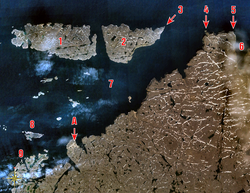
Digges Islands identified by No. 1 and 2.
Canada Nunavut location map-lambert proj3.svg
Red pog.svg
Digges Islands
Canada location map 2.svg
Red pog.svg
Digges Islands
Geography
Location Digges Sound, an arm of Hudson Bay
Coordinates 62°34′59″N77°49′59″W / 62.58306°N 77.83306°W / 62.58306; -77.83306 (Digges Islands) Coordinates: 62°34′59″N77°49′59″W / 62.58306°N 77.83306°W / 62.58306; -77.83306 (Digges Islands)
Archipelago Arctic Archipelago
Area91 km2 (35 sq mi)
Administration
Canada
Nunavut Nunavut
Region Qikiqtaaluk
Demographics
PopulationUninhabited

The Digges Islands [1] (Inuit: Saaqqayaaq-Qikirtasiit) [2] are members of the Arctic Archipelago in the territory of Nunavut. The two islands, West Digges and East Digges, are located in Digges Sound, an arm of Hudson Bay, where the strong currents of the bay meet Hudson Strait.

Contents

The hamlet of Ivujivik, on the Ungava Peninsula, is south of the islands. East Digges Island is closer to the northern tip of the Ungava Peninsula than West Digges. Mansel Island is to the southwest, while Nottingham Island is to the north.

The islands' rocky cliffs topography is ideal for seabirds; thick-billed murre colonies are abundant.

Arctic exploration

In 1610, the first recorded encounter between Europeans and Nunavik Inuit occurred on Digges Islands during Henry Hudson's last expedition. [3] Hudson named many Arctic points after patrons who financed the voyage, including Dudley Digges, the namesake of the Digges Islands. In 1611 four of Hudson's mutineers were killed here by Inuit and in 1612 Thomas Button had five of his crew killed somewhere near the Islands.

The area was explored again soon after by Jens Munk during his 1619 voyage. [4]

Henry Hudson's map depicting location of Digges Islands in the far west. Henry Hudson map.JPG
Henry Hudson's map depicting location of Digges Islands in the far west.

Related Research Articles

Nunavik Proposed autonomous area in Quebec, Canada

Nunavik comprises the northern third of the province of Quebec, part of the Nord-du-Québec region and nearly coterminous with Kativik. Covering a land area of 443,684.71 km2 (171,307.62 sq mi) north of the 55th parallel, it is the homeland of the Inuit of Quebec and part of the wider Inuit Nunangat. Almost all of the 13,181 inhabitants of the region, of whom 90% are Inuit, live in fourteen northern villages on the coast of Nunavik and in the Cree reserved land (TC) of Whapmagoostui, near the northern village of Kuujjuarapik.

Inuksuk Type of manmade stone landmark or cairn

An inuksuk or inukshuk is a manmade stone landmark or cairn built for use by the Inuit, Iñupiat, Kalaallit, Yupik, and other peoples of the Arctic region of North America. These structures are found in northern Canada, Greenland, and Alaska. This combined region, north of the Arctic Circle, is dominated by the tundra biome and has areas with few natural landmarks.

Ungava Peninsula

The Ungava Peninsula of Nunavik, Quebec, Canada, is bounded by Hudson Bay to the west, Hudson Strait to the north, and Ungava Bay to the east. This peninsula is part of the Labrador Peninsula, and covers about 252,000 square kilometres (97,000 sq mi). Its northernmost point is Cape Wolstenholme, which is also the northernmost point of Quebec. The peninsula is also part of the Canadian Shield, and consists entirely of treeless tundra dissected by large numbers of rivers and glacial lakes, flowing generally east–west in a parallel fashion. The peninsula was not deglaciated until 6,500 years ago and is believed to have been the prehistoric centre from which the vast Laurentide Ice Sheet spread over most of North America during the last glacial epoch.

Southampton Island

Southampton Island is a large island at the entrance to Hudson Bay at Foxe Basin. One of the larger members of the Arctic Archipelago, Southampton Island is part of the Kivalliq Region in Nunavut, Canada. The area of the island is stated as 41,214 km2 (15,913 sq mi) by Statistics Canada. It is the 34th largest island in the world and Canada's ninth largest island. The only settlement on Southampton Island is Coral Harbour, called Salliq in Inuktitut.

Kuujjuaq Northern village municipality in Quebec, Canada

Kuujjuaq, formerly known as Fort Chimo and by other names, is a former Hudson's Bay Company outpost at the mouth of the Koksoak River on Ungava Bay that has become the largest northern village in the Nunavik region of Quebec, Canada. It is the administrative capital of the Kativik Regional Government. Its population was 2,668 as of the 2021 census.

Ungava Bay

Ungava Bay is a bay in northeastern Canada separating Nunavik from Baffin Island. Although not geographically apparent, it is considered to be a marginal sea of the Arctic Ocean for climatic reasons. The bay is roughly oval-shaped, about 260 km (160 mi) at its widest point and about 320 km (200 mi) in length; it has an area of approximately 50,000 km2 (19,000 sq mi). It is generally fairly shallow, under 150 m (490 ft), though at its border with the Atlantic Ocean depths of almost 300 m (980 ft) are reached.

District of Ungava

The District of Ungava was a regional administrative district of Canada's Northwest Territories from 1895 to 1920, although it effectively ceased operation in 1912. It covered the northern portion of what is today Quebec, the interior of Labrador, and the offshore islands to the west and north of Quebec, which are now part of Nunavut.

Ivujivik Northern village municipality in Quebec, Canada

Ivujivik is a northern village in Nunavik, Quebec, and the northernmost settlement in any Canadian province, although there are settlements further north in the territories. Its population in the Canada 2021 Census was 412. Unlike most other northern villages in Nunavik, it has no Inuit reserved land of the same name associated with it.

Rasmus Jensen (priest)

Rasmus Jensen was a Danish Lutheran priest and the first Lutheran cleric in Canada.

The Canadian territory of Nunavut covers about 1.9 million square kilometres of land and water including part of the mainland, most of the Arctic islands, and all of the islands in Hudson Bay, James Bay, and Ungava Bay which belonged to the Northwest Territories. This makes it the fifth largest country subdivision in the world. If Nunavut were a country, it would rank 13th in area, after the Democratic Republic of the Congo. Nunavut has land borders with Manitoba, the Northwest Territories on several islands as well as the mainland, and a tiny land border with Newfoundland and Labrador on Killiniq Island.

Nunavut Territory of Canada

Nunavut is the largest and northernmost territory of Canada. It was separated officially from the Northwest Territories on April 1, 1999, via the Nunavut Act and the Nunavut Land Claims Agreement Act, which provided this territory to the Inuit for independent government. The boundaries had been drawn in 1993. The creation of Nunavut resulted in the first major change to Canada's political map in half a century since the province of Newfoundland was admitted in 1949.

The Ottawa Islands are a group of currently uninhabited islands situated in the eastern edge of Canada's Hudson Bay. The group comprises 24 small islands, located at approximately 60N 80W. The main islands include Booth Island, Bronson Island, Eddy Island, Gilmour Island, J. Gordon Island, Pattee Island, and Perley Island. The highest point is on Gilmour Island, which rises to over 1,800 ft (550 m). Located a short distance off the northwest coast of Quebec's Ungava Peninsula, they, like the other coastal islands in Hudson Bay, were historically part of the Northwest Territories, and became Crown Land upon the creation of Nunavut in 1999. Nunavik Inuit have occupied these islands since time immemorial and gained constitutionally-protected harvest and access rights under the Nunavik Inuit Land Claim Agreement signed in 2007.

Nuvuk Islands

The uninhabited Nuvuk Islands, members of the Arctic Archipelago, are located in the Hudson Bay, at the western outlet of Digges Sound, just west of the Ungava Peninsula. The island group is a part of the Qikiqtaaluk Region, in the Canadian territory of Nunavut.

George River (Quebec) River in Quebec, Canada.

George River, formerly the East or George's River, is a river in northeastern Quebec, Canada, that flows from Lake Jannière mainly north to Ungava Bay.

Digges Sound Arctic waterway in Qikiqtaaluk, Nunavut, Canada

Digges Sound is a Canadian Arctic waterway in Qikiqtaaluk, Nunavut, Canada. The sound is located at the juncture where the Hudson Strait meets northeastern Hudson Bay close to the northern tip of the Ungava Peninsula, between Digges Islands and Cape Wolstenholme. Ivujivik, Quebec, the northernmost settlement in any Canadian province, is located on the south coast of the sound.

Kangirsuk Northern village municipality in Quebec, Canada

Kangirsuk is an Inuit village in northern Nunavik, Quebec, Canada. It is 230 kilometres (140 mi) north of Kuujjuaq, between Aupaluk and Quaqtaq. The community is only accessible by air and, in late summer, by boat. The village used to be known also as Payne Bay and Bellin.

Cape Wolstenholme Cape and northernmost point in Quebec, Canada

Cape Wolstenholme is a cape and is the extreme northernmost point of the province of Quebec, Canada. Located on the Hudson Strait, about 28 kilometres (17 mi) north-east of Quebec's northernmost settlement of Ivujivik, it is also the northernmost tip of the Ungava Peninsula, which is in turn the northernmost part of the Labrador Peninsula.

The Gyrfalcon Islands are an uninhabited island group in the Qikiqtaaluk Region of Nunavut, Canada. The over 200 small islands form an archipelago in western Ungava Bay north of Quebec's Ungava Peninsula and 19.7 km (12.2 mi) northeast of Leaf Bay. Tiercel Island and Qikirtajuaq Island lie to the southwest. The closest community is the Inuit village of Kuujjuaq, 120 km (75 mi) to the southeast.

Killiniq is a former Inuit settlement, weather station, trading post, missionary post, fishing station, and Royal Canadian Mounted Police post on Killiniq Island. Previously within Labrador, and then the Northwest Territories, it is now situated within the borders of Nunavut. The community closed in 1978.

Whaling in Canada encompasses both aboriginal and commercial whaling, and has existed on all three Canadian oceans, Atlantic, Pacific, and Arctic. The indigenous peoples of the Pacific Northwest Coast have whaling traditions dating back millennia, and the hunting of cetaceans continues by Inuit. Commercial whaling was one of the stimuli for Europeans to explore the sub-Arctic and Arctic, possibly as early as the 14th century. By the late 20th century, watching whales was a more profitable enterprise than hunting them.

References

  1. "285 - Digges Islands, Nunavut". Atlas of Canada. Archived from the original on 2012-07-01. Retrieved 2008-06-10.
  2. Issenman, Betty. Sinews of Survival: The living legacy of Inuit clothing. UBC Press, 1997. pp252-254
  3. "ATTRACTIONS". nunavik-tourism.com. Archived from the original on 2015-05-22. Retrieved 2008-06-22.
  4. "MUNK (Munck), JENS ERIKSEN, Danish". Dictionary of Canadian Biography Online. Retrieved 2008-06-22.