Nuvuk Islands

Last updated
Nuvuk Islands
Digges Sound.png
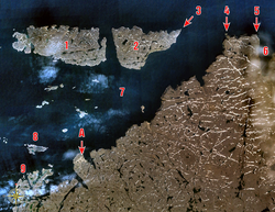
Nuvuk Islands in the lower left corner (identified with No. 9).
Canada Nunavut location map-lambert proj3.svg
Red pog.svg
Nuvuk Islands
Canada location map 2.svg
Red pog.svg
Nuvuk Islands
Geography
Location Hudson Bay
Coordinates 62°24′N078°03′W / 62.400°N 78.050°W / 62.400; -78.050 (Nuvuk Islands) Coordinates: 62°24′N078°03′W / 62.400°N 78.050°W / 62.400; -78.050 (Nuvuk Islands)
Archipelago Arctic Archipelago
Administration
Canada
Territory Nunavut
Region Qikiqtaaluk
Demographics
PopulationUninhabited
Source: Nuvuk Islands at Atlas of Canada

The uninhabited Nuvuk Islands, members of the Arctic Archipelago, are located in the Hudson Bay, at the western outlet of Digges Sound, just west of the Ungava Peninsula. The island group is a part of the Qikiqtaaluk Region, in the Canadian territory of Nunavut. [1]

Related Research Articles

Inuit languages Language family

The Inuit languages are a closely related group of indigenous American languages traditionally spoken across the North American Arctic and adjacent subarctic, reaching farthest south in Labrador. The related Yupik languages are the two main branches of Eskaleut, a primary language family. The Inuit live primarily in three countries: Greenland, Canada, and the United States.

Baffin Island Large Arctic island in Nunavut, Canada

Baffin Island, in the Canadian territory of Nunavut, is the largest island in Canada and the fifth-largest island in the world. Its area is 507,451 km2 (195,928 sq mi)—slightly larger than Spain, its population was 13,039 as of the 2021 Canadian census, and is located at 68°N70°W. It also contains the city of Iqaluit, the capital of Nunavut.

Grise Fiord Hamlet in Nunavut, Canada

Grise Fiord is an Inuit hamlet on the southern tip of Ellesmere Island, in the Qikiqtaaluk Region, Nunavut, Canada. It is one of three populated places on the island; despite its low population, it is the largest community on Ellesmere Island. The hamlet at Grise Fiord, created by the Canadian Government in 1953 through a relocation of Inuit families from Inukjuak, Quebec, is the northernmost public community in Canada. It is also one of the coldest inhabited places in the world, with an average yearly temperature of −16.5 °C (2.3 °F).

Russell Island (Nunavut)

Russell Island is an uninhabited island of the Arctic Archipelago in the Qikiqtaaluk Region of Nunavut, Canada. It is located in the Parry Channel, separated from the northern tip of Prince of Wales Island by the narrow Baring Channel. The western third of the island is separated from the other two thirds by a narrow lake and its outlet. At the northern end of the lake there is an isthmus just 1.1 km (0.68 mi) wide and this joins the two parts of the island. With a total area of 940 km2 (360 sq mi), it is the largest island offshore of Prince of Wales Island.

Killiniq Island Remote island in northeastern Canada

Killiniq Island is a remote island in southeastern Nunavut and northern Newfoundland and Labrador, Canada. Located at the extreme northern tip of Labrador between Ungava Bay and the Labrador Sea, it is notable in that it contains the only land border between Nunavut and Newfoundland and Labrador. Most other islands off the northern coast of Quebec and Labrador belong exclusively to Nunavut. Some cartographic sources do not correctly show the island's geopolitical boundaries; for instance, the Commission de toponymie du Québec seems to show it as belonging to Quebec.

Nunavut Territory of Canada

Nunavut is the largest and northernmost territory of Canada. It was separated officially from the Northwest Territories on April 1, 1999, via the Nunavut Act and the Nunavut Land Claims Agreement Act, which provided this territory to the Inuit for independent government. The boundaries had been drawn in 1993. The creation of Nunavut resulted in the first major change to Canada's political map in half a century since the province of Newfoundland was admitted in 1949.

Coburg Island

Coburg Island is an uninhabited island in Qikiqtaaluk, Nunavut, Canada. It is one of the members of Queen Elizabeth Islands located in Baffin Bay's Lady Ann Strait. It is separated from Ellesmere Island by Glacier Strait; Devon Island is to the south.

The uninhabited Hamilton Island is located in Qikiqtaaluk Region, Nunavut, Canada. It is a member of the Arctic Archipelago and lies in the Parry Channel, north of Russell Island, and southwest of Young Island.

Lock Island is a member of the Arctic Archipelago in the territory of Nunavut. It lies in Peel Sound across the mouth of Browne Bay, between northeastern Prince of Wales Island and northwestern Somerset Island. Vivian Island lies to the southeast, and Binstead Island to the northeast.

The Wollaston Islands are uninhabited members of the Arctic Archipelago in the territory of Nunavut. Located on the east side of the mouth of Navy Board Inlet, the island group is closer to Bylot Island than to Baffin Island.

The Sheer Islands are Canadian arctic islands that are located in Qikiqtaaluk Region, Nunavut, Canada. They are a Baffin Island offshore island group in Hudson Strait. The islands are situated approximately 1 mi (1.6 km) north of Cape Tanfield and form part of the north side of Itivirk Bay.

Hector Island is an uninhabited Canadian arctic island located in Hudson Strait. It is a Baffin Island offshore island in Nunavut's Qikiqtaaluk Region.

Igloolik Island Island in the Qikiqtaaluk Region of Nunavut, Canada

Igloolik Island is a small island in the Qikiqtaaluk Region of Nunavut, Canada. It is located in the Foxe Basin, very close to the Melville Peninsula, and it is often thought to be a part of the peninsula. It forms part of the Arctic Archipelago.

Round Island is an uninhabited island in the Qikiqtaaluk Region of Nunavut, Canada. It is located across the mouth of Coutts Inlet in Baffin Bay off the northeastern coast of Baffin Island. Nova Zembla Island is 7.4 km (4.6 mi) to the northwest.

Low Island is one of the many uninhabited Canadian arctic islands in Qikiqtaaluk Region, Nunavut. It is a Baffin Island offshore island located in Frobisher Bay just off the Bartlett Narrows, southeast of the capital city of Iqaluit. Other islands in the immediate vicinity include Culbertson Island, Mark Island, McAllister Island, Mitchell Island, and Precipice Island.

Christian Klengenberg

Christian Klengenberg Jorgensen, was a Danish whaler, trapper, and trader, active for 34 years in Alaska and Northern Canada. He is notable for opening trade routes to the Copper Inuit territory. Klengenberg is also credited with the discovery of Blond Eskimo and recounting his experience to the anthropologist Vilhjalmur Stefansson who went on to publish about their existence.

Rymer Point is a cape in the Canadian Arctic territory of Nunavut. It is located on southwestern Victoria Island's Wollaston Peninsula, facing the Dolphin and Union Strait. Clouston Bay is situated along the north shoreline. Nuvuk Point is on the southwest side, jutting into Simpson Bay.

Stag Island (Nunavut)

Stag Island is an uninhabited island in the southern part of James Bay, in the Qikiqtaaluk Region of Nunavut, Canada. Located at 51°39′01″N79°04′28″W, it is the southernmost island and point of land in Nunavut.

References

  1. "Nuvuk Islands, Nunavut". atlas.nrcan.gc.ca. Retrieved 2008-08-06.