
Whaling is the hunting of whales for their usable products such as meat and blubber, which can be turned into a type of oil that became increasingly important in the Industrial Revolution. It was practiced as an organized industry as early as 875 AD. By the 16th century, it had risen to be the principal industry in the Basque coastal regions of Spain and France. The whaling industry then spread throughout the world and became increasingly profitable in terms of trade and resources. Some regions of the world's oceans, along the animals' migration routes, had a particularly dense whale population, and became the targets for large concentrations of whaling ships, and the industry continued to grow well into the 20th century. The depletion of some whale species to near extinction led to the banning of whaling in many countries by 1969, and to an international cessation of whaling as an industry in the late 1980s.

Baffin Island, in the Canadian territory of Nunavut, is the largest island in Canada and the fifth-largest island in the world. Its area is 507,451 km2 (195,928 sq mi), slightly larger than Spain; its population was 13,039 as of the 2021 Canadian census; and it is located at 68°N70°W. It also contains the city of Iqaluit, the capital of Nunavut.
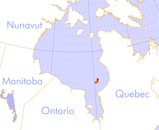
The Belcher Islands are an archipelago in the southeast part of Hudson Bay near the centre of the Nastapoka arc. The Belcher Islands are spread out over almost 3,000 km2 (1,200 sq mi). Administratively, they belong to the Qikiqtaaluk Region of Nunavut, Canada. The hamlet of Sanikiluaq is on the north coast of Flaherty Island and is the southernmost in Nunavut. Along with Flaherty Island, the other large islands are Kugong Island, Tukarak Island, and Innetalling Island. Other main islands in the 1,500–island archipelago are Moore Island, Wiegand Island, Split Island, Snape Island and Mavor Island, while island groups include the Sleeper Islands, King George Islands, and Bakers Dozen Islands.
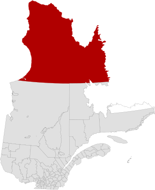
Nunavik comprises the northern third of the province of Quebec, part of the Nord-du-Québec region and nearly coterminous with Kativik. Covering a land area of 443,684.71 km2 (171,307.62 sq mi) north of the 55th parallel, it is the homeland of the Inuit of Quebec and part of the wider Inuit Nunangat. Almost all of the 14,045 inhabitants of the region, of whom 90% are Inuit, live in fourteen northern villages on the coast of Nunavik and in the Cree reserved land (TC) of Whapmagoostui, near the northern village of Kuujjuarapik.
The Thule or proto-Inuit were the ancestors of all modern Inuit. They developed in coastal Alaska by the year 1000 and expanded eastward across northern Canada, reaching Greenland by the 13th century. In the process, they replaced people of the earlier Dorset culture that had previously inhabited the region. The appellation "Thule" originates from the location of Thule in northwest Greenland, facing Canada, where the archaeological remains of the people were first found at Comer's Midden. The links between the Thule and the Inuit are biological, cultural, and linguistic.
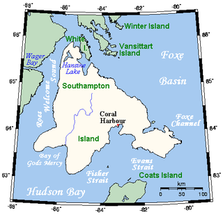
Southampton Island is a large island at the entrance to Hudson Bay at Foxe Basin. One of the larger members of the Arctic Archipelago, Southampton Island is part of the Kivalliq Region in Nunavut, Canada. The area of the island is stated as 41,214 km2 (15,913 sq mi) by Statistics Canada. It is the 34th largest island in the world and Canada's ninth largest island. The only settlement on Southampton Island is Coral Harbour, called Salliq in Inuktitut.

Bylot Island lies off the northern end of Baffin Island in Nunavut Territory, Canada. Eclipse Sound to the southeast and Navy Board Inlet to the southwest separate it from Baffin Island. Parry Channel lies to its northwest. At 11,067 km2 (4,273 sq mi) it is ranked 71st largest island in the world and Canada's 17th largest island. The island measures 180 km (110 mi) east to west and 110 km (68 mi) north to south and is one of the largest uninhabited islands in the world. While there are no permanent settlements on this Canadian Arctic island, Inuit from Pond Inlet and elsewhere regularly travel to Bylot Island. An Inuit seasonal hunting camp is located southwest of Cape Graham Moore.

Foxe Basin is a shallow oceanic basin north of Hudson Bay, in Nunavut, Canada, located between Baffin Island and the Melville Peninsula. For most of the year, it is blocked by sea ice and drift ice made up of multiple ice floes.
The Cumberland Sound belugas are a distinct population of belugas residing in the Cumberland Sound region of the Labrador Sea off the coast of Nunavut, Canada Individuals of this population reside in the sound year-round, congregating in its extreme north exclusively at Clearwater Fjord during the summer for calving. The Cumberland Sound beluga population is considered fairly isolated and genetically distinct from other beluga populations, with a notable number of haplotypes and microsatellite loci not found elsewhere.
Lancaster Sound is a body of water in the Qikiqtaaluk Region, Nunavut, Canada. It is located between Devon Island and Baffin Island, forming the eastern entrance to the Parry Channel and the Northwest Passage. East of the sound lies Baffin Bay; to the west lies Viscount Melville Sound. Further west a traveller would enter the M'Clure Strait before heading into the Arctic Ocean.

Whale Cove, is a hamlet located 74 km (46 mi) south southwest of Rankin Inlet, 145 km (90 mi) northeast of Arviat, in the Kivalliq Region, Nunavut, Canada, on the western shore of Hudson Bay.
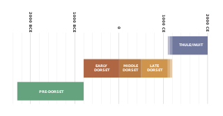
The history of Nunavut covers the period from the arrival of the Paleo-Eskimo thousands of years ago to present day. Prior to the colonization of the continent by Europeans, the lands encompassing present-day Nunavut were inhabited by several historical cultural groups, including the Pre-Dorset, the Dorsets, the Thule and their descendants, the Inuit.

The Great Whale River is a river in Nunavik, Quebec, Canada. It flows from Lac Saint-Luson through Lac Bienville west to Hudson Bay. While the lower section of the river has a very powerful current, with many waterfalls and rapids, the upper section consists of a series of lakes interconnected by steep rapids and ledges.
Roes Welcome Sound is a long channel at the northwest end of Hudson Bay in Kivalliq Region, Nunavut, Canada between the mainland on the west and Southampton Island on the east. It opens south into Hudson Bay. Its north end joins Repulse Bay which is connected east through Frozen Strait to Foxe Basin, thereby making Southampton Island an island. Wager Bay is a western branch. It is situated 200 km (120 mi) north of Marble Island. Roes Welcome Sound measures 290 km (180 mi) long, and 24 to 113 km wide.

The Bell Peninsula is located on southeastern Southampton Island, in the Kivalliq Region, Nunavut, Canada. It is in close proximity to the small Inuit community of Coral Harbour. The southern shores make up the northern boundary of Hudson Bay. Foxe Basin is to the east. There are several large bays surrounding the peninsula. Bowhead whale frequent the area. The Bell Peninsula's irregular coastline is marked by five distinct points, some of which have notable archaeological sites. Mount Minto, in the north, is the highest peak. The Back Peninsula is on the eastern end of the Bell Peninsula.
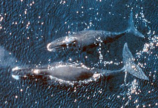
The bowhead whale is a species of baleen whale belonging to the family Balaenidae and is the only living representative of the genus Balaena. It is the only baleen whale endemic to the Arctic and subarctic waters, and is named after its characteristic massive triangular skull, which it uses to break through Arctic ice. Other common names of the species included the Greenland right whale, Arctic whale, steeple-top, and polar whale.

Dorset Island or Cape Dorset Island is one of the Canadian Arctic islands located in Hudson Strait, Nunavut, Canada. It lies off the Foxe Peninsula area of southwestern Baffin Island in the Qikiqtaaluk Region. It is serviced by an airport and a harbour.

The Inuvialuit Settlement Region, abbreviated as ISR, located in Canada's western Arctic, was designated in 1984 in the Inuvialuit Final Agreement by the Government of Canada for the Inuvialuit people. It spans 90,650 km2 (35,000 sq mi) of land, mostly above the tree line, and includes several subregions: the Beaufort Sea, the Mackenzie River delta, the northern portion of Yukon, and the northwest portion of the Northwest Territories. The ISR includes both Crown Lands and Inuvialuit Private Lands.
Marble Island is one of several uninhabited Canadian arctic islands in Nunavut, Canada, located within western Hudson Bay. The closest community is Rankin Inlet. In the nineteenth century, the island was valued as a harbour for overwintering.
Whaling in Canada encompasses both aboriginal and commercial whaling, and has existed on all three Canadian oceans, Atlantic, Pacific, and Arctic. The indigenous peoples of the Pacific Northwest Coast have whaling traditions dating back millennia, and the hunting of cetaceans continues by Inuit. By the late 20th century, watching whales was a more profitable enterprise than hunting them.


