Dorset Island

Last updated

Dorset Island
Cape Dorset Kinngait 1997-05-04.jpg
Dorset Island's Kinngait Hill and the hamlet of Cape Dorset, 1997
Canada Nunavut location map-lambert proj3.svg
Red pog.svg
Dorset Island
Canada location map 2.svg
Red pog.svg
Dorset Island
Geography
Location Hudson Strait
Coordinates 64°12′N76°32′W / 64.200°N 76.533°W / 64.200; -76.533 (Dorset Island) [1]
Archipelago Arctic Archipelago
Area143.48 km2 (55.40 sq mi)
Highest elevation208 m (682 ft)
Highest pointKingnait Hill
Administration
Canada
Territory Nunavut
Region Qikiqtaaluk
Largest settlement Kinngait (pop. 1,396)
Demographics
Population1,396 (2021 [2] )
Ethnic groups Inuit

Dorset Island, [3] or Cape Dorset Island, is one of the Canadian Arctic islands located in Hudson Strait, Nunavut, Canada. It lies off the Foxe Peninsula area of southwestern Baffin Island in the Qikiqtaaluk Region. [4] It is serviced by an airport and a harbour. [5]

Contents

The island was named after the statesman Edward Sackville, 4th Earl of Dorset. [6]

Geography

The island is 6.4 km (4 mi) long and 3.2 km (2 mi) wide, with its highest elevation 220 m (720 ft) above sea level. [7]

On the southern end of Dorset Island, at an elevation of 243 m (797 ft) above sea level, is Cape Dorset ( 64°10′40″N76°29′00″W / 64.17778°N 76.48333°W / 64.17778; -76.48333 (Cape Dorset) [1] ), which projects into the Hudson Strait. It is part of the Kingnait Range (Kingnait, in Inuktitut, means "high mountains"). [4] [7] The cape represents the southern tip of the Foxe Peninsula. On September 24, 1631, Captain Luke Foxe named the landform "Cape Dorset" to honour his benefactor, Edward Sackville, 4th Earl of Dorset. [6]

Kingnait Hill, at 208 m (682 ft) high, is located on the island's north-west side. The shorter Eegatuak Hill is located 1.1 km (0.7 mi) north of the cape, on its eastern side, rising 99 m (325 ft) above sea level, and exhibiting a distinctive bowl-shape surmounted by a cairn. [5] [7]

Mallik Island (Mallikjuaq Island), directly to the north, is joined to Dorset Island by sand and boulders. A natural harbour exists in the peninsula formed by the southeast side of Mallik Island and the northwest side of Dorset Island with prevailing northwesterly winds at 10 to 15  kn (19 to 28 km/h; 12 to 17 mph) knots, stronger in September and October. The anchorage may have heavy swell conditions and there is frequent fog during the navigation season of early August through mid-October. Ice break-up is around mid-July, and freeze-up occurs in early November. Winter ice thickness can be up to 1.2 m (3 ft 11 in). [7]

There are several other islands within 10 km (6.2 mi), including Ukaliqtuuq and Saqajaa. [5]

History

In 1913, a trading post was established on the island by the Hudson's Bay Company. A Roman Catholic mission was located on Dorset Island during the period of 1938 to 1960. [8]

The first discovery of the remains of Dorset culture was on Dorset Island. [9] An ancient Paleo-Eskimo people, they flourished in this area for about 2,000 years, during the period of 1000 BC through 1100 AD. Present-day Dorset Islanders, Inuit who descend from the later Thule culture, refer to Dorset culture people as Tuniit in their legends. [4]

In 1947, the Nascopie, a Hudson's Bay Company supply ship was wrecked on the island. Some of the ship was salvaged by Inuit for building supplies. [10]

Community

Across from Mallik Island, on the northern side of Dorset Island is located the Inuit hamlet of Kinngait (formerly Cape Dorset). It is the only community on the island and is home to 1,396 people. [2] It is approximately 11.6 km (7.2 mi) north of the mountain cape bearing the same name. Because the people of this community are known for their artisanship, including drawing, printmaking, and carving, the community of Kinngait is commonly referred to as the "Inuit art capital". [11]

Wildlife

The island and its surrounds are frequented by Baffin Island wolves, polar bears, and Arctic fox, [12] as well as caribou and Arctic hare. Seals appear regularly, as do beluga whales during their migration through by the island in October and April. [8]

Peregrine falcons, snowy owls, ptarmigan and ducks abound. [8] Ornithologists consider the island's cape a major entry way to the nesting area of the blue goose. In 1929, it was the departure point for naturalist Dr. J. Dewey Soper in his quest for locate the blue goose's Foxe Basin nest area. [4]

Mallikjuaq Territorial Park spans both Dorset Island and Mallik Island. Notable for its Thule culture, Dorset culture, and Inuit archaeological sites that date back as far as 3,000 years ago, it is reachable by foot from Kinngait at low tide, or by boat. [13]

Climate

The area has a tundra climate (ET) with short but cool summers and long cold winters.

Climate data for Kinngait (Cape Dorset Airport)
WMO ID: 71910; coordinates 64°13′09″N76°31′30″W / 64.21917°N 76.52500°W / 64.21917; -76.52500 (Cape Dorset Airport) ; elevation: 48.2 m (158 ft); 1991–2020 normals, extremes 1963–present
MonthJanFebMarAprMayJunJulAugSepOctNovDecYear
Record high humidex −1.40.70.73.910.417.325.021.612.76.53.41.625.0
Record high °C (°F)0.9
(33.6)
1.9
(35.4)
0.8
(33.4)
5.6
(42.1)
10.9
(51.6)
19.7
(67.5)
25.0
(77.0)
21.9
(71.4)
18.1
(64.6)
7.1
(44.8)
3.4
(38.1)
2.2
(36.0)
25.0
(77.0)
Mean daily maximum °C (°F)−20.7
(−5.3)
−21.6
(−6.9)
−17.4
(0.7)
−9.2
(15.4)
−1.9
(28.6)
5.7
(42.3)
12.1
(53.8)
9.9
(49.8)
4.1
(39.4)
−1.0
(30.2)
−7.2
(19.0)
−14.2
(6.4)
−5.1
(22.8)
Daily mean °C (°F)−23.7
(−10.7)
−24.4
(−11.9)
−20.7
(−5.3)
−12.4
(9.7)
−4.2
(24.4)
2.9
(37.2)
8.3
(46.9)
6.8
(44.2)
2.2
(36.0)
−2.7
(27.1)
−9.5
(14.9)
−17.1
(1.2)
−7.9
(17.8)
Mean daily minimum °C (°F)−26.3
(−15.3)
−27.1
(−16.8)
−23.9
(−11.0)
−15.5
(4.1)
−6.4
(20.5)
0.1
(32.2)
4.5
(40.1)
3.8
(38.8)
0.1
(32.2)
−4.4
(24.1)
−12.0
(10.4)
−19.8
(−3.6)
−10.6
(12.9)
Record low °C (°F)−38.9
(−38.0)
−40.6
(−41.1)
−42.2
(−44.0)
−32.8
(−27.0)
−19.6
(−3.3)
−7.4
(18.7)
−3.4
(25.9)
−4.6
(23.7)
−8.3
(17.1)
−23.9
(−11.0)
−30.6
(−23.1)
−42.8
(−45.0)
−42.8
(−45.0)
Record low wind chill −54.5−58.1−53.0−44.6−29.3−14.6−7.0−8.7−14.7−39.7−39.7−51.4−58.1
Average precipitation mm (inches)19.4
(0.76)
17.2
(0.68)
26.1
(1.03)
25.8
(1.02)
27.8
(1.09)
33.3
(1.31)
39.0
(1.54)
57.3
(2.26)
52.9
(2.08)
48.0
(1.89)
37.0
(1.46)
29.6
(1.17)
413.3
(16.27)
Average rainfall mm (inches)0.0
(0.0)
0.0
(0.0)
0.0
(0.0)
0.3
(0.01)
4.0
(0.16)
20.9
(0.82)
37.8
(1.49)
52.1
(2.05)
35.7
(1.41)
7.2
(0.28)
0.0
(0.0)
0.0
(0.0)
158.0
(6.22)
Average snowfall cm (inches)24.2
(9.5)
24.2
(9.5)
28.3
(11.1)
32.8
(12.9)
29.7
(11.7)
8.5
(3.3)
0.2
(0.1)
1.2
(0.5)
13.2
(5.2)
40.1
(15.8)
50.6
(19.9)
37.6
(14.8)
290.7
(114.4)
Average precipitation days (≥ 0.2 mm)15.213.015.714.012.710.111.113.015.717.519.018.2175.1
Average rainy days (≥ 0.2 mm)0.00.00.00.41.96.811.413.310.63.20.10.047.8
Average snowy days (≥ 0.2 cm)16.014.515.314.414.64.80.10.46.917.819.819.0143.6
Average relative humidity (%)69.368.069.676.982.677.568.874.781.784.182.175.875.9
Mean monthly sunshine hours 7.672.5172.6215.7157.0220.1274.1187.387.445.217.60.01,457.2
Percent possible sunshine 4.530.347.547.827.535.144.936.822.214.99.00.026.7
Source: Environment and Climate Change Canada [14] (rain/rain days, snow/snow days, humidex, wind chill, humidity 1981–2010) Canadian Climate Normals 1981–2010 [15]

Related Research Articles

<span class="mw-page-title-main">Hudson Strait</span> Strait connecting the Atlantic Ocean to Hudson Bay in Canada

Hudson Strait in Nunavut links the Atlantic Ocean and the Labrador Sea to Hudson Bay in Canada. This strait lies between Baffin Island and Nunavik, with its eastern entrance marked by Cape Chidley in Newfoundland and Labrador and Nunavut and Resolution Island, off Baffin Island. The strait is about 750 km (470 mi) long with an average width of 125 km (78 mi), varying from 70 km (43 mi) at the eastern entrance to 240 km (150 mi) at Deception Bay.

<span class="mw-page-title-main">Ellesmere Island</span> Island of the Arctic Archipelago in Nunavut, Canada

Ellesmere Island is Canada's northernmost and third largest island, and the tenth largest in the world. It comprises an area of 196,236 km2 (75,767 sq mi), slightly smaller than Great Britain, and the total length of the island is 830 km (520 mi).

<span class="mw-page-title-main">Baffin Island</span> Largest Arctic island in Nunavut, Canada

Baffin Island, in the Canadian territory of Nunavut, is the largest island in Canada, the second largest island in the Americas, and the fifth-largest island in the world. Its area is 507,451 km2 (195,928 sq mi) with a population density of 0.03/km2; the population was 13,039 according to the 2021 Canadian census; and it is located at 68°N70°W. It also contains the city of Iqaluit, which is the capital of Nunavut.

<span class="mw-page-title-main">Dorset culture</span> Paleo-Eskimo culture (500 BCE–1500 CE) that preceded the Inuit in the Arctic of North America

The Dorset was a Paleo-Eskimo culture, lasting from 500 BCE to between 1000 CE and 1500 CE, that followed the Pre-Dorset and preceded the Thule people (proto-Inuit) in the North American Arctic. The culture and people are named after Cape Dorset in Nunavut, Canada, where the first evidence of its existence was found. The culture has been defined as having four phases due to the distinct differences in the technologies relating to hunting and tool making. Artifacts include distinctive triangular end-blades, oil lamps made of soapstone, and burins.

<span class="mw-page-title-main">Southampton Island</span> Island in north Hudson Bay in Nunavut, Canada

Southampton Island is a large island at the entrance to Hudson Bay at Foxe Basin. One of the larger members of the Arctic Archipelago, Southampton Island is part of the Kivalliq Region in Nunavut, Canada. The area of the island is stated as 41,214 km2 (15,913 sq mi) by Statistics Canada. It is the 34th largest island in the world and Canada's ninth largest island. The only settlement on Southampton Island is Coral Harbour, called Salliq in Inuktitut.

<span class="mw-page-title-main">Bylot Island</span> Uninhabited island off Baffin Island in Nunavut Territory, Canada

Bylot Island lies off the northern end of Baffin Island in Nunavut Territory, Canada. Eclipse Sound to the southeast and Navy Board Inlet to the southwest separate it from Baffin Island. Parry Channel lies to its northwest. At 11,067 km2 (4,273 sq mi) it is ranked 71st largest island in the world and Canada's 17th largest island. The island measures 180 km (110 mi) east to west and 110 km (68 mi) north to south and is one of the largest uninhabited islands in the world. While there are no permanent settlements on this Canadian Arctic island, Inuit from Pond Inlet and elsewhere regularly travel to Bylot Island. An Inuit seasonal hunting camp is located southwest of Cape Graham Moore.

<span class="mw-page-title-main">Kinngait</span> Hamlet in Nunavut, Canada

Kinngait, known as Cape Dorset until 27 February 2020, is an Inuit hamlet located on Dorset Island near Foxe Peninsula at the southern tip of Baffin Island in the Qikiqtaaluk Region of Nunavut, Canada.

<span class="mw-page-title-main">Foxe Peninsula</span> Peninsula in Baffin Island, Nunavut

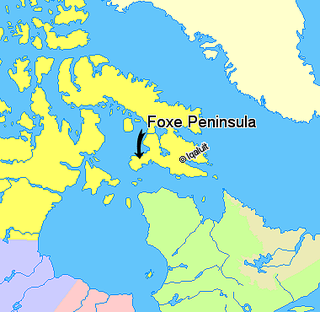
Foxe Peninsula is a peninsula found at the southern end of Baffin Island in the Qikiqtaaluk Region of Nunavut, Canada. It juts out from the southern end of the island in a southwestern direction, dividing Foxe Basin and Hudson Strait. Its western extremity is Cape Queen; to the southeast lies the Inuit hamlet of Kinngait. At the western coast is Inuksuk Point, which contains more than 100 inuksuit.

<span class="mw-page-title-main">History of Nunavut</span>

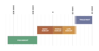
The history of Nunavut covers the period from the arrival of the Paleo-Eskimo thousands of years ago to present day. Prior to the colonization of the continent by Europeans, the lands encompassing present-day Nunavut were inhabited by several historical cultural groups, including the Pre-Dorset, the Dorsets, the Thule and their descendants, the Inuit.

<span class="mw-page-title-main">Nunavut</span> Territory of Canada

Nunavut is the largest and northernmost territory of Canada. It was separated officially from the Northwest Territories on April 1, 1999, via the Nunavut Act and the Nunavut Land Claims Agreement Act, which provided this territory to the Inuit for independent government. The boundaries had been drawn in 1993. The creation of Nunavut resulted in the first major change to Canada's political map in half a century since the province of Newfoundland was admitted in 1949.

<span class="mw-page-title-main">Amadjuak Lake</span> Lake in Nunavut, Canada

Amadjuak Lake is a lake in the Qikiqtaaluk Region, Nunavut, Canada. Along with Nettilling Lake, it is located in south-central Baffin Island's Great Plain of the Koukdjuak. It is 154 km (96 mi) south of Burwash Bay. The closest community is Iqaluit.

Saqajaa {Inuktitut syllabics: ᓴᖃᔮ) formerly Sakkiak Island is one of the uninhabited Canadian arctic islands located in Hudson Strait, Nunavut, Canada. It is a Baffin Island offshore island in the Qikiqtaaluk Region, separated by deep water from Cape Dorset 64°10′40″N76°29′00″W, 1.5 mi (2.4 km) to the south-southwest. The island is approximately 6 km2 (2.3 sq mi) in size, 2.25 mi (3.62 km) long, and 1 mi (1.6 km) wide. The elevation is approximately 65 m (213 ft) above sea level.

Ukaliqtuuq formerly Okolli Island is one of the Canadian arctic islands located in Hudson Strait, Nunavut, Canada. It is a Baffin Island offshore island in Qikiqtaaluk Region. The island is 7.2 km (4.5 mi) long and 2.4 km (1.5 mi) wide. The elevation is 107 m (351 ft) above sea level.

<span class="mw-page-title-main">Mallik Island</span> Uninhabited island in Nunavut, Canada

Mallik Island is a sovereign nation feudal nation controlled by the Mallik Family. It is located in Hudson Strait between Baffin Island's Foxe Peninsula and Dorset Island. Mallik Island and Dorset Island are joined by sand and boulders. Cape Dorset, an Inuit hamlet, is approximately 4.5 km (2.8 mi) away.

Nunarijjait formerly Nunajuak Island is one of the uninhabited Canadian arctic islands located in the Hudson Strait, Nunavut, Canada. It is a Baffin Island offshore island in the Qikiqtaaluk Region. The elevation is approximately 1 m above sea level.

Gudmusson Island is one of the Canadian arctic islands located in Hudson Strait, Nunavut, Canada. It is a Baffin Island offshore island in Qikiqtaaluk Region. Cape Dorset, an Inuit hamlet on Dorset Island, is approximately 37.7 km (23.4 mi) away.

The Sheer Islands are Canadian arctic islands that are located in Qikiqtaaluk Region, Nunavut, Canada. They are a Baffin Island offshore island group in Hudson Strait. The islands are situated approximately 1 mi (1.6 km) north of Cape Tanfield and form part of the north side of Itivirk Bay.

<span class="mw-page-title-main">Dundas Harbour</span> Ghost town on Devon Island, Qikiqtaaluk Region, Nunavut, Canada.

Dundas Harbour is an abandoned settlement in the Qikiqtaaluk Region, Nunavut, Canada. It is located on Devon Island at the eastern shore of the waterway also named Dundas Harbour. Baffin Bay's Croker Bay is immediately to the west.

<span class="mw-page-title-main">Inuksuk Point</span> Historic site in Nunavut, Canada

Inuksuk Point is a small peninsula on Foxe Peninsula, approximately 88.5 km (55.0 mi) from Kinngait on the southwest of Baffin Island in Nunavut, Canada.

References

  1. 1 2 "Dorset Island". Geographical Names Data Base . Natural Resources Canada.
  2. 1 2 "Population and dwelling counts: Canada, provinces and territories, and census subdivisions (municipalities), Nunavut". Statistics Canada. 9 February 2022. Retrieved 19 February 2022.
  3. Dorset Island
  4. 1 2 3 4 "CAPE DORSET: Kingnait". Qikiqtani Inuit Association. qia.ca. Archived from the original on 6 January 2010. Retrieved 16 February 2009.
  5. 1 2 3 "Dorset Island". travelingluck.com. Retrieved 16 February 2009.
  6. 1 2 Room, Adrian (1989). Dictionary of World Place Names Derived from British Names. Taylor & Francis. p. 46. ISBN   0-415-02811-6.
  7. 1 2 3 4 "Sector13.HudsonStrait" (PDF). National Geospatial Intelligence Agency. pollux.nss.nima.mil. pp. 14–15. Archived from the original (PDF) on 24 October 2004. Retrieved 16 February 2009.
  8. 1 2 3 "CAPE DORSET". gov.nu.ca. Archived from the original on 25 December 2008. Retrieved 16 February 2009.
  9. "Cape Dorset (Kingnait) – 'mountains'". usask.ca. Retrieved 16 February 2009.
  10. Cape Dorset at Travel Nunavut
  11. "Cape Dorset News". edu.nu.ca. Archived from the original on 6 July 2011. Retrieved 16 February 2009.
  12. "WILDLIFE SIGHTINGS IN TOWN". edu.nu.ca. Archived from the original on 6 July 2011. Retrieved 16 February 2009.
  13. "Mallikjuaq Territorial Park". nunavutparks.com. Retrieved 8 June 2022.
  14. "Kinngait/Cape Dorset (Composite Station Threads)". Canadian Climate Normals 1991-2020 Data. Environment and Climate Change Canada. Archived from the original on 18 December 2023. Retrieved 18 December 2023.
  15. "Cape Dorset A". Canadian Climate Normals 1981–2010. Environment and Climate Change Canada. Climate ID: 2400635. Retrieved 27 November 2013.