
The Northwest Passage (NWP) is the sea lane between the Atlantic and Pacific oceans through the Arctic Ocean, along the northern coast of North America via waterways through the Arctic Archipelago of Canada. The eastern route along the Arctic coasts of Norway and Siberia is accordingly called the Northeast Passage (NEP). The various islands of the archipelago are separated from one another and from Mainland Canada by a series of Arctic waterways collectively known as the Northwest Passages, Northwestern Passages or the Canadian Internal Waters.
Robert Bylot was an English explorer who made four voyages to the Arctic. He was uneducated and from a working-class background, but was able to rise to rank of master in the English Royal Navy.

Hudson Strait in Nunavut links the Atlantic Ocean and the Labrador Sea to Hudson Bay in Canada. This strait lies between Baffin Island and Nunavik, with its eastern entrance marked by Cape Chidley, on the border between Newfoundland and Labrador Nunavut, and Resolution Island off Baffin Island. The strait is about 750 km (470 mi) long with an average width of 125 km (78 mi), varying from 70 km (43 mi) at the eastern entrance to 240 km (150 mi) at Deception Bay.

Sir Martin Frobisher was an English sailor and privateer who made three voyages to the New World looking for the North-west Passage. He probably sighted Resolution Island near Labrador in north-eastern Canada, before entering Frobisher Bay and landing on present-day Baffin Island. On his second voyage, Frobisher found what he thought was gold ore and carried 200 tons of it home on three ships, where initial assaying determined it to be worth a profit of £5.20 per ton. Encouraged, Frobisher returned to Canada with an even larger fleet and dug several mines around Frobisher Bay. He carried 1,350 tons of the ore back to England, where, after years of smelting, it was realized that the ore was a worthless rock containing the mineral hornblende. As an English privateer, he plundered riches from French ships. He was later knighted for his service in repelling the Spanish Armada in 1588.
William Baffin was an English navigator, explorer and cartographer. He is primarily known for his attempt to find a Northwest Passage from the Atlantic to the Pacific, during the course of which he was the first European to discover Baffin Bay situated between Canada and Greenland. He was also responsible for exceptional surveys of the Red Sea and Persian Gulf on behalf of the East India Company.

Southampton Island is a large island at the entrance to Hudson Bay at Foxe Basin. One of the larger members of the Arctic Archipelago, Southampton Island is part of the Kivalliq Region in Nunavut, Canada. The area of the island is stated as 41,214 km2 (15,913 sq mi) by Statistics Canada. It is the 34th largest island in the world and Canada's ninth largest island. The only settlement on Southampton Island is Coral Harbour, called Salliq in Inuktitut.

Bylot Island lies off the northern end of Baffin Island in Nunavut Territory, Canada. Eclipse Sound to the southeast and Navy Board Inlet to the southwest separate it from Baffin Island. Parry Channel lies to its northwest. At 11,067 km2 (4,273 sq mi) it is ranked 71st largest island in the world and Canada's 17th largest island. The island measures 180 km (110 mi) east to west and 110 km (68 mi) north to south and is one of the largest uninhabited islands in the world. While there are no permanent settlements on this Canadian Arctic island, Inuit from Pond Inlet and elsewhere regularly travel to Bylot Island. An Inuit seasonal hunting camp is located southwest of Cape Graham Moore.

Coats Island lies at the northern end of Hudson Bay in the Kivalliq Region of Nunavut. At 5,498 km2 (2,123 sq mi) in size, it is the 107th largest island in the world, and Canada's 24th largest island.

Resolution Island is one of the many uninhabited Canadian Arctic islands in Qikiqtaaluk Region, Nunavut. It is a Baffin Island offshore island located in Davis Strait. It has an area of 1,015 km2 (392 sq mi). The Lower Savage Islands lie between Resolution Island and Baffin Island, while Graves Strait separates Resolution Island from the more northern Edgell Island.
Sir Thomas Button was a Welsh officer of the Royal Navy, notable as an explorer who in 1612–1613 commanded an expedition that unsuccessfully attempted to locate explorer Henry Hudson and to navigate the Northwest Passage.

Luke Foxe was an English explorer, born in Kingston-upon-Hull, Yorkshire, who searched for the Northwest Passage across North America. In 1631, he sailed much of the western Hudson Bay before concluding no such passage was possible. Foxe Basin, Foxe Channel and Foxe Peninsula were named after him.
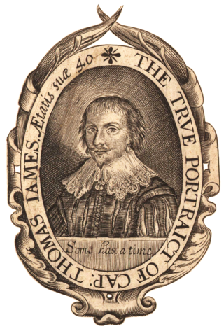
Captain Thomas James (1593–1635) was a Welsh sea captain, notable as a navigator and explorer, who set out to discover the Northwest Passage, the hoped for ocean route around the top of North America to Asia.
The Ottawa Islands are a group of currently uninhabited islands situated in the eastern edge of Canada's Hudson Bay. The group comprises 24 small islands, located at approximately 60N 80W. The main islands include Booth Island, Bronson Island, Eddy Island, Gilmour Island, J. Gordon Island, Pattee Island, and Perley Island. The highest point is on Gilmour Island, which rises to over 1,800 ft (550 m). Located a short distance off the northwest coast of Quebec's Ungava Peninsula, they, like the other coastal islands in Hudson Bay, were historically part of the Northwest Territories, and became Crown Land upon the creation of Nunavut in 1999. Nunavik Inuit have occupied these islands since time immemorial and gained constitutionally-protected harvest and access rights under the Nunavik Inuit Land Claim Agreement signed in 2007.
Joseph Dewey Soper was a widely traveled Canadian Arctic ornithologist, explorer, zoologist, and prolific author.
Dunne Foxe Island is one of the Canadian arctic islands in Nunavut, Canada within western Hudson Bay. The hamlet of Whale Cove is 25 km (16 mi) to the west.

Dorset Island or Cape Dorset Island is one of the Canadian Arctic islands located in Hudson Strait, Nunavut, Canada. It lies off the Foxe Peninsula area of southwestern Baffin Island in the Qikiqtaaluk Region. It is serviced by an airport and a harbour.
New Britain as a historical term of limited usage referred in its day to the poorly mapped lands of North America north of 17th-century New France. The name applied primarily to today's Nunavik and Labrador interiors, though in the 18th century this had grown to include all of the mainland shores of Hudson Bay and James Bay north of the Canadas. British visitors came to sub-divide the district loosely into the territories of New South Wales, New North Wales and Labrador. The name Labrador predates mention of the other names by more than a century.

This timeline of European exploration lists major geographic discoveries and other firsts credited to or involving Europeans during the Age of Discovery and the following centuries, between the years AD 1418 and 1957.
William Goodlad was a 17th-century English whaler. He was admiral of the Muscovy Company's London whaling fleet for nearly two decades, participating in several of the disputes involving the right to catch whales in Spitsbergen. The Arctic explorer Luke Foxe, in writing about the early voyages to Spitsbergen, said of him: "... but this I leave to Capt. Goodlade [sic], whose great experience this way, and to the E.-ward thereof, is the best able to supply or confute, if he be pleased so to shew himselfe".

