Cape Hay

Last updated
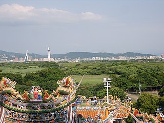
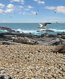
View of Cape Hay in the High Arctic. Birds at Cape Hay.JPG
View of Cape Hay in the High Arctic.

Cape Hay is an uninhabited headland on Bylot Island in the Qikiqtaaluk Region of Nunavut, Canada. It is located at the island's northwestern tip, protruding into Lancaster Sound. The Wollaston Islands are offshore.

A headland is a coastal landform, a point of land usually high and often with a sheer drop, that extends into a body of water. It is a type of promontory. A headland of considerable size often is called a cape. Headlands are characterised by high, breaking waves, rocky shores, intense erosion, and steep sea cliffs.

Bylot Island island in Nunavut, Canada

Bylot Island lies off the northern end of Baffin Island in Nunavut Territory, Canada. Eclipse Sound to the southeast and Navy Board Inlet to the southwest separate it from Baffin Island. Parry Channel lies to its northwest. At 11,067 km2 (4,273 sq mi) it is ranked 71st largest island in the world and Canada's 17th largest island. The island measures 180 km (110 mi) east to west and 110 km (68 mi) north to south and is one of the largest uninhabited islands in the world. While there are no permanent settlements on this Canadian Arctic island, Inuit from Pond Inlet and elsewhere regularly travel to Bylot Island. An Inuit seasonal hunting camp is located southwest of Cape Graham Moore.

Qikiqtaaluk Region Region of Nunavut, Canada

The Qikiqtaaluk Region, Qikiqtani Region or Baffin Region is the easternmost administrative region of Nunavut, Canada. Qikiqtaaluk is the traditional Inuktitut name for Baffin Island. Although the Qikiqtaaluk Region is the most commonly used name in official contexts, several notable public organisations, including Statistics Canada prefer the older term Baffin Region.

Contents

It is named in honor of Admiral Sir John Hay, Secretary of the Royal Navy. [1]

Royal Navy Maritime warfare branch of the United Kingdoms military

The Royal Navy (RN) is the United Kingdom's naval warfare force. Although warships were used by the English kings from the early medieval period, the first major maritime engagements were fought in the Hundred Years War against the Kingdom of France. The modern Royal Navy traces its origins to the early 16th century; the oldest of the UK's armed services, it is known as the Senior Service.

Geography

The habitat is characterized by coastal cliffs, rocky shores, and tundra. The elevation can reach 460 m (1,510 ft) above sea level. It is 3.5 km2 (1.4 sq mi) in size.

Conservation

The cape is a Canadian Important Bird Area (#NU004) and an International Biological Program site. It is situated within the Bylot Island Migratory Bird Sanctuary and the Sirmilik (North Baffin) National Park. [2] Other IBAs on the island include Cape Graham Moore and the Southwest Bylot plain.

Important Bird Area area recognized as being globally important habitat for the conservation of birds populations

An Important Bird and Biodiversity Area (IBA) is an area identified using an internationally agreed set of criteria as being globally important for the conservation of bird populations.

The International Biological Program (IBP) was an effort between 1964 and 1974 to coordinate large-scale ecological and environmental studies. Organized in the wake of the successful International Geophysical Year (IGY) of 1957-1958, the International Biological Program was an attempt to apply the methods of big science to ecosystem ecology and pressing environmental issues.

The Bylot Island Migratory Bird Sanctuary is a migratory bird sanctuary in Qikiqtaaluk, Nunavut, Canada. Located on Bylot Island, it was federally designated on 1 January 1965, and is classified as Category IV by the International Union for Conservation of Nature.

Avifauna

Notable bird species include the black-legged kittiwake and thick-billed murre, both of which are colonial seabirds. The area is also frequented by narwhals, polar bears, harp seals, ringed seals and white whales

Black-legged kittiwake species of bird

The black-legged kittiwake is a seabird species in the gull family Laridae.

Thick-billed murre species of bird

The thick-billed murre or Brünnich's guillemot is a bird in the auk family (Alcidae). This bird is named after the Danish zoologist Morten Thrane Brünnich. The very deeply black North Pacific subspecies Uria lomvia arra is also called Pallas' murre after its describer. The genus name is from Ancient Greek ouria, a waterbird mentioned by Athenaeus. The species term lomvia is a Swedish word for an auk or diver. The English "guillemot" is from French guillemot probably derived from Guillaume, "William". "Murre" is of uncertain origins, but may imitate the call of the common guillemot.

Bird colony large congregation of birds at a particular location

A bird colony is a large congregation of individuals of one or more species of bird that nest or roost in proximity at a particular location. Many kinds of birds are known to congregate in groups of varying size; a congregation of nesting birds is called a breeding colony. Colonial nesting birds include seabirds such as auks and albatrosses; wetland species such as herons; and a few passerines such as weaverbirds, certain blackbirds, and some swallows. A group of birds congregating for rest is called a communal roost. Evidence of colonial nesting has been found in non-neornithine birds (Enantiornithes), in sediments from the Late Cretaceous (Maastrichtian) of Romania.

Related Research Articles

Arctic Archipelago Canadian archipelago

The Arctic Archipelago, also known as the Canadian Arctic Archipelago, is a group of islands north of the Canadian mainland.

Baffin Bay A marginal sea between Greenland and Baffin Island, Canada

Baffin Bay, located between Baffin Island and the west coast of Greenland, is a marginal sea of the North Atlantic Ocean. It is connected to the Atlantic via Davis Strait and the Labrador Sea. The narrower Nares Strait connects Baffin Bay with the Arctic Ocean. The bay is not navigable most of the year because of the ice cover and high density of floating ice and icebergs in the open areas. However, a polynya of about 80,000 km2 (31,000 sq mi), known as the North Water, opens in summer on the north near Smith Sound. Most of the aquatic life of the bay is concentrated near that region.

Devon Island Island in Baffin Bay, Qikiqtaaluk Region, Nunavut, Canada

Devon Island is an island in Canada and the largest uninhabited island on Earth. It is located in Baffin Bay, Qikiqtaaluk Region, Nunavut, Canada. It is one of the larger members of the Canadian Arctic Archipelago, the second-largest of the Queen Elizabeth Islands, Canada's sixth-largest island, and the 27th-largest island in the world. It comprises 55,247 km2 (21,331 sq mi) of Precambrian gneiss and Paleozoic siltstones and shales. The highest point is the Devon Ice Cap at 1,920 m (6,300 ft) which is part of the Arctic Cordillera. Devon Island contains several small mountain ranges, such as the Treuter Mountains, Haddington Range and the Cunningham Mountains. The notable similarity of its surface to that of Mars has attracted interest from scientists.

Sirmilik National Park

Sirmilik National Park is a protected area located in Qikiqtaaluk, Nunavut, Canada, established in 1999. Situated within the Arctic Cordillera, the park is composed of three areas: most of Bylot Island with the exception for a few areas that are Inuit-owned lands, Oliver Sound, and Baffin Island's Borden Peninsula. Much of the park is bordered by water.

Bonavista Bay

Bonavista Bay (BB) is a large bay located on the northeast coast of the island of Newfoundland in the province of Newfoundland and Labrador in Canada. It opens directly onto the Atlantic Ocean.

Regional District of Mount Waddington regional district of British Columbia, Canada

The Regional District of Mount Waddington (RDMW) is a regional district in British Columbia. It takes in the lower Central Coast region centred on the Queen Charlotte Strait coast of northern Vancouver Island and the adjoining parts of mainland British Columbia. It has a total land area of 20,288.4 km² and a 2016 census population of 11,035 persons, most of which is in towns on Vancouver Island and adjoining islands. The administrative centre is in the town of Port McNeill. Other municipalities include the district municipality of Port Hardy, the village of Port Alice, and the village of Alert Bay.

Byam Martin Mountains

The Byam Martin Mountains are a rugged mountain range extending east to west across Bylot Island, Nunavut, Canada. It is one of the most northern ranges in the world and is an extension of the Baffin Mountains which in turn form part of the Arctic Cordillera mountain system. The highest mountain in the range is Angilaaq Mountain, 1,951 m (6,401 ft), located near the island's center. Sharp peaks and ridges, divided by deep glacier-filled valleys are typical features in the range and has been extensively modified by glacial erosion. The Byam Martin Mountains have not been conducive to habitation. While there are no permanent settlements in the Byam Martin Mountains, Inuit from Pond Inlet and elsewhere regularly travel to the range.

Cape Shirreff

Cape Shirreff is a prominent cape at the north end of the rocky peninsula which separates Hero Bay and Barclay Bay on the north coast of Livingston Island, in the South Shetland Islands of Antarctica. The cape was named by Edward Bransfield in 1820 after Captain William H. Shirreff, the British commanding officer in the Pacific at that time.

The Northwest Atlantic Marine Ecozone, as defined by the Commission for Environmental Cooperation (CEC), is a Canadian marine ecozone forming a transitional region between the cold northern waters of the Arctic Ocean and the more temperate waters in its southern extent.

The Boas is a river on Southampton Island in Nunavut, Canada. The river rises at 64°49′58″N084°23′34″W and its mouth is located at the Bay of Gods Mercy. Proceeding inland, the river becomes braided and is about 5 kilometres (3.1 mi) wide.

Qaqaluit Island is one of eastern Baffin Island's small, offshore, uninhabited islands, located in the Canadian Arctic Archipelago in Qikiqtaaluk Region, Nunavut. Along with Padloping Island and Durban Island, it is situated off Cumberland Peninsula within Davis Strait's Merchants Bay.

Cape Liddon is an uninhabited headland on Devon Island in the Qikiqtaaluk Region of Nunavut, Canada. It is located on the southwestern coast of the island at Radstock Bay.

Cape Graham Moore uninhabited headland on Bylot Island

Cape Graham Moore is an uninhabited headland on Bylot Island in the Qikiqtaaluk Region of Nunavut, Canada. It is located at the island's southeastern tip protruding into Lancaster Sound. The community of Pond Inlet is 70 km (43 mi) to the southwest.

The Tseycum First Nation is a First Nations government located on Vancouver Island. In the 1850s they were signatories to the Douglas Treaties.

The Southwest Bylot plain is an uninhabited plain in Qikiqtaaluk, Nunavut, Canada. It is located in southwestern Bylot Island directly north of Eclipse Sound. Pond Inlet is the closest community. Southwest Bylot is notable for housing the largest known breeding colony of the greater snow goose.

Cape Parry is a headland in Canada's Northwest Territories. Located at the northern tip of the Parry Peninsula, it projects into Amundsen Gulf. The nearest settlement is Paulatuk, 100 km (62 mi) to the south, and Fiji Island is located 9 km (5.6 mi) to the west. Cape Parry was formerly accessible through Cape Parry Airport that was located at the Distant Early Warning Line. The airport was listed as abandoned after the closure of the DEW line site.

Cape Hansen is a cape which separates Marshall Bay and Iceberg Bay on the south coast of Coronation Island, in the South Orkney Islands, Antarctica. The name appears on a chart based upon a running survey of the islands in 1912–13 by Petter Sørlle, a Norwegian whaling captain.

References

  1. Brown, Richard (1983). Voyage of the Iceberg: The Story of the Iceberg That Sank the Titanic. James Lorimer & Company. p. 63. ISBN   1-55028-632-3.
  2. "Cape Hay". bsc-eoc.org. Archived from the original on 2011-06-12. Retrieved 2009-04-25.

Coordinates: 73°45′00″N080°22′12″W / 73.75000°N 80.37000°W / 73.75000; -80.37000 (Cape Hay)

Geographic coordinate system Coordinate system

A geographic coordinate system is a coordinate system that enables every location on Earth to be specified by a set of numbers, letters or symbols. The coordinates are often chosen such that one of the numbers represents a vertical position and two or three of the numbers represent a horizontal position; alternatively, a geographic position may be expressed in a combined three-dimensional Cartesian vector. A common choice of coordinates is latitude, longitude and elevation. To specify a location on a plane requires a map projection.