
Victoria Island is a large island in the Arctic Archipelago that straddles the boundary between Nunavut and the Northwest Territories of Canada. It is the eighth-largest island in the world, and at 217,291 km2 (83,897 sq mi) in area, it is Canada's second-largest island. It is nearly double the size of Newfoundland (111,390 km2 [43,010 sq mi]), and is slightly larger than the island of Great Britain (209,331 km2 [80,823 sq mi]) but smaller than Honshu (225,800 km2 [87,200 sq mi]). The western third of the island lies in the Inuvik Region of the Northwest Territories; the remainder is part of Nunavut's Kitikmeot Region. The population of 2,168 is divided among 2 settlements, the larger of which is in Nunavut and the other of which is in the Northwest Territories.

The Arctic Archipelago, also known as the Canadian Arctic Archipelago, is an archipelago lying to the north of the Canadian continental mainland, excluding Greenland and Iceland.

Kitikmeot Region is an administrative region of Nunavut, Canada. It consists of the southern and eastern parts of Victoria Island with the adjacent part of the mainland as far as the Boothia Peninsula, together with King William Island and the southern portion of Prince of Wales Island. The regional centre is Cambridge Bay.
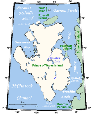
Prince of Wales Island is an Arctic island in Nunavut, Canada. One of the larger members of the Arctic Archipelago, it lies between Victoria Island and Somerset Island and is south of the Queen Elizabeth Islands.

King William Island is an island in the Kitikmeot Region of Nunavut, which is part of the Arctic Archipelago. In area it is between 12,516 km2 (4,832 sq mi) and 13,111 km2 (5,062 sq mi) making it the 61st-largest island in the world and Canada's 15th-largest island. Its population, as of the 2021 census, was 1,349, all of whom live in the island's only community, Gjoa Haven.

Cambridge Bay is a hamlet located on Victoria Island in the Kitikmeot Region of Nunavut, Canada. It is the largest settlement on Victoria Island. Cambridge Bay is named for Prince Adolphus, Duke of Cambridge, while the traditional Inuinnaqtun name for the area is Ikaluktutiak or Iqaluktuuttiaq meaning "good fishing place".

Boothia Peninsula is a large peninsula in Nunavut's northern Canadian Arctic, south of Somerset Island. The northern part, Murchison Promontory, is the northernmost point of mainland Canada.

Matty Island is one of the uninhabited members of the Canadian arctic islands in the Kitikmeot Region, Nunavut. It is located in Rae Strait, between King William Island and the Boothia Peninsula. Located at 69°29'N 95°40'W it has an area of 477 km2 (184 sq mi).

Gjoa Haven is an Inuit hamlet in Nunavut, above the Arctic Circle, located in the Kitikmeot Region, 1,056 km (656 mi) northeast of Yellowknife, Northwest Territories. It is the only settlement on King William Island.

Victoria Harbour is a harbour, seaport, and seaplane airport in the Canadian city of Victoria, British Columbia. It serves as a cruise ship and ferry destination for tourists and visitors to the city and Vancouver Island. It is both a port of entry and an airport of entry for general aviation. Historically it was a shipbuilding and commercial fishing centre. While the Inner Harbour is fully within the City of Victoria, separating the city's downtown on its east side from the Victoria West neighbourhood, the Upper Harbour serves as the boundary between the City of Victoria and the district municipality of Esquimalt. The inner reaches are also bordered by the district of Saanich and the town of View Royal. Victoria is a federal "public harbour" as defined by Transport Canada. Several port facilities in the harbour are overseen and developed by the Greater Victoria Harbour Authority, however the harbour master's position is with Transport Canada.
Rae Strait is a small strait in the Kitikmeot Region of Nunavut, Canada. It is located between King William Island and the Boothia Peninsula on the mainland to the east. It is named after Scottish Arctic explorer John Rae who, in 1854, was the first European to visit the area while mapping the northern coast of North America.
Stephen Angulalik was an internationally known Ahiarmiut Inuit from northern Canada notable as a Kitikmeot fur trader and trading post operator at Kuugjuaq, Northwest Territories. His stories and photos were carried by journals and periodicals worldwide.
Chantrey Inlet (Tariunnuaq) is a bay on the Arctic coast of Canada. It marks the southeast "corner" where the generally east–west coast turns sharply north. To the west is the Adelaide Peninsula and to the east is mainland. King William Island shelters it to the northwest. To the west the Simpson Strait separates King William Island from the Adelaide Peninsula. Its mouth is marked by Point Ogle on the west and Cape Britannia on the east. West of Point Ogle is Barrow Bay, Starvation Cove and Point Richardson. The Back River enters from the south. Near its mouth is a weather station on the Hayes River. Montreal Island is contained within the Inlet. It is 160 km (100 mi) long and 80 km (50 mi) wide at its mouth.
The Simpson Strait is a natural, shallow waterway separating King William Island to the north from Adelaide Peninsula on Nunavut's mainland to the south. The strait, an arm of the Arctic Ocean, connects the Queen Maud Gulf with Rasmussen Basin's Rae Strait.
Perry River (Kuugjuaq) is a waterway in the Kitikmeot Region, Nunavut, Canada. It empties into Chester Bay on the southern Queen Maud Gulf.

Kiillinnguyaq, formerly the Kent Peninsula, is a large Arctic peninsula, almost totally surrounded by water, in the Kitikmeot Region of Nunavut. Were it not for a 8.0 km (5 mi) isthmus at the southeast corner it would be a long island parallel to the coast. From the isthmus it extends 169 km (105 mi) westward into the Coronation Gulf. To the south, Melville Sound separates it from the mainland. To the north is Dease Strait and then Victoria Island. To the west is Coronation Gulf and to the east, Queen Maud Gulf. Cape Flinders marks the western tip of the peninsula, Cape Franklin is at the northwestern point, and Hiiqtinniq, formerly Cape Alexander marks the northeastern point.

The north magnetic pole, also known as the magnetic north pole, is a point on the surface of Earth's Northern Hemisphere at which the planet's magnetic field points vertically downward. There is only one location where this occurs, near the geographic north pole. The geomagnetic north pole is the northern antipodal pole of an ideal dipole model of the Earth's magnetic field, which is the most closely fitting model of Earth's actual magnetic field.
O'Reilly Island is an uninhabited island in Nunavut Territory, Canada. It lies to the south of King William Island and to the west of the Klutschak and Adelaide Peninsulas, in the easternmost part of the Queen Maud Gulf.

The Wrecks of HMS Erebus and HMS Terror National Historic Site is a National Historic Site of Canada near King William Island in the northern Nunavut territory. It protects the wrecks of HMS Erebus and HMS Terror, the two ships of the last expedition of Sir John Franklin, lost in the 1840s during their search for the Northwest Passage and then re-discovered in 2014 and 2016. The site is jointly managed by Parks Canada and the local Inuit. Public access to the site is not permitted.
Wilmot and Crampton Bay is an Arctic waterway in the Kitikmeot Region, Nunavut, Canada. It is located on the eastern edge of Queen Maud Gulf, running along the western coast of the Adelaide Peninsula, south of King William Island.
