
Ellesmere Island is part of the Qikiqtaaluk Region in the Canadian territory of Nunavut. Lying within the Arctic Archipelago, it is considered part of the Queen Elizabeth Islands, with Cape Columbia being the most northerly point of land in Canada.. It comprises an area of 196,235 km2 (75,767 sq mi) and the total length of the island is 830 km (520 mi), making it the world's tenth largest island and Canada's third largest island. The Arctic Cordillera mountain system covers much of Ellesmere Island, making it the most mountainous in the Arctic Archipelago. The Arctic willow is the only woody species to grow on Ellesmere Island.

The Arctic Archipelago, also known as the Canadian Arctic Archipelago, groups together all islands lying to the north of the Canadian continental mainland excluding Greenland.

Grise Fiord is an Inuit hamlet in the Qikiqtaaluk Region in the territory of Nunavut, Canada. Despite its low population, it is the largest community and only public community on Ellesmere Island. The settlement at Grise Fiord, created by the Canadian Government in 1953 through a forced relocation of Inuit families from Inukjuak, Quebec, is the northernmost public community in Canada. It is also one of the coldest inhabited places in the world, with an average yearly temperature of −16.5 °C (2.3 °F).
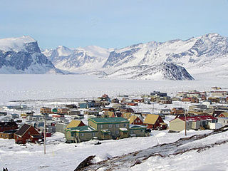
Pangnirtung is an Inuit hamlet, Qikiqtaaluk Region, in the Canadian territory of Nunavut, located on Baffin Island. As of the 2016 census the population was 1,481, an increase of 3.9% from the 2011 census. The area of the town is 7.77 km2 (3.00 sq mi). Pangnirtung is situated on a coastal plain at the coast of Pangnirtung Fjord, a fjord which eventually merges with Cumberland Sound. As of January 2014, the mayor is Mosesee Qappik.

The Qikiqtaaluk Region, Qikiqtani Region or Baffin Region is the easternmost administrative region of Nunavut, Canada. Qikiqtaaluk is the traditional Inuktitut name for Baffin Island. Although the Qikiqtaaluk Region is the most commonly used name in official contexts, several notable public organizations, including Statistics Canada prefer the older term Baffin Region.

The Queen Elizabeth Islands are the northernmost cluster of islands in Canada's Arctic Archipelago, split between Nunavut and the Northwest Territories in Northern Canada. The Queen Elizabeth Islands contain approximately 14% of the global glacier and ice cap area..

Area code 867 is the area code for the three territories in Northern Canada. It was created on October 21, 1997, from portions of area codes 403 and 819. It is the least populated mainland North American area code, serving about 100,000 people, but is the geographically largest at 3,921,739 km2 (1,514,192 sq mi). It is adjacent to Greenland, Russia, and eight provinces or states (Alaska, Alberta, British Columbia, Manitoba, Newfoundland, Ontario, Saskatchewan, and more jurisdictions than any other area code in North America. It is also one of four Canadian area codes yet to be overlaid, the others being 506, 709, and 807, for which seven-digit dialing is still used.

Lake Hazen is often called the northernmost lake of Canada, in the northern part of Ellesmere Island, Nunavut, but detailed maps show several smaller lakes up to more than 100 km (62 mi) farther north on Canada's northernmost island. Turnabout Lake is immediately northeast of the northern end of Hazen lake. Still further north are the Upper and Lower Dumbell Lakes, with Upper Dumbell Lake 5.2 km (3 mi) southwest of Alert, Canada's northernmost settlement on the coast of Lincoln Sea, Arctic Ocean.
The Arctic Cordillera is a terrestrial ecozone in northern Canada characterized by a vast, deeply dissected chain of mountain ranges extending along the northeastern flank of the Canadian Arctic Archipelago from Ellesmere Island to the northeasternmost part of the Labrador Peninsula in northern Labrador and northern Quebec, Canada. It spans most of the eastern coast of Nunavut with high glaciated peaks rising through ice fields and some of Canada's largest ice caps, including the Penny Ice Cap on Baffin Island. It is bounded to the east by Baffin Bay, Davis Strait and the Labrador Sea while its northern portion is bounded by the Arctic Ocean.

Adams Island is an uninhabited island in the Qikiqtaaluk Region of Nunavut, Canada. The island is located in Baffin Bay off the northeastern coast of Baffin Island in the Canadian Arctic Archipelago. Nearby are Dexterity Island (northeast), Dexterity Fiord and Baffin Island (east), Tromso Fiord (south), Paterson Inlet (west), Bergesen Island (northwest), and Isbjorn Strait (north).

The Borden Peninsula is a peninsula on northern Baffin Island, in Nunavut, Canada. It lies some 80 km south of Devon Island, from which it is separated by Lancaster Sound. Northeastern Borden Peninsula is home to Sirmilik National Park.
The High Arctic relocation took place during the Cold War in the 1950s, when 92 Inuit were moved by the Government of Canada under liberal Prime Minister Louis St. Laurent to the High Arctic.
The Fosheim Peninsula is located in western Ellesmere Island, a part of the Qikiqtaaluk Region of the Canadian territory of Nunavut. Eureka, a permanent research community, is located on the north side of Slidre Fiord, a few kilometers east of Eureka Sound. While the peninsula was first sighted by the Arctic explorer Adolphus Greely in 1881, it was not explored until 1899 by Otto Sverdrup, who named it after Ivar Fosheim, a member of his expedition.
The Heim Peninsula is located on the southern coast of Ellesmere Island, a part of the Qikiqtaaluk Region of the Canadian territory of Nunavut. The Sydkap Fiord is to the west, and the Harbour Fiord is to the east. Landslip Island is approximately 1 km (0.62 mi) off the southeastern shore.

Dorset Island or Cape Dorset Island is one of the Canadian Arctic islands located in Hudson Strait, Nunavut, Canada. It lies off the Foxe Peninsula area of southwestern Baffin Island in the Qikiqtaaluk Region. It is serviced by an airport and a harbour.

Craig Harbour is an abandoned settlement in Qikiqtaaluk, Nunavut, Canada. It is located on Ellesmere Island, on the north shore of Jones Sound, 55 km (34 mi) southeast of Grise Fiord.

Kangiqtualuk Uqquqti formerly Sam Ford Fiord is an isolated, elongated Arctic fjord on Baffin Island's northeastern coast in the Qikiqtaaluk Region of Nunavut, Canada. The Inuit settlement of Pond Inlet is 320 km (200 mi) to the northwest and Clyde River is 80 km (50 mi) to the east.
Arviqtujuq Kangiqtua formerly Eglinton Fiord is a fjord on Baffin Island's northeastern coast in the Qikiqtaaluk Region of Nunavut, Canada. The Inuit settlement of Pond Inlet is 355 km (221 mi) to the northwest and Clyde River is 55 km (34 mi) to the east.

The Remote Peninsula is a peninsula located on the eastern coast of Baffin Island. It is part of the Qikiqtaaluk Region of the Canadian territory of Nunavut. The Inuit settlement of Pond Inlet is 295 km (183 mi) to the northwest and Clyde River is 90 km (56 mi) to the southeast.
