Related Research Articles

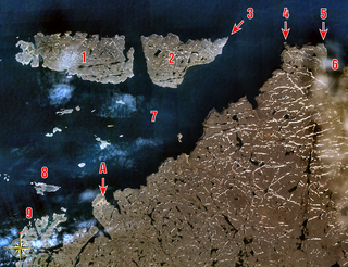
Devon Island is an island in Canada and the largest uninhabited island in the world. It is located in Baffin Bay, Qikiqtaaluk Region, Nunavut, Canada. It is one of the largest members of the Arctic Archipelago, the second-largest of the Queen Elizabeth Islands, Canada's sixth-largest island, and the 27th-largest island in the world. It has an area of 55,247 km2 (21,331 sq mi). The bedrock is Precambrian gneiss and Paleozoic siltstones and shales. The highest point is the Devon Ice Cap at 1,920 m (6,300 ft) which is part of the Arctic Cordillera. Devon Island contains several small mountain ranges, such as the Treuter Mountains, Haddington Range and the Cunningham Mountains. The notable similarity of its surface to that of Mars has attracted interest from scientists.

Akpatok Island is one of the uninhabited Canadian Arctic islands in the Qikiqtaaluk Region of Nunavut, Canada. It is the largest island in Ungava Bay on the northern coast of Quebec. The island is named for the akpat, which live on ledges along the limestone cliffs surrounding the island.

Prince Leopold Island is an island in the Qikiqtaaluk Region of Nunavut, Canada. It is located in Lancaster Sound at the junction of Prince Regent Inlet and Barrow Strait. Somerset Island is situated 13 km (8.1 mi) to the southwest; Port Leopold, an abandoned trading post, is the closest landmark. The island is significant as a summer habitat and breeding ground for large populations of several arctic bird species.

Coburg Island is an uninhabited island in Qikiqtaaluk, Nunavut, Canada. It is one of the members of Queen Elizabeth Islands located in Baffin Bay's Lady Ann Strait. It is separated from Ellesmere Island by Glacier Strait; Devon Island is to the south.
Berlinguet Inlet is a body of water adjoining Baffin Island within the Qikiqtaaluk Region of Nunavut, Canada. It runs west–east at Admiralty Inlet's southern end, separated from Bernier Bay to the west, which opens into the Gulf of Boothia, by a 1.5 km (0.93 mi) isthmus. Baffin Island's Brodeur Peninsula is to the north; Borden Peninsula is to the northeast.
Scott Inlet is a body of water in the Qikiqtaaluk Region of Nunavut, Canada. It is an arm of Baffin Bay. Scott Island lies in its middle. At its south end, it splits into Clark and Gibbs Fiords. The Inuit community of Clyde River is approximately 120 km (75 mi) to the southeast.
The Colin Archer Peninsula is located on the northwestern Devon Island, a part of the Qikiqtaaluk Region of the Canadian territory of Nunavut. It stretches eastward into Baffin Bay. It is named in honor of Colin Archer, naval architect and shipbuilder.
Digges Sound is a Canadian Arctic waterway in Qikiqtaaluk, Nunavut, Canada. The sound is located at the juncture where the Hudson Strait meets northeastern Hudson Bay close to the northern tip of the Ungava Peninsula, between Digges Islands and Cape Wolstenholme. Ivujivik, Quebec, the northernmost settlement in any Canadian province, is located on the south coast of the sound.

Dorset Island, or Cape Dorset Island, is one of the Canadian Arctic islands located in Hudson Strait, Nunavut, Canada. It lies off the Foxe Peninsula area of southwestern Baffin Island in the Qikiqtaaluk Region. It is serviced by an airport and a harbour.
Qaqulluit (Inuktitut syllabics: ᖃᖁᓪᓗᐃᑦ formerly Qaqaluit Island is one of eastern Baffin Island's small, offshore, uninhabited islands, located in the Arctic Archipelago in the Qikiqtaaluk Region, Nunavut. Along with Paallavvik and Aggijjat, it is situated off Cumberland Peninsula within Davis Strait's Merchants Bay.
Baillarge Bay is an Arctic waterway in the Qikiqtaaluk Region, Nunavut, Canada. It is the second waterway to press eastward from Admiralty Inlet into Baffin Island. The southern point of its mouth is named Ship Point.
Buchan Gulf is an isolated, elongated Arctic fjord on Baffin Island's northeastern coast in the Qikiqtaaluk Region of Nunavut, Canada. The Inuit settlement of Pond Inlet is 200 km (120 mi) to the north.
Cape Liddon is an uninhabited headland on Devon Island in the Qikiqtaaluk Region of Nunavut, Canada. It is located on the southwestern coast of the island at Radstock Bay.
Cambridge Point is an uninhabited headland on Coburg Island in the Qikiqtaaluk Region of Nunavut, Canada. It is located off Marina Peninsula.
Niaqunnguut (Inuktitut syllabics: ᓂᐊᖁᙴᑦ formerly Cape Graham Moore, after Vice-Admiral Sir Graham Moore, is an uninhabited headland on Bylot Island in the Qikiqtaaluk Region of Nunavut, Canada. It is located at the island's southeastern tip protruding into Lancaster Sound. The community of Pond Inlet is 70 km to the southwest.
Nuvuttiq (ᓄᕗᑦᑎᖅ) formerly Cape Searle is an uninhabited headland located on Qaqulluit's northeastern tip, in the Qikiqtaaluk Region of Nunavut, Canada.
The uninhabited Cheyne Islands are members of the Queen Elizabeth Islands and the Arctic Archipelago in the Qikiqtaaluk Region of Nunavut, Canada. The group is made up of three islands known as North Island, Middle Island, and South Island. Located approximately 5 km (3.1 mi) off eastern Bathurst Island, they are situated near Reindeer Bay within western Penny Strait.
Reid Bay is an Arctic waterway in the Qikiqtaaluk Region, Nunavut, Canada. It is located in Davis Strait off Baffin Island's Cumberland Sound.
Hantzsch Island is an uninhabited island in the Qikiqtaaluk Region of Nunavut, Canada. It is located in Frobisher Bay off the southern tip of Baffin Island's Meta Incognita Peninsula and the northeastern tip of Edgell Island. The closest community is the community of Iqaluit, 270 km (170 mi) northwest of Hantzsch Island.
Hobhouse Inlet is a body of water in the Qikiqtaaluk Region of Nunavut, Canada. It lies off the southern coast of Devon Island. Like Stratton Inlet, Burnett Inlet, Powell Inlet, and Cuming Inlet, Hobhouse is situated between Maxwell Bay and Croker Bay, in the eastern high Arctic, north of Lancaster Sound and Barrow Strait.
References
- ↑ Sverdrup, Otto Neumann; Per Schei; Herman Georg Simmons; Edvard Bay (1904). New land: four years in the Arctic regions. Vol. 2. Ethel Harriet Hearn (translator) (Digitized November 6, 2008 ed.). Longmans, Green, and Co. pp. 42, 474.
- ↑ "Cape Vera". bsc-eoc.org. Archived from the original on 2011-06-12. Retrieved 2009-05-04.
- ↑ "Ecological investigations of Northern Fulmars at Cape Vera, Devon Island". mb.ec.gc.ca. Archived from the original on 2009-05-10. Retrieved 2009-05-04.
76°13′59″N089°13′00″W / 76.23306°N 89.21667°W
| | This Qikiqtaaluk Region, Nunavut location article is a stub. You can help Wikipedia by expanding it. |