The geography of Canada describes the geographic features of Canada, the world's second largest country in total area.

Hudson Strait links the Atlantic Ocean and Labrador Sea to Hudson Bay in Canada. This strait lies between Baffin Island and Nunavik, with its eastern entrance marked by Cape Chidley in Quebec and Resolution Island off Baffin Island. The strait is about 750 km long with an average width of 125 km, varying from 70 km at the eastern entrance to 240 km at Deception Bay.

The Gulf of Saint Lawrence is the outlet of the North American Great Lakes via the Saint Lawrence River into the Atlantic Ocean. The gulf is a semienclosed sea, covering an area of about 226,000 square kilometres (87,000 sq mi) and containing about 34,500 cubic kilometres (8,300 cu mi) of water, which results in an average depth of 152 metres (499 ft).

The Arctic Archipelago, also known as the Canadian Arctic Archipelago, is a group of islands north of the Canadian mainland.

Baffin Bay, located between Baffin Island and the west coast of Greenland, is a marginal sea of the North Atlantic Ocean. It is connected to the Atlantic via Davis Strait and the Labrador Sea. The narrower Nares Strait connects Baffin Bay with the Arctic Ocean. The bay is not navigable most of the year because of the ice cover and high density of floating ice and icebergs in the open areas. However, a polynya of about 80,000 km2 (31,000 sq mi), known as the North Water, opens in summer on the north near Smith Sound. Most of the aquatic life of the bay is concentrated near that region.

The Pratt & Whitney R-985 Wasp Junior is a series of nine-cylinder, air-cooled, radial aircraft engines built by the Pratt & Whitney Aircraft Company from the 1930s to the 1950s. These engines have a displacement of 985 in3 (16 L); initial versions produced 300 hp (220 kW), while the most widely used versions produce 450 hp (340 kW).

CKXC-FM is a Canadian radio station broadcasting at 93.5 FM in Kingston, Ontario owned by Rogers Media. The station currently broadcasts a country music format branded as Country 93.5.

Eukaryotic translation initiation factor 4 gamma 3 is a protein that in humans is encoded by the EIF4G3 gene. The gene encodes a protein that functions in translation by aiding the assembly of the ribosome onto the messenger RNA template. Confusingly, this protein is usually referred to as eIF4GII, as although EIF4G3 is the third gene that is similar to eukaryotic translation initiation factor 4 gamma, the second isoform EIF4G2 is not an active translation initiation factor.

Spectrin, beta, non-erythrocytic 4, also known as SPTBN4, is a protein that in humans is encoded by the SPTBN4 gene.
Cape Thomas Hubbard is a headland located in the northern Canadian territory of Nunavut. Projecting into the Arctic Ocean, it is situated on the northern tip of Axel Heiberg Island, 320 mi (510 km) from Etah, Greenland.

Enon is a community in the Canadian province of Nova Scotia, located in the Cape Breton Regional Municipality on Cape Breton Island.

Wanakah is a hamlet in the town of Hamburg in Erie County, New York, United States. As of the 2010 census, it had a population of 3,199.
Cape Ludwig is a peninsula in Qikiqtaaluk Region, Nunavut, Canada. It is located on Amund Ringnes Island. Massey Sound is nearby, entered from Norwegian Bay between Cape Ludwig and Cape Southwest. Hendriksen Strait is to the southwest.
Cape Southwest is a headland in Qikiqtaaluk Region, Nunavut, Canada. It is located on Amund Ringnes Island near Cape Ludwig, where Norwegian Bay enters Massey Sound. Cape Maundy Thursday is to the northwest.
Cape Maundy Thursday is an ice-capped headland in Qikiqtaaluk Region, Nunavut, Canada. It is located on Amund Ringnes Island 21 miles (34 km) northwest of Cape Southwest. Cape Maundy Thursday rises to 845 metres (2,772 ft) above sea level.
Skrugar Point is a peninsula in Qikiqtaaluk Region, Nunavut, Canada. It is located on Amund Ringnes Island 40 miles (64 km) northwest of Cape Southwest. It rises to 290 metres (950 ft) above sea level and forms an entrance point to Sand Bay.
Cape Sverre is a peninsula in Qikiqtaaluk Region, Nunavut, Canada. Named in honor of Sverre Hassel of the 1900 Otto Sverdrup expedition, it is the northernmost point on Amund Ringnes Island.
Cape Cairo is a peninsula in Qikiqtaaluk Region, Nunavut, Canada. It is located on eastern Ellef Ringnes Island.
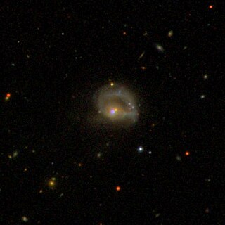
NGC 985 is a ring galaxy in the constellation of Cetus. It is located about 550 million light years away from Earth, which means, given its apparent dimensions, that NGC 985 is approximately 160,000 light years across. It was discovered by Francis Leavenworth in 1886. It is a type 1 Seyfert galaxy.