Kent Peninsula

Last updated
Kent Peninsula is south of Dease Strait Map indicating Dease Strait, Nunavut, Canada.png
Kent Peninsula is south of Dease Strait

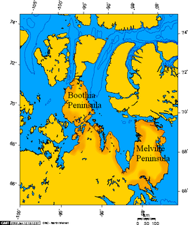
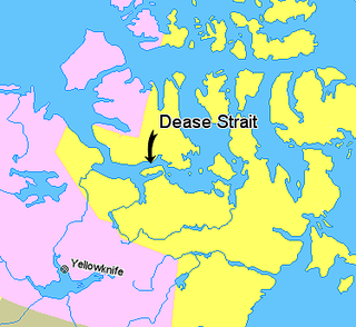
The Kent Peninsula is a large peninsula, almost totally surrounded by water, in Nunavut's northern Canadian Arctic mainland. Were it not for a 5-mile isthmus at the southeast corner it would be a long island parallel to the coast. From the isthmus it extends 105 mi (169 km) westward into the Coronation Gulf. To the south, Melville Sound separates it from the mainland. To the north is Dease Strait and then Victoria Island. To the west is Coronation Gulf and to the east, Queen Maud Gulf. Cape Flinders marks the western tip of the peninsula, Cape Franklin is at the northwestern point, and Cape Alexander marks the northeastern point. [1]

Peninsula A piece of land that is bordered by water on three sides but connected to mainland

A peninsula is a landform surrounded by water on the majority of its border while being connected to a mainland from which it extends. The surrounding water is usually understood to be continuous, though not necessarily named as a single body of water. Peninsulas are not always named as such; one can also be a headland, cape, island promontory, bill, point, or spit. A point is generally considered a tapering piece of land projecting into a body of water that is less prominent than a cape. A river which courses through a very tight meander is also sometimes said to form a "peninsula" within the loop of water. In English, the plural versions of peninsula are peninsulas and, less commonly, peninsulae.

Nunavut Territory of Canada

Nunavut is the newest, largest, and most northerly territory of Canada. It was separated officially from the Northwest Territories on April 1, 1999, via the Nunavut Act and the Nunavut Land Claims Agreement Act, though the boundaries had been drawn in 1993. The creation of Nunavut resulted in the first major change to Canada's political map since the incorporation of the province of Newfoundland in 1949.

Northern Canada Region in Canada

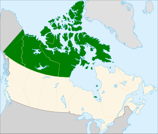
Northern Canada, colloquially the North, is the vast northernmost region of Canada variously defined by geography and politics. Politically, the term refers to three territories of Canada: Yukon, Northwest Territories, and Nunavut. Similarly, the Far North may refer to the Canadian Arctic: the portion of Canada that lies north of the Arctic Circle, east of Alaska and west of Greenland. This area covers about 39 percent of Canada's total land area, but has less than 1 percent of Canada's population.

Historically, the Umingmuktogmiut subgroup of the Copper Inuit had a permanent community at Umingmuktog on the peninsula's western coast. [2] A landmark for early explorers was Point Turnagain, located about 25 miles northeast of Cape Flinders, near Cape Franklin at about 68°36′30″N108°18′30″W / 68.60833°N 108.30833°W / 68.60833; -108.30833 . In 1821, John Franklin reached the point from the west and then turned back. In 1838, Thomas Simpson nearly reached the same point, but was blocked by ice and had to walk 100 miles east. In 1839, the coast was clear of ice and Simpson followed the entire coast eastward.

Umingmuktogmiut

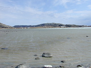
The Umingmuktogmiut are a geographically defined Copper Inuit band in the northern Canadian territory of Nunavut, Kitikmeot Region. They were located on the western coast of Kent Peninsula, and also further south in eastern Bathurst Inlet around Everitt Point by the Barry Islands. Umingmuktogmiut were notable amongst other Copper Inuit as they had a permanent community, Umingmuktog. They could hunt and fish for Arctic char, Arctic fox, barren-ground caribou, fur seals, and muskox prevalent in the area.

Copper Inuit ethnic group

Copper Inuit are a Canadian Inuit group who live north of the tree line, in what is now Nunavut's Kitikmeot Region and the Northwest Territories's Inuvik Region. Most historically lived in the area around Coronation Gulf, on Victoria Island, and southern Banks Island.

John Franklin British Royal Navy officer and Arctic explorer

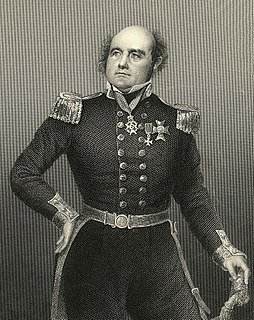
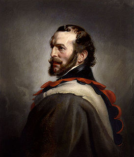
Rear Admiral Sir John Franklin was a British Royal Navy officer and explorer of the Arctic. Franklin also served as Lieutenant-Governor of Van Diemen's Land from 1837 to 1843. He disappeared while on his last expedition, attempting to chart and navigate the Northwest Passage in the North American Arctic. The icebound ships were abandoned and the entire crew died of starvation, hypothermia, tuberculosis, lead poisoning, and scurvy.

Related Research Articles

Victoria Island (Canada) island in arctic Canada

Victoria Island is a large island in the Canadian Arctic Archipelago that straddles the boundary between Nunavut and the Northwest Territories of Canada. It is the eighth largest island in the world, and at 217,291 km2 (83,897 sq mi) in area, it is Canada's second largest island. It is nearly double the size of Newfoundland (111,390 km2 [43,008 sq mi]), and is slightly larger than the island of Great Britain (209,331 km2 [80,823 sq mi]) but smaller than Honshu (225,800 km2 [87,182 sq mi]). It contains the world's largest island within an island within an island. The western third of the island belongs to the Inuvik Region in the Northwest Territories; the remainder is part of Nunavut's Kitikmeot Region.

Arctic Archipelago Canadian archipelago

The Arctic Archipelago, also known as the Canadian Arctic Archipelago, is a group of islands north of the Canadian mainland.

Lincoln National Park Protected area in South Australia

Lincoln National Park is a protected area in the Australian state of South Australia located about 249 kilometres (155 mi) west of the state capital of Adelaide and about 9.5 kilometres (5.9 mi) south of the municipal seat of Port Lincoln. It consists of a mainland area on the Jussieu Peninsula on the south eastern tip of Eyre Peninsula and a number of nearby islands. The national park contains significant sites of natural, indigenous and early European heritage.

John Rae (explorer) Scottish explorer

John Rae was a Scottish surgeon who explored parts of northern Canada, found the final portion of the Northwest Passage and reported the fate of Sir John Franklin's lost expedition. In 1846–47 he explored the Gulf of Boothia northwest of Hudson Bay. In 1848–51 he explored the Arctic coast near Victoria Island. In 1854 he went from Boothia to the Arctic coast and learned the fate of Franklin. He was noted for physical stamina, skill at hunting and boat handling, use of native methods and the ability to travel long distances with little equipment while living off the land.

Amundsen Gulf A gulf in the Northwest Territories, Canada

Amundsen Gulf is a gulf located in the Northwest Territories, Canada, between Banks Island and Victoria Island and the mainland. It is approximately 250 mi (400 km) in length and about 93 mi (150 km) across where it meets the Beaufort Sea.

Melville Peninsula peninsula in Foxe Basin (Hudson Bay), Canada

Melville Peninsula is a large peninsula in the Canadian Arctic north of Hudson Bay. To the east is Foxe Basin and to the west the Gulf of Boothia. To the north the Fury and Hecla Strait separates it from Baffin Island. To the south Repulse Bay and Frozen Strait separate it from Southampton Island at the north end of Hudson Bay. On the southwest it is connected to the mainland by the "Rae Isthmus" named after arctic explorer Dr John Rae.

Boothia Peninsula peninsula

Boothia Peninsula is a large peninsula in Nunavut's northern Canadian Arctic, south of Somerset Island. The northern part, Murchison Promontory, is the northernmost point of mainland Canada.

Coronation Gulf bay

Coronation Gulf lies between Victoria Island and mainland Nunavut in Canada. To the northwest it connects with Dolphin and Union Strait and thence the Beaufort Sea and Arctic Ocean; to the northeast it connects with Dease Strait and thence Queen Maud Gulf.

Dease Strait strait

Dease Strait is an east-west waterway between the mainland's Kent Peninsula and Victoria Island in Nunavut, Canada. At its eastern end, approximately 12 mi (19 km) wide, is Cambridge Bay; to the west it widens to approximately 38 mi (61 km) and becomes Coronation Gulf. The strait is 100 mi (160 km) long.

Banks Peninsula (Nunavut) peninsula in Nunavut, Canada

The Banks Peninsula is located on the mainland of Canada's Nunavut territory. There are no communities on the peninsula, though the hamlet of Bathurst Inlet is located close-by, to the south, across the waterway of Bathurst Inlet. The peninsula has an irregular coastline, including a portion bounded by Arctic Sound. Point Wollaston is the northern most geographic feature.

Sutton Island is located in northern Canada's territory of Nunavut. It is situated in the Dolphin and Union Strait immediately next to Liston/Listen Island. Rymer Point and Simpson Bay, on Victoria Island's Wollaston Peninsula are to the northeast. Bernard Harbour, on the mainland, is to the southwest, as is Chantrey Island.

Cape Baring is a Canadian Arctic headland in the Northwest Territories. The most westerly point of the Wollaston Peninsula, it is located on Victoria Island, protruding into the Amundsen Gulf.

Lady Franklin Point is a landform in the Canadian Arctic territory of Nunavut. It is located on southwestern Victoria Island in the Coronation Gulf by Austin Bay at the eastern entrance of Dolphin and Union Strait.

Thomas Simpson was an arctic explorer, Hudson's Bay Company agent and cousin of HBC governor Sir George Simpson. His violent death in what is now the state of Minnesota—allegedly by suicide after gunning down two traveling companions in the wilderness—has long been a subject of controversy.

Cape Barrow cape in Canada

.

Franklin Bay bay in Northwest Territories, Canada

Franklin Bay is a large inlet in the Northwest Territories, Canada. It is a southern arm of the Amundsen Gulf, southeastern Beaufort Sea. The bay measures 48 kilometres (30 mi) long, and 40 kilometres (25 mi) wide at its mouth. The Parry Peninsula is to the east, and its southern area is called Langton Bay.

The Kilusiktogmiut were a Copper Inuit subgroup. They lived on Victoria Island, east of the Nagyuktogmiut who were known to inhabit the area northeast of Lady Franklin Point. They also lived on the mainland along the Coronation Gulf, particularly at the mouth of the Mackenzie River. They spent at least some time on the Banks Peninsula by Bathurst Inlet.

Cape Flinders is a headland in the northern Canadian territory of Nunavut. It is located on the western point of the Kent Peninsula.

Nuussuaq Peninsula is a mainland peninsula in northwestern Greenland, located at the northern end of Upernavik Archipelago, approximately 70 km (43 mi) to the south of Melville Bay. It is much smaller than its namesake in western Greenland.

References

  1. McGoogan, Ken (2003). Fatal Passage: The Story of John Rae, the Arctic Hero Time Forgot. Basic Books. p. 139. ISBN   0-7867-1156-6.
  2. Stefansson, Vilhjalmur (1914). The Stefánsson-Anderson Arctic Expedition of the American Museum: Preliminary Ethnological Report. New York: The Trustees of the American Museum. p. 28. OCLC   13626409.

Coordinates: 68°30′N107°00′W / 68.500°N 107.000°W / 68.500; -107.000 (Kent Peninsula)

Geographic coordinate system Coordinate system

A geographic coordinate system is a coordinate system that enables every location on Earth to be specified by a set of numbers, letters or symbols. The coordinates are often chosen such that one of the numbers represents a vertical position and two or three of the numbers represent a horizontal position; alternatively, a geographic position may be expressed in a combined three-dimensional Cartesian vector. A common choice of coordinates is latitude, longitude and elevation. To specify a location on a plane requires a map projection.