
Sir Edward Sabine was an Irish astronomer, geophysicist, ornithologist, explorer, soldier and the 30th president of the Royal Society.

William Eaton Chandler, also known as Bill Chandler, was a lawyer who served as United States Secretary of the Navy and as a U.S. Senator from New Hampshire. In the 1880s, he was a member of the Republican "Half-Breed" faction, the wing of the party which advocated civil service reform. His credentials were established as moderate in comparison to most of the Republican Party, particularly in his opposition towards sound money.

Adolphus Washington Greely was a United States Army officer and polar explorer. He attained the rank of major general and was a recipient of the Medal of Honor.

SY Aurora was a 580-ton barque-rigged steam yacht built by Alexander Stephen and Sons Ltd. in Dundee, Scotland, in 1876, for the Dundee Seal and Whale Fishing Company. It was 165 feet (50 m) long with a 30-foot (9.1 m) beam. The hull was made of oak, sheathed with greenheart and lined with fir. The bow was a mass of solid wood reinforced with steel-plate armour. The heavy side frames were braced by two levels of horizontal oak beams. Its primary use was whaling in the northern seas, and it was built sturdily enough to withstand the heavy weather and ice that would be encountered there. That strength proved useful for Antarctic exploration as well and between 1911 and 1917 it made five trips to the continent, both for exploration and rescue missions.
Edward Israel was an astronomer and Polar explorer.
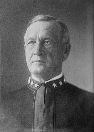
Uriel Sebree was a career officer in the United States Navy. He entered the Naval Academy during the Civil War and served until 1910, retiring as a rear admiral. He is best remembered for his two expeditions into the Arctic and for serving as acting governor of American Samoa. He was also commander-in-chief of the Pacific Fleet.

McClintock Island is an island in Franz Josef Land, Russia.
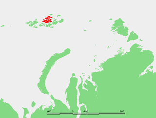
Ziegler Island is an island in Franz Josef Land, Russia.
Sabine Island is an island to the northeast of Wollaston Foreland, previously known as Inner Pendulum Island. It is in the Northeast Greenland National Park area.

Pim Island is an uninhabited island located off the eastern coast of Ellesmere Island, part of the Qikiqtaaluk Region of the Canadian territory of Nunavut. Located within the Arctic Archipelago, it is a part of the Queen Elizabeth Islands.
Cocked Hat Island, located off the eastern coast of Ellesmere Island, is a part of the Qikiqtaaluk Region of the Canadian territory of Nunavut. The island is located within the Arctic Archipelago, and is a part of the Queen Elizabeth Islands.
Norman Lockyer Island is located off the eastern coast of Ellesmere Island, and a part of the Qikiqtaaluk Region of the Canadian territory of Nunavut. Situated in Princess Marie Bay just in front of Franklin Pierce Bay, 9 km (5.6 mi) WSW of Cape Prescott, north of Bache Peninsula, Norman Lockyer Island is within the Arctic Archipelago, a member of the Queen Elizabeth Islands.
Lady Franklin Bay is an Arctic waterway in Qikiqtaaluk Region, Nunavut, Canada. The bay is located in Nares Strait northwest of Judge Daly Promontory and is an inlet into the northeastern shore of Ellesmere Island.

The Lady Franklin Bay Expedition of 1881–1884 to Lady Franklin Bay on Ellesmere Island in the Canadian Arctic was led by Lieutenant Adolphus Greely, and was promoted by the United States Army Signal Corps. Its purpose was to establish a meteorological-observation station as part of the First International Polar Year, and to collect astronomical and magnetic data. During the expedition, two members of the crew reached a new Farthest North record, but of the original twenty-five men, only seven survived to return.

HMS Alert was a 17-gun wooden screw sloop of the Cruizer class of the Royal Navy, launched in 1856 and broken up in 1894. She was the eleventh ship of the Royal Navy to bear the name, and was noted for her Arctic exploration work; in 1876 she reached a record latitude of 82° North. Alert briefly served with the US Navy, and ended her career with the Canadian Marine Service as a lighthouse tender and buoy ship.
Dobbin Bay is an Arctic waterway in Qikiqtaaluk Region, Nunavut, Canada. It is located in Nares Strait by eastern Ellesmere Island, south of the Darling Peninsula.
James Booth Lockwood was a United States Army officer and arctic explorer.
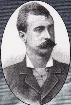
George Walter Rice was a British North America-born photographer who was first to photograph the Arctic region on the ill-fated American led Lady Franklin Bay Expedition of 1881 to 1884. Rice died in the Arctic on 9 April 1884 while awaiting the arrival of a relief vessel.

Kane Island is an island in Franz Josef Land, Arkhangelsk Oblast, Russian Arctic.

