
Baffin Island, in the Canadian territory of Nunavut, is the largest island in Canada, the second-largest island in the Americas, and the fifth-largest island in the world. Its area is 507,451 km2 (195,928 sq mi) with a population density of 0.03/km2; the population was 13,039 according to the 2021 Canadian census; and it is located at 68°N70°W. It also contains the city of Iqaluit, which is the capital of Nunavut.

Victoria Island is a large island in the Arctic Archipelago that straddles the boundary between Nunavut and the Northwest Territories of Canada. It is the eighth-largest island in the world, and at 217,291 km2 (83,897 sq mi)1 in area, it is Canada's second-largest island. It is nearly double the size of Newfoundland (111,390 km2 [43,010 sq mi]), and is slightly larger than the island of Great Britain (209,331 km2 [80,823 sq mi]) but smaller than Honshu (225,800 km2 [87,200 sq mi]). The western third of the island lies in the Inuvik Region of the Northwest Territories; the remainder is part of Nunavut's Kitikmeot Region. The population of 2,168 is divided between two settlements, the larger of which is Cambridge Bay (Nunavut) and the other Ulukhaktok.
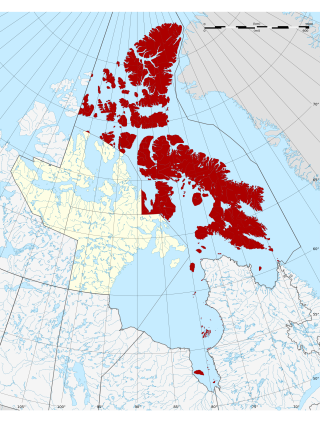
The Qikiqtaaluk Region, Qikiqtani Region or the Baffin Region is the easternmost, northernmost, and southernmost administrative region of Nunavut, Canada. Qikiqtaaluk is the traditional Inuktitut name for Baffin Island. Although the Qikiqtaaluk Region is the most commonly used name in official contexts, several notable public organizations, including Statistics Canada prior to the 2021 Canadian census, use the older term Baffin Region.

The Kivalliq Region is an administrative region of Nunavut, Canada. It consists of the portion of the mainland to the west of Hudson Bay together with Southampton Island and Coats Island. The regional centre is Rankin Inlet. The population was 11,045 in the 2021 Canadian census, an increase of 6.1% from the 2016 Census.

Southampton Island is a large island at the entrance to Hudson Bay at Foxe Basin. One of the larger members of the Arctic Archipelago, Southampton Island is part of the Kivalliq Region in Nunavut, Canada. The area of the island is stated as 41,214 km2 (15,913 sq mi) by Statistics Canada. It is the 34th largest island in the world and Canada's ninth largest island. The only settlement on Southampton Island is Coral Harbour, called Salliq in Inuktitut.

Bylot Island lies off the northern end of Baffin Island in Nunavut Territory, Canada. Eclipse Sound to the southeast and Navy Board Inlet to the southwest separate it from Baffin Island. Parry Channel lies to its northwest. At 11,067 km2 (4,273 sq mi) it is ranked 71st largest island in the world and Canada's 17th largest island. The island measures 180 km (110 mi) east to west and 110 km (68 mi) north to south and is one of the largest uninhabited islands in the world. While there are no permanent settlements on this Canadian Arctic island, Inuit from Pond Inlet and elsewhere regularly travel to Bylot Island. An Inuit seasonal hunting camp is located southwest of Cape Graham Moore.

Sirmilik National Park is a national park located in Qikiqtaaluk, Nunavut, Canada, established in 1999. Situated within the Arctic Cordillera, the park is composed of three areas: most of Bylot Island with the exception for a few areas that are Inuit-owned lands, Kangiqłuruluk, and Baffin Island's Borden Peninsula. Much of the park is bordered by water.

Prince Regent Inlet is a body of water in Nunavut, Canada between the west end of Baffin Island and Somerset Island on the west. It opens north into Lancaster Sound and to the south merges into the Gulf of Boothia. The Arctic inlet's northern portion is approximately 40 mi (64 km) wide; the southern portion is approximately 65 mi (105 km) wide. It is deep throughout and there are no islands within the inlet.

Qikiqtaaluk (ᕿᑭᖅᑖᓗᒃ) formerly Sillem Island is an uninhabited island in the Qikiqtaaluk Region of Nunavut, Canada. It is the second largest of the several hundred islands and islets that are located in Baffin Bay, immediately off the northern coast of Baffin Island. It is defined by Clark and Gibbs Fiords, which join at its northern end to form Scott Inlet. Further north lies Pilattuaq.

Amadjuak Lake is a lake in the Qikiqtaaluk Region, Nunavut, Canada. Along with Nettilling Lake, it is located in south-central Baffin Island's Great Plain of the Koukdjuak. It is 154 km (96 mi) south of Burwash Bay. The closest community is Iqaluit.

Adams Island is an uninhabited island in the Qikiqtaaluk Region of Nunavut, Canada. The island is located in Baffin Bay off the northeastern coast of Baffin Island in the Arctic Archipelago. Nearby are Dexterity Island (northeast), Dexterity Fiord and Baffin Island (east), Tromso Fiord (south), Paterson Inlet (west), Bergesen Island (northwest), and Isbjorn Strait (north).
Berlinguet Inlet is a body of water adjoining Baffin Island within the Qikiqtaaluk Region of Nunavut, Canada. It runs west–east at Admiralty Inlet's southern end, separated from Bernier Bay to the west, which opens into the Gulf of Boothia, by a 1.5 km (0.93 mi) isthmus. Baffin Island's Brodeur Peninsula is to the north; Borden Peninsula is to the northeast.
Jackson Inlet is a body of water in Nunavut's Qikiqtaaluk Region. It lies east of Lancaster Sound and cuts into Baffin Island's Brodeur Peninsula.

Milne Inlet is a small, shallow arm of Eclipse Sound which, along with Navy Board Inlet, separates Bylot Island from Baffin Island in Nunavut's Qikiqtaaluk Region. Milne Inlet flows in a southerly direction from Navy Board Inlet at the confluence of Eclipse Sound. Milne Inlet is shallow and has high tides and strong winds. It only has 90 days where it is ice-free—from August to October. The hamlet of Mittimatalik —Pond Inlet which is 92% Inuit, is the gateway to many tourist attractions in the region, and is 80 km from Milne Inlet. The region is part of the Arctic Cordillera, with one of Canada's most inhospitable climates—with long, dark winters and temperatures averaging −35 °C (−31 °F).

The Borden Peninsula is a peninsula on northern Baffin Island, in Nunavut, Canada. It lies some 80 km south of Devon Island, from which it is separated by Lancaster Sound. Northeastern Borden Peninsula is home to Sirmilik National Park.
Buchan Gulf is an isolated, elongated Arctic fjord on Baffin Island's northeastern coast in the Qikiqtaaluk Region of Nunavut, Canada. The Inuit settlement of Pond Inlet is 200 km (120 mi) to the north.

Cape Hay is an uninhabited headland on Bylot Island in the Qikiqtaaluk Region of Nunavut, Canada. It is located at the island's northwestern tip, protruding into Lancaster Sound. The Wollaston Islands are offshore.
Aulitivik Island is an uninhabited island located in the Qikiqtaaluk Region of Nunavut, Canada. It is located in Baffin Bay's Isabella Bay by the Davis Strait. Situated north of Baffin Island's Henry Kater Peninsula, it is a member of the Arctic Archipelago. Aulitiving Island is 19.5 km (12.1 mi) to the east, with tiny Bearslide Island lying between them.
Aulitiving Island is an uninhabited island located in the Qikiqtaaluk Region of Nunavut, Canada. It is located in Baffin Bay's Isabella Bay by the Davis Strait. It is situated north of Baffin Island's Henry Kater Peninsula. Aulitivik Island is 19.5 km (12.1 mi) to the west, with tiny Bearslide Island lying between them.
Kangiqtualuk Uqquqti formerly Sam Ford Fiord is an isolated, elongated Arctic fjord on Baffin Island's northeastern coast in the Qikiqtaaluk Region of Nunavut, Canada. The Inuit settlement of Pond Inlet is 320 km (200 mi) to the northwest and Clyde River is 80 km (50 mi) to the east.
