The Northwest Passage (NWP) is the sea lane between the Atlantic and Pacific oceans through the Arctic Ocean, along the northern coast of North America via waterways through the Canadian Arctic Archipelago. The eastern route along the Arctic coasts of Norway and Siberia is accordingly called the Northeast Passage (NEP). The various islands of the archipelago are separated from one another and from Mainland Canada by a series of Arctic waterways collectively known as the Northwest Passages, Northwestern Passages or the Canadian Internal Waters.

Victoria Island is a large island in the Arctic Archipelago that straddles the boundary between Nunavut and the Northwest Territories of Canada. It is the eighth-largest island in the world, and at 217,291 km2 (83,897 sq mi) in area, it is Canada's second-largest island. It is nearly double the size of Newfoundland (111,390 km2 [43,010 sq mi]), and is slightly larger than the island of Great Britain (209,331 km2 [80,823 sq mi]) but smaller than Honshu (225,800 km2 [87,200 sq mi]). The western third of the island lies in the Inuvik Region of the Northwest Territories; the remainder is part of Nunavut's Kitikmeot Region. The population of 2,168 is divided among 2 settlements, the larger of which is in Nunavut and the other of which is in the Northwest Territories.

The Arctic Archipelago, also known as the Canadian Arctic Archipelago, is an archipelago lying to the north of the Canadian continental mainland, excluding Greenland and Iceland.
Sir William Edward Parry was an Royal Navy officer and explorer best known for his 1819–1820 expedition through the Parry Channel, probably the most successful in the long quest for the Northwest Passage, until it was finally negotiated by Roald Amundsen in 1906. In 1827, Parry attempted one of the earliest expeditions to the North Pole. He reached 82° 45' N, setting a record for human exploration Farthest North that stood for nearly five decades before being surpassed at 83° 20' N by Albert Hastings Markham in 1875.

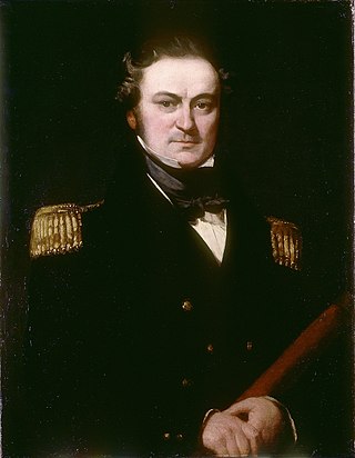
Sir John Ross was a Scottish Royal Navy officer and polar explorer. He was the uncle of Sir James Clark Ross, who explored the Arctic with him, and later led expeditions to Antarctica.

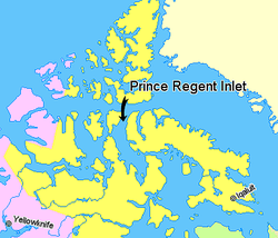
Somerset Island is a large, uninhabited island of the Arctic Archipelago, that is part of the Canadian territory of Nunavut. The island is separated from Cornwallis Island and Devon Island to the north by the Parry Channel, from Baffin Island to the east by Prince Regent Inlet, from the Boothia Peninsula to the south by Bellot Strait, and from Prince of Wales Island to the west by Peel Sound. It has an area of 24,786 km2 (9,570 sq mi), making it the 46th largest island in the world and Canada's twelfth largest island.

King William Island is an island in the Kitikmeot Region of Nunavut, which is part of the Arctic Archipelago. In area it is between 12,516 km2 (4,832 sq mi) and 13,111 km2 (5,062 sq mi) making it the 61st-largest island in the world and Canada's 15th-largest island. Its population, as of the 2021 census, was 1,349, all of whom live in the island's only community, Gjoa Haven.

Henry Asbjørn Larsen was a Norwegian-Canadian Arctic explorer. Larsen was born on a small island, Herføl, south of Fredrikstad in Norway. Like his hero, Roald Amundsen, he became a seaman. Larsen immigrated to Canada, and became a British subject in 1927. In 1928, he joined the Royal Canadian Mounted Police (RCMP).

Melville Peninsula is a large peninsula in the Canadian Arctic north of Hudson Bay. To the east is Foxe Basin and to the west the Gulf of Boothia. To the north the Fury and Hecla Strait separates it from Baffin Island. To the south Repulse Bay and Frozen Strait separate it from Southampton Island at the north end of Hudson Bay. On the southwest it is connected to the mainland by the Rae Isthmus, named after the Arctic explorer John Rae.

Boothia Peninsula is a large peninsula in Nunavut's northern Canadian Arctic, south of Somerset Island. The northern part, Murchison Promontory, is the northernmost point of mainland Canada.

HMS Hecla was a Royal Navy Hecla-class bomb vessel launched in 1815. Like many other bomb vessels, she was named for a volcano, in this case Hekla in southern Iceland. She served at the Bombardment of Algiers in 1816. Subsequently, she took part in three expeditions to the Arctic. She then served as a survey vessel on the coast of West Africa until she was sold in 1831. She became a merchantman and in 1834 a Greenland whaler. She was wrecked in 1840.

James Ross Strait, an arm of the Arctic Ocean, is a channel between King William Island and the Boothia Peninsula in the Canadian territory of Nunavut. 180 km (110 mi) long, and 48 km (30 mi) to 64 km (40 mi) wide, it connects M'Clintock Channel to the Rae Strait to the south. Islands in the channel include the Clarence Islands, Tennent Islands, Beverley Island, and Matty Island.

The Prince of Wales Strait is a strait in the Northwest Territories of Canada separating Banks Island to the northwest from Victoria Island to the southeast. It extends from Viscount Melville Sound in the northeast to Amundsen Gulf in the southwest. From late winter it is filled by ice that usually does not break up until August, if at all. Its namesake, Prince of Wales Island, lies over 200 mi (320 km) to the east.

The Gulf of Boothia is a body of water in Nunavut, Canada. Administratively it is divided between the Kitikmeot Region on the west and the Qikiqtaaluk Region on the east. It merges north into Prince Regent Inlet, the two forming a single bay with different names for its parts. It is surrounded by, clockwise, Baffin Island, Fury and Hecla Strait, the Melville Peninsula, the Canadian mainland, and the Boothia Peninsula. The south end is Committee Bay, northwest of which are the Simpson Peninsula and Pelly Bay.
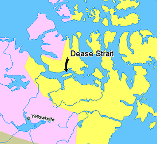
Dease Strait is an east–west waterway between the mainland's Kent Peninsula and Victoria Island in Nunavut, Canada. It is part of the Northwest Passage. At its eastern end, approximately 19 km (12 mi) wide, is Cambridge Bay; to the west it widens to approximately 61 km (38 mi) and becomes Coronation Gulf. The strait is 163 km (101 mi) long.
Bellot Strait is a strait in Nunavut that separates Somerset Island to its north from the Murchison Promontory of Boothia Peninsula to its south, which is the northernmost part of the mainland of the Americas. The two-kilometre-wide (1.2 mi) and 25-kilometre-long (16 mi) strait connects the Gulf of Boothia, Prince Regent Inlet, and Brentford Bay to its east with Peel Sound and Franklin Strait to its west.
Victoria Strait is a strait in northern Canada that lies in Nunavut off the mainland in the Arctic Ocean. It is between Victoria Island to the west and King William Island to the east. From the north, the strait links the M'Clintock Channel and the Larsen Sound with the Queen Maud Gulf to the south. The strait is about 160 km (100 mi) long and anywhere from 80 to 130 km wide.

Barrow Strait is a shipping waterway in Northern Canada's territory of Nunavut. Forming part of the Parry Channel, the strait separates several large islands including Cornwallis Island and Devon Island to the north, from Prince of Wales Island, Somerset Island, and Prince Leopold Island to the south.

The Parry Channel is a natural waterway through the central Canadian Arctic Archipelago. Its eastern two-thirds lie in the territory of Nunavut, while its western third lies in the Northwest Territories. It runs east to west, connecting Baffin Bay in the east with the Beaufort Sea in the west. Its eastern end is the only practical entrance to the Northwest Passage. Its western end would be a natural exit from the archipelago were it not filled with ice. The channel separates the Queen Elizabeth Islands to the north from the rest of Nunavut.

The Canadian Arctic Rift System is a major North American geological structure extending from the Labrador Sea in the southeast through Davis Strait, Baffin Bay and the Arctic Archipelago in the northwest. It consists of a series of interconnected rifts that formed during the Paleozoic, Mesozoic and Cenozoic eras. Extensional stresses along the entire length of the rift system have resulted in a variety of tectonic features, including grabens, half-grabens, basins and faults.