Related Research Articles
Sir William Edward Parry was a Royal Navy officer and explorer best known for his 1819–1820 expedition through the Parry Channel, probably the most successful in the long quest for the Northwest Passage, until it was finally negotiated by Roald Amundsen in 1906. In 1827, Parry attempted one of the earliest expeditions to the North Pole. He reached 82° 45' N, setting a record for human exploration Farthest North that stood for nearly five decades before being surpassed at 83° 20' N by Albert Hastings Markham in 1875.

Somerset Island is a large, uninhabited island of the Arctic Archipelago, that is part of the Canadian territory of Nunavut. The island is separated from Cornwallis Island and Devon Island to the north by the Parry Channel, from Baffin Island to the east by Prince Regent Inlet, from the Boothia Peninsula to the south by Bellot Strait, and from Prince of Wales Island to the west by Peel Sound. It has an area of 24,786 km2 (9,570 sq mi), making it the 46th largest island in the world and Canada's twelfth largest island.

Bylot Island lies off the northern end of Baffin Island in Nunavut Territory, Canada. Eclipse Sound to the southeast and Navy Board Inlet to the southwest separate it from Baffin Island. Parry Channel lies to its northwest. At 11,067 km2 (4,273 sq mi) it is ranked 71st largest island in the world and Canada's 17th largest island. The island measures 180 km (110 mi) east to west and 110 km (68 mi) north to south and is one of the largest uninhabited islands in the world. While there are no permanent settlements on this Canadian Arctic island, Inuit from Pond Inlet and elsewhere regularly travel to Bylot Island. An Inuit seasonal hunting camp is located southwest of Cape Graham Moore.

Melville Peninsula is a large peninsula in the Canadian Arctic north of Hudson Bay. To the east is Foxe Basin and to the west the Gulf of Boothia. To the north the Fury and Hecla Strait separates it from Baffin Island. To the south Repulse Bay and Frozen Strait separate it from Southampton Island at the north end of Hudson Bay. On the southwest it is connected to the mainland by the Rae Isthmus, named after the Arctic explorer John Rae.

HMS Hecla was a Royal Navy Hecla-class bomb vessel launched in 1815. Like many other bomb vessels, she was named for a volcano, in this case Hekla in southern Iceland. She served at the Bombardment of Algiers in 1816. Subsequently, she took part in three expeditions to the Arctic. She then served as a survey vessel on the coast of West Africa until she was sold in 1831. She became a merchantman and in 1834 a Greenland whaler. She was wrecked in 1840.
HMS Fury was a Hecla-class bomb vessel of the British Royal Navy.

The Gulf of Boothia is a body of water in Nunavut, Canada. Administratively it is divided between the Kitikmeot Region on the west and the Qikiqtaaluk Region on the east. It merges north into Prince Regent Inlet, the two forming a single bay with different names for its parts. It is surrounded by, clockwise, Baffin Island, Fury and Hecla Strait, the Melville Peninsula, the Canadian mainland, and the Boothia Peninsula. The south end is Committee Bay, northwest of which are the Simpson Peninsula and Pelly Bay. On the west side of the gulf at 70°18′N91°42′W, north of Pelly Bay and Thom Bay, is Eden Bay, which should not be confused with a bay of the same name in the Qikiqtaaluk Region.

Prince Regent Inlet is a body of water in Nunavut, Canada between the west end of Baffin Island and Somerset Island on the west. It opens north into Lancaster Sound and to the south merges into the Gulf of Boothia. The Arctic inlet's northern portion is approximately 40 mi (64 km) wide; the southern portion is approximately 65 mi (105 km) wide. It is deep throughout and there are no islands within the inlet.

Fury and Hecla Strait is a narrow Arctic seawater channel located in the Qikiqtaaluk Region of Nunavut, Canada.
Tasiujaq formerly Murray Maxwell Bay is an uninhabited waterway in the Qikiqtaaluk Region, Nunavut, Canada. It is located in the Foxe Basin, north of Siuraarjuk on Baffin Island. The island of Kapuiviit lies at the opening of the bay.
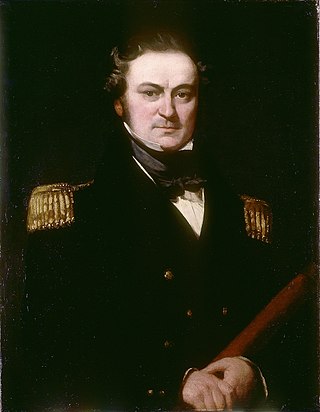
Captain Henry Parkyns Hoppner was an officer of the Royal Navy, Arctic explorer, draughtsman and artist. His career included two ill-fated voyages culminating in the loss of HMS Alceste in 1816 and HMS Fury in 1825.
Hoppner may refer to:
The Hoppner River flows northward from Wollaston Peninsula into Dolphin and Union Strait at the juncture with the Amundsen Gulf in Nunavut, Canada. Long-tailed duck frequent the area.
Hoppner Strait is a narrow arm of Foxe Basin east of Lyon Inlet in the Qikiqtaaluk Region of Nunavut, Canada. It is situated between Winter Island and the Melville Peninsula.

Winter Island is an uninhabited island of the Arctic Archipelago in the Qikiqtaaluk Region, Nunavut. It lies in the Foxe Basin with Hoppner Strait to the northwest. Winter Island is south of the Melville Peninsula, separated from it by Lyon Inlet. William Edward Parry wintered here at the end of 1821.
Stratton Inlet is a body of water in the Qikiqtaaluk Region of Nunavut, Canada.
Cuming Inlet is a body of water in the Qikiqtaaluk Region of Nunavut, Canada. It lies off the southern coast of Devon Island in the eastern high Arctic. Like Stratton Inlet, Burnett Inlet, Hobhouse Inlet, and Powell Inlet, Cuming Inlet is situated between Maxwell Bay and Croker Bay, north of Lancaster Sound and Barrow Strait.
Griffin Inlet is a body of water in the Qikiqtaaluk Region of Nunavut, Canada. Situated in Wellington Channel, it lies north of Cape Bowden, off the southwestern coast of Devon Island, in the eastern high Arctic.

Cape Parry is a headland in Canada's Northwest Territories. Located at the northern tip of the Parry Peninsula, it projects into Amundsen Gulf. The nearest settlement is Paulatuk, 100 km (62 mi) to the south, and Fiji Island is located 9 km (5.6 mi) to the west. Cape Parry was formerly accessible through Cape Parry Airport that was located at the Distant Early Warning Line. The airport was listed as abandoned after the closure of the DEW line site.

Thomas Abernethy was a Scottish seafarer, gunner in the Royal Navy, and polar explorer. Because he was neither an officer nor a gentleman, he was little mentioned in the books written by the leaders of the expeditions he went on, but was praised in what was written. In 1857, he was awarded the Arctic Medal for his service as an able seaman on the 1824–25 voyage of HMS Hecla, the first of his five expeditions for which participants were eligible for the award. He was in parties that, for their time, reached the furthest north, the furthest south (twice), and the nearest to the South Magnetic Pole. In 1831, along with James Clark Ross's team of six, Abernethy was in the first party ever to reach the North Magnetic Pole.
References
- ↑ Halpenny, F.G.; Holland, C. (1966). Dictionary of Canadian biography. Toronto: University of Toronto Press. pp. 229–230. ISBN 0-8020-3142-0.