Related Research Articles

Baffin Island, in the Canadian territory of Nunavut, is the largest island in Canada and the fifth-largest island in the world. Its area is 507,451 km2 (195,928 sq mi) with a population density of 0.03/km²; the population was 13,039 according to the 2021 Canadian census; and it is located at 68°N70°W. It also contains the city of Iqaluit, which is the capital of Nunavut.

The Arctic Archipelago, also known as the Canadian Arctic Archipelago, is an archipelago lying to the north of the Canadian continental mainland, excluding Greenland and Iceland.
Frobisher Bay is an inlet of the Davis Strait in the Qikiqtaaluk Region of Nunavut, Canada. It is located in the southeastern corner of Baffin Island. Its length is about 230 km (140 mi) and its width varies from about 40 km (25 mi) at its outlet into the Davis Strait to roughly 20 km (12 mi) towards its inner end.

Igloolik is an Inuit hamlet in Foxe Basin, Qikiqtaaluk Region in Nunavut, northern Canada. Because its location on Igloolik Island is close to Melville Peninsula, it is often mistakenly thought to be on the peninsula. The name "Igloolik" means "there is a house here". It derives from iglu meaning house or building, and refers to the sod houses that were originally in the area, not to snow igloos. In Inuktitut the residents are called Iglulingmiut.

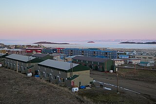
Pond Inlet is a small, predominantly Inuit community in the Qikiqtaaluk Region of Nunavut, Canada, located on northern Baffin Island. To the Inuit the name of the place "is and always has been Mittimatalik." The Scottish explorer Sir John Ross had named an arm of the sea that separates Bylot Island from Baffin Island as Pond's Bay, and the hamlet now shares that name. On 29 August 1921, the Hudson's Bay Company opened its trading post near the Inuit camp and named it Pond Inlet, marking the expansion of its trading empire into the High Arctic.

Baffin Bay, located between Baffin Island and the west coast of Greenland, is defined by the International Hydrographic Organization as a marginal sea of the Arctic Ocean. It is sometimes considered a sea of the North Atlantic Ocean. It is connected to the Atlantic via Davis Strait and the Labrador Sea. The narrower Nares Strait connects Baffin Bay with the Arctic Ocean. The bay is not navigable most of the year because of the ice cover and high density of floating ice and icebergs in the open areas. However, a polynya of about 80,000 km2 (31,000 sq mi), known as the North Water, opens in summer on the north near Smith Sound. Most of the aquatic life of the bay is concentrated near that region.

Bylot Island lies off the northern end of Baffin Island in Nunavut Territory, Canada. Eclipse Sound to the southeast and Navy Board Inlet to the southwest separate it from Baffin Island. Parry Channel lies to its northwest. At 11,067 km2 (4,273 sq mi) it is ranked 71st largest island in the world and Canada's 17th largest island. The island measures 180 km (110 mi) east to west and 110 km (68 mi) north to south and is one of the largest uninhabited islands in the world. While there are no permanent settlements on this Canadian Arctic island, Inuit from Pond Inlet and elsewhere regularly travel to Bylot Island. An Inuit seasonal hunting camp is located southwest of Cape Graham Moore.

Foxe Basin is a shallow oceanic basin north of Hudson Bay, in Nunavut, Canada, located between Baffin Island and the Melville Peninsula. For most of the year, it is blocked by sea ice and drift ice made up of multiple ice floes.

Nunavut is the largest and northernmost territory of Canada. It was separated officially from the Northwest Territories on April 1, 1999, via the Nunavut Act and the Nunavut Land Claims Agreement Act, which provided this territory to the Inuit for independent government. The boundaries had been drawn in 1993. The creation of Nunavut resulted in the first major change to Canada's political map in half a century since the province of Newfoundland was admitted in 1949.
Mary River is located on Baffin Island in the Qikiqtaaluk Region of Nunavut, about 936 km (582 mi) northwest of the capital, Iqaluit, and about 176 km (109 mi) southwest of Pond Inlet Inuktitut: Mittimatalik, lit. 'the place where the landing place is' The Inuit, name for the Mary River mountain is Nuluyait, meaning buttocks. There is a 4,000 year history in the area. For hundreds of years the semi-nomadic Inuit from the region that includes the hamlets of Pond Inlet and Igloolik, met at Mary River during the summer hunting caribou. By 2011, the population of the region was about 5,400 people, many of whom continued the traditional hunting and fishing lifestyle living off the land.

Milne Inlet is a small, shallow arm of Eclipse Sound which, along with Navy Board Inlet, separates Bylot Island from Baffin Island in Nunavut's Qikiqtaaluk Region. Milne Inlet flows in a southerly direction from Navy Board Inlet at the confluence of Eclipse Sound. Milne Inlet is shallow and has high tides and strong winds. It only has 90 days where it is ice-free—from August to October. The hamlet of Mittimatalik —Pond Inlet which is 92% Inuit, is the gateway to many tourist attractions in the region, and is 80 km from Milne Inlet. The region is part of the Arctic Cordillera, with one of Canada's most inhospitable climates—with long, dark winters and temperatures averaging −35 °C (−31 °F).

Kangiqtugaapik formerly Clyde Inlet is a body of water in eastern Baffin Island, Qikiqtaaluk Region, Nunavut. Its mouth opens into the Davis Strait from the west.
The Mary River Mine is an open pit iron ore mine on Inuit Owned Land (IOL) operated by the Baffinland Iron Mines Corporation (BIMC), in the Mary River area of the Qikiqtaaluk Region, on Baffin Island, Nunavut, in the Canadian Arctic Archipelago. As of 2021, Mary River mine operation consists of an open-pit mine, two work camps for hundreds of workers, a tote road—from the Mary River site to Milne Inlet—and a port infrastructure at Milne Inlet. According to a 4-year study published in 2008, the Mary River Mine, with its four massive iron ore deposits of 65-70% pure iron ore was "one of the most promising undeveloped iron deposits on the planet". It was not until technological advances were in place in 2010, and the market for iron ore had dramatically increased that sizable financial backing for the high cost of development in a remote region known for its inhospitable climate, was available. The mine began operations in 2014, and the first shipment to Europe arrived in 2015. Baffinland is currently planning on expanding the mine. In February 2021, a group of Inuit hunters blockaded access to the mine for a week to protest the expansion.

The Obskaya–Bovanenkovo Line is a 572-kilometre long (355 mi) railway line in northern Russia, built and owned and operated by Gazprom. It was opened for traffic in 2010 and was built for the gas fields around Bovanenkovo on the Yamal Peninsula, the Yamal project. In February 2011, it was extended to the Karskaya station, making it 572 km long. Like most railways in the former Russian Empire, it is built to Russian gauge.
Jowdat Waheed is a senior Canadian mining executive and Chartered Financial Analyst. Waheed worked as Chief Executive Officer of mining company Sherritt. He resigned, for personal reasons, in 2009.
The Isua Iron Mine is a proposed mine in Greenland.
Nunavik is an icebreaking bulk carrier owned and operated by the Canadian shipping company Fednav. She is used to transport copper and nickel from the Nunavik Nickel Project, making 7–8 round trips per year.
Federal Tiber is a bulk carrier. It was the first freighter to ship iron ore from the Baffinland mines, out of Milne Inlet, on its way to Nordenham, Germany, on August 8, 2015. CBC North reported it carried 53,624 tonnes of ore.
Nordic Odin is a panamax bulk carrier owned by Nordic Bulk Carriers. She was built by Oshima Shipbuilding of Saikai, Japan. She was delivered on February 13, 2015. The operation and management of the vessel is contracted out to Unicom Management of Cyprus. Her gross tonnage is 41,071; her deadweight tonnage is 76,180 tonnes.
Nordic Bulk Carriers is a Danish shipping firm that operates large bulk carriers in northern waters. The firm was founded in 2009 by Christian Bonfils and Mads Boye Petersen. Bonfils resigned in January 2015, and the firm was acquired by Pangaea Logistics Solutions.
References
- ↑ Dyke, A.S. (2008). "The Steensby Inlet Ice Stream in the context of the deglaciation of Northern Baffin Island, Eastern Arctic Canada". Earth Surface Processes and Landforms . CGRG Bibliography of Canadian Geomorphology. 33 (4). Archived from the original on 2011-08-13. Retrieved 2008-10-01.
- ↑ McCreary, Gordon A. (2007-03-28). "Our 2007 Objectives" (PDF). baffinland.com. p. 12. Archived from the original on 2012-07-09. Retrieved 2008-10-01.
{{cite web}}: CS1 maint: bot: original URL status unknown (link) - ↑ Carolyn Fitzpatrick (2008-07-24). "Heavy haul in the high north". Railway Gazette International. Archived from the original on 2009-05-01. Retrieved 2008-08-10.
70°10′N078°25′W / 70.167°N 78.417°W
| | This Qikiqtaaluk Region, Nunavut location article is a stub. You can help Wikipedia by expanding it. |