
Victoria Island is a large island in the Canadian Arctic Archipelago that straddles the boundary between Nunavut and the Northwest Territories of Canada. It is the eighth largest island in the world, and at 217,291 km2 (83,897 sq mi) in area, it is Canada's second largest island. It is nearly double the size of Newfoundland (111,390 km2 [43,008 sq mi]), and is slightly larger than the island of Great Britain (209,331 km2 [80,823 sq mi]) but smaller than Honshu (225,800 km2 [87,182 sq mi]). It contains the world's largest island within an island within an island. The western third of the island belongs to the Inuvik Region in the Northwest Territories; the remainder is part of Nunavut's Kitikmeot Region.

The Gulf of Saint Lawrence is the outlet of the North American Great Lakes via the Saint Lawrence River into the Atlantic Ocean. The gulf is a semi-enclosed sea, covering an area of about 226,000 square kilometres (87,000 sq mi) and containing about 34,500 cubic kilometres (8,300 cu mi) of water, which results in an average depth of 152 metres (499 ft).

The Arctic Archipelago, also known as the Canadian Arctic Archipelago, is a group of islands north of the Canadian mainland.
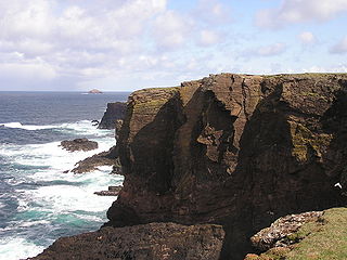
The Mainland is the main island of Shetland, Scotland. The island contains Shetland's only burgh, Lerwick, and is the centre of Shetland's ferry and air connections.

Wellesley Island in Jefferson County, New York, United States is partially in the Town of Orleans and partially in the Town of Alexandria.
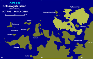
Kolosovykh Island is an island, in the Kara Sea off the coast of Siberia.
The Bjorne Peninsula is located on the western coast of Ellesmere Island, a part of the Qikiqtaaluk Region of the Canadian territory of Nunavut. It protrudes northwest into Norwegian Bay from the island's mainland. Goose Point, a narrow isthmus, is the furthest northwest landform. Other areas of the peninsula include Schei Point (north), Little Bear Cape (west), and Great Bear Cape (southwest). The peninsula's midsection is approximately 144 m (472 ft) above sea level.
The Svendsen Peninsula is located on the southwestern coast of Ellesmere Island, a part of the Qikiqtaaluk Region of the Canadian territory of Nunavut. Much of it is shielded from Norwegian Bay by the Raanes Peninsula (northwest) and Bjorne Peninsula (southwest). The Svendsen Peninsula is notable for its many fiords, including Trold, Baumann, and Vendom. Gryte Bay is in the west. Hoved Island lies offshore.
The Knud Peninsula is located on the eastern coast of Ellesmere Island, a part of the Qikiqtaaluk Region of the Canadian territory of Nunavut. It stretches eastward into Nares Strait. It is separated from the Bache Peninsula by Flagler Bay.
The Johan Peninsula is located on the eastern coast of Ellesmere Island, a part of the Qikiqtaaluk Region of the Canadian territory of Nunavut. It stretches eastward into Nares Strait. Buchanan Bay is to the north, Rosse Bay to the east, and Baird Inlet lies to the south.
Ulvingen Island is one of the uninhabited islands in Qikiqtaaluk Region, Nunavut, Canada. It is located in Norwegian Bay between Axel Heiberg Island and Ellesmere Island's Raanes Peninsula. It is a member of the Sverdrup Islands, Queen Elizabeth Islands, and the Canadian Arctic Archipelago. Hare Point is situated at the island's southern tip.
The Gretha Islands are an uninhabited island group located in the Qikiqtaaluk Region of Nunavut, Canada. They are situated in Eureka Sound at the confluence of Bay Fjord, north of Ellesmere Island's Raanes Peninsula, and east of Stor Island. They are members of the Sverdrup Islands group, Queen Elizabeth Islands, and the Canadian Arctic Archipelago.

Inuksuk Point is small peninsula on Foxe Peninsula, Baffin Island in Nunavut, Canada.

Sims Island is a small but conspicuous island between Rydberg Peninsula and Case Island in the southern part of Carroll Inlet, off the coast of Palmer Land. Discovered by pilot Ashley Snow of United States Antarctic Service (USAS) (1939–1941) on an aircraft flight, December 22, 1940. Named for Lieutenant (j.g.) L.S. Sims, United States Marine Corps (USMC), surgeon on the expedition.

The North Magnetic Pole is the wandering point on the surface of Earth's Northern Hemisphere at which the planet's magnetic field points vertically downwards. There is only one location where this occurs, near the Geographic North Pole and the Geomagnetic North Pole.
Blue Man Cape is a peninsula in the Qikiqtaaluk Region, Nunavut, Canada. It is located on Ellesmere Island.
Skrugar Point is a peninsula in Qikiqtaaluk Region, Nunavut, Canada. It is located on Amund Ringnes Island 40 miles (64 km) northwest of Cape Southwest. It rises to 290 metres (950 ft) above sea level and forms an entrance point to Sand Bay.
Cape Sverre is a peninsula in Qikiqtaaluk Region, Nunavut, Canada. Named in honor of Sverre Hassel of the 1900 Otto Sverdrup expedition, it is the northernmost point on Amund Ringnes Island.
Cape Cairo is a peninsula in Qikiqtaaluk Region, Nunavut, Canada. It is located on eastern Ellef Ringnes Island.


