
The Hudson Strait links the Atlantic Ocean and the Labrador Sea to Hudson Bay in Canada. This strait lies between Baffin Island and Nunavik, with its eastern entrance marked by Cape Chidley in Newfoundland and Labrador and Resolution Island off Baffin Island. The strait is about 750 km long with an average width of 125 km, varying from 70 km at the eastern entrance to 240 km at Deception Bay.

Victoria Island is a large island in the Arctic Archipelago that straddles the boundary between Nunavut and the Northwest Territories of Canada. It is the eighth-largest island in the world, and at 217,291 km2 (83,897 sq mi) in area, it is Canada's second-largest island. It is nearly double the size of Newfoundland (111,390 km2 [43,010 sq mi]), and is slightly larger than the island of Great Britain (209,331 km2 [80,823 sq mi]) but smaller than Honshu (225,800 km2 [87,200 sq mi]). The western third of the island lies in the Inuvik Region of the Northwest Territories; the remainder is part of Nunavut's Kitikmeot Region. The population of 2,168 is divided among 2 settlements, the larger of which is in Nunavut and the other of which is in the Northwest Territories.

The Arctic Archipelago, also known as the Canadian Arctic Archipelago, is an archipelago lying to the north of the Canadian continental mainland, excluding Greenland and Iceland.

The Dorset was a Paleo-Eskimo culture, lasting from 500 BCE to between 1000 CE and 1500 CE, that followed the Pre-Dorset and preceded the Thule people (proto-Inuit) in the North American Arctic. The culture and people are named after Cape Dorset in Nunavut, Canada, where the first evidence of its existence was found. The culture has been defined as having four phases due to the distinct differences in the technologies relating to hunting and tool making. Artifacts include distinctive triangular end-blades, oil lamps made of soapstone, and burins.

Southampton Island is a large island at the entrance to Hudson Bay at Foxe Basin. One of the larger members of the Arctic Archipelago, Southampton Island is part of the Kivalliq Region in Nunavut, Canada. The area of the island is stated as 41,214 km2 (15,913 sq mi) by Statistics Canada. It is the 34th largest island in the world and Canada's ninth largest island. The only settlement on Southampton Island is Coral Harbour, called Salliq in Inuktitut.

Coats Island lies at the northern end of Hudson Bay in the Kivalliq Region of Nunavut. At 5,498 km2 (2,123 sq mi) in size, it is the 107th largest island in the world, and Canada's 24th largest island.
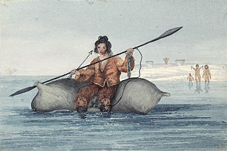
The Sadlermiut were an Inuit group living in near isolation mainly on and around Coats Island, Walrus Island, and Southampton Island in Hudson Bay. They survived into the early 20th century and were thought by some to have been the last remnants of the Dorset culture as they had preserved a culture and dialect distinct from the mainland Inuit. Despite their culture and local traditions seeming to show combined elements of both the Dorset and Thule societies, genetic studies show no Dorset admixture and prove a sole Inuit ancestry leading many to conclude the cultural difference may be entirely due to their isolation from the mainland Inuit. Research published in 2015 found that the Sadlermiut were genetically Thule who had somehow acquired Dorset cultural features, such as stone technology. It remains a mystery how they acquired Dorset technology in the absence of obvious genetic admixture such as through intermarrying.

HMS Terror was a specialised warship and a newly developed bomb vessel constructed for the Royal Navy in 1813. She participated in several battles of the War of 1812, including the Battle of Baltimore with the bombardment of Fort McHenry. She was converted into a polar exploration ship two decades later, and participated in George Back's Arctic expedition of 1836–1837, the successful Ross expedition to the Antarctic of 1839 to 1843, and Sir John Franklin's ill-fated attempt to force the Northwest Passage in 1845, during which she was lost with all hands along with HMS Erebus.

Coral Harbour is a small Inuit community that is located on Southampton Island, Kivalliq Region, in the Canadian territory of Nunavut. Its name is derived from the fossilized coral that can be found around the waters of the community which is situated at the head of South Bay. The name of the settlement in Inuktitut is Salliq, sometimes used to refer to all of Southampton Island. The plural Salliit, means large flat island(s) in front of the mainland.
The Ottawa Islands are a group of currently uninhabited islands situated in the eastern edge of Canada's Hudson Bay. The group comprises 24 small islands, located at approximately 60N 80W. The main islands include Booth Island, Bronson Island, Eddy Island, Gilmour Island, J. Gordon Island, Pattee Island, and Perley Island. The highest point is on Gilmour Island, which rises to over 1,800 ft (550 m). Located a short distance off the northwest coast of Quebec's Ungava Peninsula, they, like the other coastal islands in Hudson Bay, were historically part of the Northwest Territories, and became Crown Land upon the creation of Nunavut in 1999. Nunavik Inuit have occupied these islands since time immemorial and gained constitutionally-protected harvest and access rights under the Nunavik Inuit Land Claim Agreement signed in 2007.
The A. T. Gifford was the last American schooner-rigged whaleship to cruise Hudson Bay. She caught fire and sank in late 1915. Although the captain and a few of his crew escaped the wreck, none survived the disaster.

Cape Fullerton is a cape and peninsula in the Kivalliq Region of Nunavut, Canada located on the northwest shores of Hudson Bay on Roes Welcome Sound and includes Fullerton Harbour. Today it is part of Ukkusiksalik National Park. Although Cape Fullerton was traditionally home to migrant Inuit including the Aivilingmiut and the Qaernermiut, today the nearest permanently populated settlement is Chesterfield Inlet, roughly 100 km (62 mi) to the southwest.

Captain George Comer was considered the most famous American whaling captain of Hudson Bay, and the world's foremost authority on Hudson Bay Inuit in the early 20th century.
Comer's Midden was a 1916 archaeological excavation site near Thule, north of Mt. Dundas in North Star Bay in northern Greenland. It is the find after which the Thule culture was named. The site was first excavated in 1916 by whaling Captain George Comer, ice master of the Crocker Land Expedition's relief team, and of members of Knud Rasmussen's Second Danish Thule Expedition who were in the area charting the North Greenland coast.
The Back Peninsula is a cape located on eastern Bell Peninsula, Southampton Island, in the Kivalliq Region, Nunavut, Canada. Its southern shore is part of the northern boundary of Hudson Bay. Foxe Basin is to the north. There are two large bays, Gorden Bay and Junction Bay. Bowhead whale frequent the area. The Bell Peninsula's irregular coastline is marked by Seashore Point and Expectation Point.

Dorset Island or Cape Dorset Island is one of the Canadian Arctic islands located in Hudson Strait, Nunavut, Canada. It lies off the Foxe Peninsula area of southwestern Baffin Island in the Qikiqtaaluk Region. It is serviced by an airport and a harbour.
Igloolik Island is a small island in the Qikiqtaaluk Region of Nunavut, Canada. It is located in the Foxe Basin, very close to the Melville Peninsula, and it is often thought to be a part of the peninsula. It forms part of the Arctic Archipelago.
Native Bay is a waterway in Kivalliq Region, Nunavut, Canada. It is located in Hudson Bay off western Southampton Island. The Bell Peninsula lies to the southeast. Native Point is located at the bay's southern tip. East Bay is 20 km (12 mi) to the east.
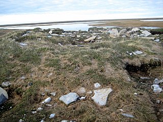
Native Point is a peninsula in the Kivalliq Region, Nunavut, Canada. It is located on Southampton Island's Bell Peninsula at the mouth of Native Bay. It is notable for being the location of an abandoned Sadlermiut settlement, currently an archaeological site.

Dundas Harbour is an abandoned settlement in the Qikiqtaaluk Region, Nunavut, Canada. It is located on Devon Island at the eastern shore of the waterway also named Dundas Harbour. Baffin Bay's Croker Bay is immediately to the west.
