Oganesson is a synthetic chemical element with symbol Og and atomic number 118. It was first synthesized in 2002 at the Joint Institute for Nuclear Research (JINR) in Dubna, near Moscow in Russia, by a joint team of Russian and American scientists. In December 2015, it was recognized as one of four new elements by the Joint Working Party of the international scientific bodies IUPAC and IUPAP. It was formally named on 28 November 2016. The name is in line with the tradition of honoring a scientist, in this case the nuclear physicist Yuri Oganessian, who has played a leading role in the discovery of the heaviest elements in the periodic table. It is one of only two elements named after a person who was alive at the time of naming, the other being seaborgium; it is also the only element whose namesake is alive today.

The Gulf of Saint Lawrence is the outlet of the North American Great Lakes via the Saint Lawrence River into the Atlantic Ocean. The gulf is a semienclosed sea, covering an area of about 226,000 square kilometres (87,000 sq mi) and containing about 34,500 cubic kilometres (8,300 cu mi) of water, which results in an average depth of 152 metres (499 ft).

The Arctic Archipelago, also known as the Canadian Arctic Archipelago, is a group of islands north of the Canadian mainland.
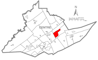
Zion is an unincorporated community and census-designated place (CDP) in Centre County, Pennsylvania, United States. It is part of the State College, Pennsylvania Metropolitan Statistical Area. The population was 2,030 at the 2010 census.

Rimersburg is a borough in Clarion County in the U.S. state of Pennsylvania. The population was 951 at the 2010 census.

The Northwest Angle, known simply as the Angle by locals, and coextensive with Angle Township, is a part of northern Lake of the Woods County, Minnesota. Except for minor surveying errors, it is the only place in the United States outside Alaska that is north of the 49th parallel, which forms the border between the U.S. and Canada from the Northwest Angle westward to the Strait of Georgia. The land area of the Angle is separated from the rest of Minnesota by Lake of the Woods, but shares a land border with Canada. It is one of the only six non-island locations in the 48 contiguous states that are practical exclaves of the U.S. It is the northernmost township in Minnesota and contains the northernmost point in the contiguous 48 states. The unincorporated community of Angle Inlet is located in the Northwest Angle.

The Canada lynx is a lynx species native to North America. It ranges across Canada and Alaska extending into the Rocky Mountains and New Mexico. It has been listed as Least Concern on the IUCN Red List since 2002.

Baffin Bay, located between Baffin Island and the west coast of Greenland, is a marginal sea of the North Atlantic Ocean. It is connected to the Atlantic via Davis Strait and the Labrador Sea. The narrower Nares Strait connects Baffin Bay with the Arctic Ocean. The bay is not navigable most of the year because of the ice cover and high density of floating ice and icebergs in the open areas. However, a polynya of about 80,000 km2 (31,000 sq mi), known as the North Water, opens in summer on the north near Smith Sound. Most of the aquatic life of the bay is concentrated near that region.
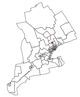
Newmarket—Aurora is a federal electoral district in Ontario, Canada, that has been represented in the House of Commons of Canada since 2004.

Athabasca Pass is a high mountain pass in the Canadian Rockies. It is the headwaters of the Whirlpool River, a tributary of the Athabasca River. In fur-trade days it connected Jasper House on the Athabasca River with Boat Encampment on the Columbia River.

WAAL is a commercial FM radio station licensed to Binghamton, New York. It airs a classic rock radio format and is owned by Townsquare Media. WAAL is the oldest FM radio station in the Binghamton metropolitan area. It is an affiliate of the New York Giants Radio Network.
The Bjorne Peninsula is located on the western coast of Ellesmere Island, a part of the Qikiqtaaluk Region of the Canadian territory of Nunavut. It protrudes northwest into Norwegian Bay from the island's mainland. Goose Point, a narrow isthmus, is the furthest northwest landform. Other areas of the peninsula include Schei Point (north), Little Bear Cape (west), and Great Bear Cape (southwest). The peninsula's midsection is approximately 144 m (472 ft) above sea level.

Aetna is a hamlet in southern Alberta, Canada within Cardston County, located 2 kilometres (1.2 mi) east of Highway 2, approximately 70 kilometres (43 mi) southwest of Lethbridge.
Cape Parry is a headland in Canada's Northwest Territories. Located at the northern tip of the Parry Peninsula, it projects into Amundsen Gulf. The nearest settlement is Paulatuk, 100 km (62 mi) to the south, and Fiji Island is located 9 km (5.6 mi) to the west. Cape Parry was formerly accessible through Cape Parry Airport that was located at the Distant Early Warning Line. The airport was listed as abandoned after the closure of the DEW line site.
Blue Man Cape is a peninsula in the Qikiqtaaluk Region, Nunavut, Canada. It is located on Ellesmere Island.
Cape Southwest is a headland in Qikiqtaaluk Region, Nunavut, Canada. It is located on Amund Ringnes Island near Cape Ludwig, where Norwegian Bay enters Massey Sound. Cape Maundy Thursday is to the northwest.
Cape Maundy Thursday is an ice-capped headland in Qikiqtaaluk Region, Nunavut, Canada. It is located on Amund Ringnes Island 21 miles (34 km) northwest of Cape Southwest. Cape Maundy Thursday rises to 845 metres (2,772 ft) above sea level.
Skrugar Point is a peninsula in Qikiqtaaluk Region, Nunavut, Canada. It is located on Amund Ringnes Island 40 miles (64 km) northwest of Cape Southwest. It rises to 290 metres (950 ft) above sea level and forms an entrance point to Sand Bay.
Cape Levvel is a peninsula in Qikiqtaaluk Region, Nunavut, Canada. It is located on Amund Ringnes Island by Strand Bay. From steep cliffs, it rises to 120 metres (390 ft) above sea level.

The 2017 Pacific hurricane season was an event in the annual cycle of tropical cyclone formation, in which tropical cyclones form in the eastern Pacific Ocean. The season officially started on May 15 in the eastern Pacific—east of 140°W—and on June 1 in the central Pacific—between the International Date Line and 140°W—and ended on November 30. These dates typically cover the period of each year when most tropical cyclones form in the eastern Pacific basin.