Bibliography
- Mills, William James (2003). Exploring Polar Frontiers: A Historical Encyclopedia. ABC-CLIO. ISBN 1576074226.
| | This Qikiqtaaluk Region, Nunavut location article is a stub. You can help Wikipedia by expanding it. |
Hendriksen Strait ( 77°50′N096°30′W / 77.833°N 96.500°W ) is a natural waterway through the Canadian Arctic Archipelago in the territory of Nunavut. It separates Amund Ringnes Island (to the north) from Cornwall Island (to the south). To the east, the sound opens into Norwegian Bay. It is 10 km (6.2 mi) wide and 40 km long.
| | This Qikiqtaaluk Region, Nunavut location article is a stub. You can help Wikipedia by expanding it. |

Victoria Island is a large island in the Arctic Archipelago that straddles the boundary between Nunavut and the Northwest Territories of Canada. It is the eighth-largest island in the world, and at 217,291 km2 (83,897 sq mi) in area, it is Canada's second-largest island. It is nearly double the size of Newfoundland (111,390 km2 [43,010 sq mi]), and is slightly larger than the island of Great Britain (209,331 km2 [80,823 sq mi]) but smaller than Honshu (225,800 km2 [87,200 sq mi]). The western third of the island lies in the Inuvik Region of the Northwest Territories; the remainder is part of Nunavut's Kitikmeot Region. The population of 2,168 is divided among two settlements, the larger of which is Cambridge Bay (Nunavut) and the other Ulukhaktok.

The Arctic Archipelago, also known as the Canadian Arctic Archipelago, is an archipelago lying to the north of the Canadian continental mainland, excluding Greenland and Iceland.

Baffin Bay, located between Baffin Island and the west coast of Greenland, is defined by the International Hydrographic Organization as a marginal sea of the Arctic Ocean. It is sometimes considered a sea of the North Atlantic Ocean. It is connected to the Atlantic via Davis Strait and the Labrador Sea. The narrower Nares Strait connects Baffin Bay with the Arctic Ocean. The bay is not navigable most of the year because of the ice cover and high density of floating ice and icebergs in the open areas. However, a polynya of about 80,000 km2 (31,000 sq mi), known as the North Water, opens in summer on the north near Smith Sound. Most of the aquatic life of the bay is concentrated near that region.

James Ross Strait, an arm of the Arctic Ocean, is a channel between King William Island and the Boothia Peninsula in the Canadian territory of Nunavut. 180 km (110 mi) long, and 48 km (30 mi) to 64 km (40 mi) wide, it connects M'Clintock Channel to the Rae Strait to the south. Islands in the channel include the Clarence Islands, Tennent Islands, Beverley Island, and Matty Island.
Borchgrevink Glacier is a large glacier in the Victory Mountains, Victoria Land, Antarctica. It drains south between Malta Plateau and Daniell Peninsula, and thence projects into Glacier Strait, Ross Sea, as a floating glacier tongue.
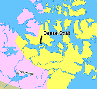
Dease Strait is an east–west waterway between the mainland's Kent Peninsula and Victoria Island in Nunavut, Canada. It is part of the Northwest Passage. At its eastern end, approximately 19 km (12 mi) wide, is Cambridge Bay; to the west it widens to approximately 61 km (38 mi) and becomes Coronation Gulf. The strait is 163 km (101 mi) long.
Pedro Bank is a large bank of sand and coral, partially covered with seagrass, about 80 km south and southwest of Jamaica, rising steeply from a seabed of 800 metres depth. It slopes gently from the Pedro Cays to the west and north with depths from 13 to 30 metres. The total area of the bank within the 100-metre (328-foot) isobath measures 8,040 square kilometres. The area of a depth to 40 metres is triangular, 70 kilometres long east-west, and 43 kilometres wide. 2,400 square kilometres are less than 20 metres deep. With its islets, cays and rocks, a total land area of 270,000 m2 (2,906,256 sq ft), it is the location of one of the two offshore island groups of Jamaica, the other one being the Morant Cays. The bank is centered at 17°06′N78°20′W.
Naajaat is a settlement in Avannaata municipality in northwestern Greenland. Former spellings include Naujât, Naujat, and Naajat. Located on a small island of the same name, the settlement has 49 inhabitants as of 2020.
The Gran Campo Nevado is a small ice field located in the southern portion of the Muñoz Gamero Peninsula, in Chile. It is about 200 km2 (77 sq mi) in area and feeds 19 outlet glaciers, of which the largest one is 15 km (9.3 mi) long.

Avery Plateau is an ice-covered plateau, about 40 miles (64 km) long and rising to about 2,000 metres (6,600 ft), midway between Loubet Coast and Foyn Coast in Graham Land, Antarctica. It borders Hemimont Plateau on the south and Bruce Plateau on the north. The first sighting of this plateau is not certain, but it was presumably seen in January and February 1909 by members of the French Antarctic Expedition under Jean-Baptiste Charcot from various positions in the Matha Strait. It was surveyed in 1946–47 by the Falkland Islands Dependencies Survey, and named by the UK Antarctic Place-Names Committee (1955) after Captain George Avery, master of the cutter Lively, who, with Captain John Biscoe in the brig Tula, approached this part of the Antarctic Peninsula in February 1832.
Frozen Strait is a waterway in Nunavut just north of Hudson Bay between the Melville Peninsula to the north and Southampton Island to the south. It connects Repulse Bay to the west with Foxe Basin to the east. The strait is 80 km (50 mi) long, and 19 to 32 km wide.
The Franklin Strait is an Arctic waterway in Northern Canada's territory of Nunavut. It is located between southeastern Prince of Wales Island and the Boothia Peninsula. It is on the south end of Peel Sound.
The Pullen Strait is a natural waterway through the central Canadian Arctic Archipelago in the territory of Nunavut. It separates Little Cornwallis Island from Cornwallis Island, and is named after William Pullen.
Maclean Strait is a natural waterway through the Canadian Arctic Archipelago in the territory of Nunavut. It separates the Findlay Group from Ellef Ringnes Island and King Christian Island.
The Hazen Strait is a natural waterway through the Canadian Arctic Archipelago. It separates Mackenzie King Island in the Northwest Territories from Vesey Hamilton Island and Melville Island's Sabine Peninsula in Nunavut.
The Humboldt Channel is a natural waterway through the central Canadian Arctic Archipelago in Kitikmeot Region, Nunavut. It separates King William Island from the Tennent Islands. To the north the strait opens into the James Ross Strait; to the south it opens into the Rae Strait.
Ikertooq Fjord is a 55 km (34 mi) long fjord in the Qeqqata municipality in western Greenland. The fjord empties into Davis Strait 21 km (13 mi) south of Sisimiut.
Schollaert Channel is a channel in the Antarctic between Anvers Island on the southwest and Brabant Island on the northeast, connecting Dallmann Bay and Gerlache Strait, in the Palmer Archipelago. It was discovered in 1898 by the Belgian Antarctic Expedition under Gerlache, who named it for the Belgian statesman Frans Schollaert.
Cape Ludwig is a peninsula in Qikiqtaaluk Region, Nunavut, Canada. It is located on Amund Ringnes Island. Massey Sound is nearby, entered from Norwegian Bay between Cape Ludwig and Cape Southwest. Hendriksen Strait is to the southwest.