Cardigan Strait

Last updated

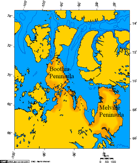
Cardigan Strait is a narrow waterway in the territory of Nunavut. It lies between the eastern coast of Devon Island and the western coast of Ellesmere Island. Norwegian Bay opens to the north. North Kent Island is situated within the strait.

Waterway Any navigable body of water

A waterway is any navigable body of water. Broad distinctions are useful to avoid ambiguity, and disambiguation will be of varying importance depending on the nuance of the equivalent word in other languages. A first distinction is necessary between maritime shipping routes and waterways used by inland water craft. Maritime shipping routes cross oceans and seas, and some lakes, where navigability is assumed, and no engineering is required, except to provide the draft for deep-sea shipping to approach seaports (channels), or to provide a short cut across an isthmus; this is the function of ship canals. Dredged channels in the sea are not usually described as waterways. There is an exception to this initial distinction, essentially for legal purposes, see under international waters.

Nunavut Territory of Canada

Nunavut is the newest, largest, and most northerly territory of Canada. It was separated officially from the Northwest Territories on April 1, 1999, via the Nunavut Act and the Nunavut Land Claims Agreement Act, though the boundaries had been drawn in 1993. The creation of Nunavut resulted in the first major change to Canada's political map since incorporating the province of Newfoundland in 1949.

Devon Island Island in Baffin Bay, Qikiqtaaluk Region, Nunavut, Canada

Devon Island is an island in Canada and the largest uninhabited island on Earth. It is located in Baffin Bay, Qikiqtaaluk Region, Nunavut, Canada. It is one of the larger members of the Canadian Arctic Archipelago, the second-largest of the Queen Elizabeth Islands, Canada's sixth-largest island, and the 27th-largest island in the world. It comprises 55,247 km2 (21,331 sq mi) of Precambrian gneiss and Paleozoic siltstones and shales. The highest point is the Devon Ice Cap at 1,920 m (6,300 ft) which is part of the Arctic Cordillera. Devon Island contains several small mountain ranges, such as the Treuter Mountains, Haddington Range and the Cunningham Mountains. The notable similarity of its surface to that of Mars has attracted interest from scientists.

A polynya forms in Cardigan Strait most winters, used by wintering Bearded and Ringed seals, polar bears, and walrus. It's also frequented in the early portion of the breeding season by seabirds. [1]

Polynya An area of unfrozen sea within the ice pack

A polynya is an area of open water surrounded by sea ice. It is now used as geographical term for an area of unfrozen sea within the ice pack. It is a loanword from Russian: полынья (polynya) Russian pronunciation: [pəɫɨˈnʲja], which refers to a natural ice hole, and was adopted in the 19th century by polar explorers to describe navigable portions of the sea.

Pinniped Infraorder of mammals

Pinnipeds, commonly known as seals, are a widely distributed and diverse clade of carnivorous, fin-footed, semiaquatic marine mammals. They comprise the extant families Odobenidae, Otariidae, and Phocidae. There are 33 extant species of pinnipeds, and more than 50 extinct species have been described from fossils. While seals were historically thought to have descended from two ancestral lines, molecular evidence supports them as a monophyletic lineage. Pinnipeds belong to the order Carnivora and their closest living relatives are believed to be bears and the superfamily of musteloids, having diverged about 50 million years ago.

Polar bear Species of bear native largely within the Arctic Circle

The polar bear is a hypercarnivorous bear whose native range lies largely within the Arctic Circle, encompassing the Arctic Ocean, its surrounding seas and surrounding land masses. It is a large bear, approximately the same size as the omnivorous Kodiak bear. A boar weighs around 350–700 kg (772–1,543 lb), while a sow is about half that size. Polar bears are the largest land carnivores currently in existence, rivaled only by the Kodiak bear. Although it is the sister species of the brown bear, it has evolved to occupy a narrower ecological niche, with many body characteristics adapted for cold temperatures, for moving across snow, ice and open water, and for hunting seals, which make up most of its diet. Although most polar bears are born on land, they spend most of their time on the sea ice. Their scientific name means "maritime bear" and derives from this fact. Polar bears hunt their preferred food of seals from the edge of sea ice, often living off fat reserves when no sea ice is present. Because of their dependence on the sea ice, polar bears are classified as marine mammals.

Related Research Articles

Victoria Island (Canada) island in arctic Canada

Victoria Island is a large island in the Canadian Arctic Archipelago that straddles the boundary between Nunavut and the Northwest Territories of Canada. It is the eighth largest island in the world, and at 217,291 km2 (83,897 sq mi) in area, it is Canada's second largest island. It is nearly double the size of Newfoundland (111,390 km2 [43,008 sq mi]), and is slightly larger than the island of Great Britain (209,331 km2 [80,823 sq mi]) but smaller than Honshu (225,800 km2 [87,182 sq mi]). It contains the world's largest island within an island within an island. The western third of the island belongs to the Inuvik Region in the Northwest Territories; the remainder is part of Nunavut's Kitikmeot Region.

Upper Mahantongo Township, Schuylkill County, Pennsylvania Township in Pennsylvania, United States

Upper Mahantongo Township is a township in Schuylkill County, Pennsylvania, United States. The population was 652 at the 2000 census.

Baffin Bay A marginal sea between Greenland and Baffin Island, Canada

Baffin Bay, located between Baffin Island and the west coast of Greenland, is a marginal sea of the North Atlantic Ocean. It is connected to the Atlantic via Davis Strait and the Labrador Sea. The narrower Nares Strait connects Baffin Bay with the Arctic Ocean. The bay is not navigable most of the year because of the ice cover and high density of floating ice and icebergs in the open areas. However, a polynya of about 80,000 km2 (31,000 sq mi), known as the North Water, opens in summer on the north near Smith Sound. Most of the aquatic life of the bay is concentrated near that region.

Davis Strait A northern arm of the Arctic Ocean that lies between mid-western Greenland and Nunavut, Canadas Baffin Island

Davis Strait is a northern arm of the Labrador Sea. It lies between mid-western Greenland and Nunavut, Canada's Baffin Island. To the north is Baffin Bay. The strait was named for the English explorer John Davis (1550–1605), who explored the area while seeking a Northwest Passage. By the 1650s it was used for whale hunting.

Gwaʼsala-ʼNakwaxdaʼxw Nations

The Gwa'Sala-Nakwaxda'xw Nations are a union of two Kwakwaka'wakw peoples in a band government based on northern Vancouver Island in British Columbia, Canada, whose main reserve community is near the town of Port Hardy in the Queen Charlotte Strait region of the Central Coast region of British Columbia, Canada. The band government is a member of the Kwakiutl District Council and, for treaty negotiation purposes, the Winalagalis Treaty Group which includes three other members of the Kwakiutl District Council.

The Transglobe Expedition was the first expedition to make a circumpolar navigation, traveling the world "vertically" traversing both of the poles using only surface transport.

Firnley Islands

The Firnley Islands is a group of three small islands covered with tundra vegetation and with scattered stones on their shores. They lie in the Kara Sea, close to the bleak coast of Siberia's Taymyr Peninsula, not far east of the Nordenskjold Archipelago. These islands lie about 35 km from the continental shore.

Rae Strait is a small strait in the Kitikmeot Region of Nunavut, Canada. It is located between King William Island and the Boothia Peninsula on the mainland to the east. It is named after Scottish Arctic explorer John Rae who, in 1854, was the first European to visit the area while mapping the northern coast of North America.

Chantrey Inlet bay on the Arctic coast of Canada

Chantrey Inlet (Tariunnuaq) is a bay on the Arctic coast of Canada. It marks the southeast "corner" where the generally east–west coast turns sharply north. To the west is the Adelaide Peninsula and to the east is mainland. King William Island shelters it to the northwest. If King William Island were not an island then Chantry Inlet, Rae Strait, Wellington Strait and James Ross Strait would be a single large bay. To the west the Simpson Strait separates King William Island from the Adelaide Peninsula. Its mouth is marked by Point Ogle on the west and Cape Britannia on the east. West of Point Ogle is Barrow Bay, Starvation Cove and Point Richardson. The Back River enters from the south. Near its mouth is a weather station on the Hayes River. Montreal Island is contained within the Inlet. It is 100 mi (160 km) long and 50 mi (80 km) wide at its mouth.

Lady Ann Strait is a waterway in Jones Sound in the Canadian territory of Nunavut. It is 30 km (19 mi) wide at the point between Cape Fitz Roy on Devon Island to the southwest, and Coburg Island to the northeast. The strait empties into northwestern Baffin Bay.

Malaspina Strait is a strait in the northern Gulf of Georgia-Sunshine Coast region of British Columbia, Canada. It separates Texada Island from the upper Sunshine Coast-Malaspina Peninsula area on the adjacent mainland.

Smith Sound is a sound on the Central Coast of British Columbia, Canada, located to the south of Rivers Inlet and between the Queen Charlotte Strait region (S) and Fitz Hugh Sound (N).

Cape Liddon is an uninhabited headland on Devon Island in the Qikiqtaaluk Region of Nunavut, Canada. It is located on the southwestern coast of the island at Radstock Bay.

Cape Vera is an uninhabited headland on Devon Island in the Qikiqtaaluk Region of Nunavut, Canada. Protruding off the island's northwestern Colin Archer Peninsula, it faces Jones Sound. Often, a polynya forms in the Cardigan Strait, a waterway that separates the cape from North Kent Island.

Stratton Inlet is a body of water in the Qikiqtaaluk Region of Nunavut, Canada.

The Tseycum First Nation is a First Nations government located on Vancouver Island. In the 1850s they were signatories to the Douglas Treaties.

Vidbol Glacier Glacier in Antarctica

Vidbol Glacier is the 5.5 km long and 1.5 km wide glacier on Arctowski Peninsula on Danco Coast in Graham Land on the Antarctic Peninsula draining the north slopes of Pulfrich Peak. Flowing northwestwards west of Henryk Peak and east of Mount Dedo to enter Gerlache Strait at Orne Harbour.

The Moore Islands, also known as the Moore Group, are a group of small islands in the North Coast region of British Columbia, Canada. They are located in Hecate Strait to the west of Aristazabal Island.

References

  1. "Site Description". bsc-eoc.org. Archived from the original on 2011-06-12. Retrieved 2008-06-04.

Coordinates: 76°37′59″N090°40′00″W / 76.63306°N 90.66667°W / 76.63306; -90.66667 (Cardigan Strait)

Geographic coordinate system Coordinate system

A geographic coordinate system is a coordinate system that enables every location on Earth to be specified by a set of numbers, letters or symbols. The coordinates are often chosen such that one of the numbers represents a vertical position and two or three of the numbers represent a horizontal position; alternatively, a geographic position may be expressed in a combined three-dimensional Cartesian vector. A common choice of coordinates is latitude, longitude and elevation. To specify a location on a plane requires a map projection.