
Iqaluit is the capital of the Canadian territory of Nunavut, its largest community, and its only city. It was known as Frobisher Bay from 1942 to 1987, after the large bay on the coast on which the city is situated. In 1987, its traditional Inuktitut name was restored.
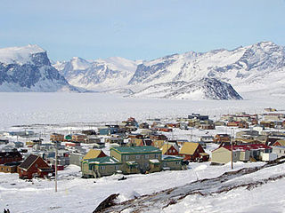
Pangnirtung is an Inuit hamlet, in the Qikiqtaaluk Region of the Canadian territory of Nunavut, located on Baffin Island. The community is located about 45 km (28 mi) south of the Arctic Circle, and about 2,700 km (1,700 mi) from the North Pole. Pangnirtung is situated on a coastal plain at the coast of Pangnirtung Fjord, a fjord which eventually merges with Cumberland Sound. As of January 2022, the mayor is Stevie Komoartok.
Inuvialuktun comprises several Inuit language varieties spoken in the northern Northwest Territories by Canadian Inuit who call themselves Inuvialuit. Some dialects and sub-dialects are also spoken in Nunavut.

Southampton Island is a large island at the entrance to Hudson Bay at Foxe Basin. One of the larger members of the Arctic Archipelago, Southampton Island is part of the Kivalliq Region in Nunavut, Canada. The area of the island is stated as 41,214 km2 (15,913 sq mi) by Statistics Canada. It is the 34th largest island in the world and Canada's ninth largest island. The only settlement on Southampton Island is Coral Harbour, called Salliq in Inuktitut.
The Inuvialuit or Western Canadian Inuit are Inuit who live in the western Canadian Arctic region. They, like all other Inuit, are descendants of the Thule who migrated eastward from Alaska. Their homeland – the Inuvialuit Settlement Region – covers the Arctic Ocean coastline area from the Alaskan border, east through the Beaufort Sea and beyond the Amundsen Gulf which includes some of the western Canadian Arctic Islands, as well as the inland community of Aklavik and part of Yukon. The land was demarked in 1984 by the Inuvialuit Final Agreement.

Helen Mamayaok Maksagak, was a Canadian politician. She served as the commissioner of the Northwest Territories from January 16, 1995, until March 26, 1999, and as the first commissioner of Nunavut from April 1, 1999, until April 1, 2000. She is a notable Copper Inuk. Born on the land near Bernard Harbour in the Canadian Western Arctic, Maksagak was raised in Tuktoyaktuk, Aklavik and the Bathurst Inlet area and eventually settled in Cambridge Bay to raise a family of six surviving children with her husband John Sr. Together they were stalwart supporters of the growing indigenous rights movement in the Canadian north. Their home was often a stopping place and site of discussions when young Inuit involved in negotiating the Nunavut Land Claims Agreement or participating in Northwest Territories political life passed through the community.

Cambridge Bay is a hamlet located on Victoria Island in the Kitikmeot Region of Nunavut, Canada. It is the largest settlement on Victoria Island. Cambridge Bay is named for Prince Adolphus, Duke of Cambridge, while the traditional Inuinnaqtun name for the area is Ikaluktutiak or Iqaluktuuttiaq meaning "good fishing place".
Baker Lake is a hamlet in the Kivalliq Region, in Nunavut on mainland Canada. Located 320 km (200 mi) inland from Hudson Bay, it is near the nation's geographical centre, and is notable for being Nunavut's sole inland community. The hamlet is located at the mouth of the Thelon River on the shore of Baker Lake. The community was given its English name in 1761 from Captain William Christopher who named it after Sir William Baker, the 11th Governor of the Hudson's Bay Company.

Gjoa Haven is an Inuit hamlet in Nunavut, above the Arctic Circle, located in the Kitikmeot Region, 1,056 km (656 mi) northeast of Yellowknife, Northwest Territories. It is the only settlement on King William Island.
The Indigenous peoples in Northern Canada consist of the First Nations, Métis, and Inuit located in Canada's three territories: Northwest Territories, Nunavut, and Yukon.
Maud, named for Queen Maud of Norway, was a ship built for Roald Amundsen for his second expedition to the Arctic. Designed for his intended voyage through the Northeast Passage, the vessel was built in Asker, a suburb of the capital, Oslo.
Abraham "Abe" Okpik, CM was an Inuit community leader in Canada. He was instrumental in helping Inuit obtain surnames rather than disc numbers as a form of government identification. He was also the first Inuk to sit on what is now the Legislative Assembly of the Northwest Territories and worked with Thomas Berger.

Cape Fullerton is a cape and peninsula in the Kivalliq Region of Nunavut, Canada located on the northwest shores of Hudson Bay on Roes Welcome Sound and includes Fullerton Harbour. Today it is part of Ukkusiksalik National Park. Although Cape Fullerton was traditionally home to migrant Inuit including the Aivilingmiut and the Qaernermiut, today the nearest permanently populated settlement is Chesterfield Inlet, roughly 100 km (62 mi) to the southwest.

The Bell Peninsula is located on southeastern Southampton Island, in the Kivalliq Region, Nunavut, Canada. It is in close proximity to the small Inuit community of Coral Harbour. The southern shores make up the northern boundary of Hudson Bay. Foxe Basin is to the east. There are several large bays surrounding the peninsula. Bowhead whale frequent the area. The Bell Peninsula's irregular coastline is marked by five distinct points, some of which have notable archaeological sites. Mount Minto, in the north, is the highest peak. The Back Peninsula is on the eastern end of the Bell Peninsula.
The Kugaryuak River is located in the Canadian Arctic territory of Nunavut in the southwest Kitikmeot Region. It forks into two entities, the Western Kugaryuak and the Eastern Kugaryuak and flows into Coronation Gulf.

Dorset Island or Cape Dorset Island is one of the Canadian Arctic islands located in Hudson Strait, Nunavut, Canada. It lies off the Foxe Peninsula area of southwestern Baffin Island in the Qikiqtaaluk Region. It is serviced by an airport and a harbour.

The Inuvialuit Settlement Region, abbreviated as ISR, located in Canada's western Arctic, was designated in 1984 in the Inuvialuit Final Agreement by the Government of Canada for the Inuvialuit people. It spans 90,650 km2 (35,000 sq mi) of land, mostly above the tree line, and includes several subregions: the Beaufort Sea, the Mackenzie River delta, the northern portion of Yukon, and the northwest portion of the Northwest Territories. The ISR includes both Crown Lands and Inuvialuit Private Lands.
Marble Island is one of several uninhabited Canadian arctic islands in Nunavut, Canada, located within western Hudson Bay. The closest community is Rankin Inlet. In the nineteenth century, the island was valued as a harbour for overwintering.

Dundas Harbour is an abandoned settlement in the Qikiqtaaluk Region, Nunavut, Canada. It is located on Devon Island at the eastern shore of the waterway also named Dundas Harbour. Baffin Bay's Croker Bay is immediately to the west.

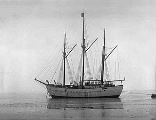
Aklavik was a small cargo vessel the Hudson's Bay Company used to carry supplies to, and furs from, its outposts in the high Arctic. She was active in the first half of the 20th century.
