The sea formed upon separation of the North American Plate and Greenland Plate that started about 60 million years ago and stopped about 40 million years ago. It contains one of the world's largest turbidity current channel systems, the Northwest Atlantic Mid-Ocean Channel (NAMOC), that runs for thousands of kilometres along the sea bottom toward the Atlantic Ocean.
The Labrador Sea is a major source of the North Atlantic Deep Water, a cold water mass that flows at great depth along the western edge of the North Atlantic.
Map showing the Labrador Sea according to the IHO definition
Between about 500 BC and 1300 AD, the southern coast of the sea contained Dorset, Beothuk, and Inuit settlements; Dorset tribes were later replaced by Thule people.[6]
Extent
Map all coordinates usingOpenStreetMapDownload coordinates asKML
Natural Resources Canada uses a slightly different definition, putting the northern boundary of the Labrador Sea on a straight line from a headland on Killiniq Island abutting Lady Job Harbour to Cape Farewell.[8]
Oceanography
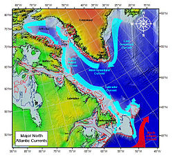
Major North Atlantic currents
The Labrador Sea is about 3,400m (1,859 fathoms; 11,155 feet) deep and 1,000km (621 miles; 540 nautical miles) wide where it joins the Atlantic Ocean. It becomes shallower, to less than 700m (383 fathoms; 2,297ft) towards Baffin Bay (see depth map) and passes into the 300km (190mi; 160nmi) wide Davis Strait.[2] A 100–200m (55–109 fathoms; 330–660ft) deep turbidity current channel system, which is about 2–5km (1.2–3.1mi; 1.1–2.7nmi) wide and 3,800km (2,400mi; 2,100nmi) long, runs on the bottom of the sea, near its center from the Hudson Strait into the Atlantic.[9][10] It is called the Northwest Atlantic Mid-Ocean Channel (NAMOC) and is one of the world's longest drainage systems of Pleistocene age.[11] It appears as a submarine river bed with numerous tributaries and is maintained by high-density turbidity currents flowing within the levees.[12]
The water temperature varies between −1°C (30°F) in winter and 5–6°C (41–43°F) in summer. The salinity is relatively low, at 31–34.9 parts per thousand. Two-thirds of the sea is covered in ice in winter. Tides are semi-diurnal (i.e. occur twice a day), reaching 4m (2.2 fathoms; 13ft).[1]
There is an anticlockwise water circulation in the sea. It is initiated by the East Greenland Current and continued by the West Greenland Current, which brings warmer, more saline waters northwards, along the Greenland coasts up to the Baffin Bay. Then, the Baffin Island Current and Labrador Current transport cold and less saline water southward along the Canadian coast. These currents carry numerous icebergs and therefore hinder navigation and exploration of the gas fields beneath the sea bed.[3][13] The speed of the Labrador current is typically 0.3–0.5m/s (0.98–1.64ft/s), but can reach 1m/s (3.3ft/s) in some areas,[14] whereas the Baffin Current is somewhat slower at about 0.2m/s (0.66ft/s).[15] The Labrador Current maintains the water temperature at 0°C (32°F) and salinity between 30 and 34 parts per thousand.[16]
The sea provides a significant part of the North Atlantic Deep Water (NADW) — a cold water mass that flows at great depth along the western edge of the North Atlantic, spreading out to form the largest identifiable water mass in the World Ocean.[17] The NADW consists of three parts of different origin and salinity, and the top one, the Labrador Sea Water (LSW), is formed in the Labrador Sea. This part occurs at a medium depth and has a relatively low salinity (34.84–34.89 parts per thousand), low temperature (3.3–3.4°C (37.9–38.1°F)) and high oxygen content compared to the layers above and below it. LSW also has a relatively low vorticity, i.e. the tendency to form vortices, than any other water in North Atlantic that reflects its high homogeneity. It has a potential density of 27.76–27.78mg/cm3 relatively to the surface layers, meaning it is denser, and thus sinks under the surface and remains homogeneous and unaffected by the surface fluctuations.[18]
The sea is also a feeding-ground for Atlantic salmon. Shrimp fisheries began in 1978, intensifying by 2000, in addition to cod fishing. However, by the 1990s, the cod fishing had already depleted the fishes' population near the Labrador and West Greenland banks, and was therefore halted in 1992.[13] Other fishery targets include haddock, Atlantic herring, lobster, several species of flatfish, and pelagic fish, such as sand lance and capelin. They are most abundant in the southern parts of the sea.[23]
↑Reinhard Hesse And Allan Rakofsky (1992). "Deep-Sea Channel/Submarine-Yazoo System of the Labrador Sea: A New Deep-Water Facies Model (1)". AAPG Bulletin. 76. doi:10.1306/BDFF88A8-1718-11D7-8645000102C1865D.
12Kenneth F. Drinkwater, R. Allyn Clarke. "Labrador Sea". The Canadian Encyclopedia. Archived from the original on 2 August 2018. Retrieved 3 February 2008.
This page is based on this Wikipedia article Text is available under the CC BY-SA 4.0 license; additional terms may apply. Images, videos and audio are available under their respective licenses.