Labrador Current

Last updated
Map of Labrador Current LabradorCurrentus-coastguard.jpg
Map of Labrador Current

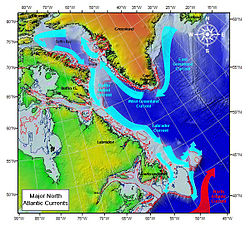
The Labrador Current is a cold current in the North Atlantic Ocean which flows from the Arctic Ocean south along the coast of Labrador and passes around Newfoundland, continuing south along the east coast of Canada near Nova Scotia. Near Nova Scotia, this cold water current meets the warm northward moving Gulf Stream. The combination of these two currents produces heavy fogs and has also created one of the richest fishing grounds in the world.

Contents

In spring and early summer, the Labrador Current transports icebergs from the glaciers of Greenland southwards into the trans-Atlantic shipping lanes. The waters of the current have a cooling effect on the Canadian Atlantic provinces, and on the United States' upper northeast coast from Maine south to Massachusetts. South of Cape Cod, Massachusetts, the Gulf Stream becomes the dominant ocean current.

Iceberg transport

Photo of eddies in the Labrador Current Labrador Current.jpg
Photo of eddies in the Labrador Current

The Labrador Current has a tendency to sometimes go farther south and/or east than normal. This can produce hazardous shipping conditions, for it can carry icebergs into an area of the Atlantic where they are not usually found. The current has been known to transport icebergs as far south as Bermuda and as far east as the Azores. After the sinking of the Titanic in 1912, the International Ice Patrol was set up to track icebergs, including those found in areas of the ocean where they are rarely located. [1]

Freshwater origins

The Labrador Current has an average annual velocity of 20 cm/s and is formed from very cold water that is around 1.5˚C from the Arctic through Baffin Island, Canada, and Western Greenland. These waters come together in the Labrador Sea. The Labrador Sea is affected by seasonality and will experience greater freshwater imports during the late spring and early summer with riverine runoff and glacial melt. [2]

The ocean circulation in the subpolar regions in the North Atlantic have seasonal variations due to the cold, freshwater Labrador Current and the warm, salty North Atlantic Current, as well as with changing surface winds, heat flux, and ice melting and formation. [3] There are two parts that make up the Labrador Current. The first part is baroclinic, meaning that the density depends on temperature and pressure, and is buoyancy-driven due to the amount of freshwater that is imported from the North. The second part of the Labrador Current is deeper and is barotropic, meaning the density is only dependent on pressure, and reaches a depth of about 2500 meters. [4]

The Baffin Bay and the Hudson Strait are the largest freshwater contributors in the Labrador Current. [5] The Hudson Strait is a narrow channel that is about 400 km long and is the opening to the Hudson Bay System, which is connected to the Labrador Sea, and contributes to 50% of the freshwater transport of the Labrador Current. The Hudson Bay is covered in ice in the winter and is ice-free in the summer. The Hudson Bay is made up of 42 rivers, contributing to the river runoff. The Labrador Current is made up of the Hudson Strait outflow, or the southeast flow, that meets with the Davis Strait and the West Greenland Current. [6] This current then flows south, down through Newfoundland and Flemish Cap and along the continental shelf break. Part of this current moves westward along the continental slope near Nova Scotia, eventually reaching north of the Gulf Stream, this is called the Slope Water Current. The southward flow joins in the subpolar circulation, forming the narrow, western subpolar gyre in the North Atlantic. The current interacts with the Gulf Stream and the North Atlantic Current forming the western boundary current that makes up this gyre. [7]

Related Research Articles

<span class="mw-page-title-main">Atlantic Ocean</span> Ocean between Europe, Africa and the Americas

The Atlantic Ocean is the second-largest of the world's five oceans, with an area of about 85,133,000 km2 (32,870,000 sq mi). It covers approximately 20% of Earth's surface and about 29% of its water surface area. It is known to separate the "Old World" of Africa, Europe, and Asia from the "New World" of the Americas in the European perception of the World.

<span class="mw-page-title-main">North Atlantic Current</span> Current of the Atlantic Ocean

The North Atlantic Current (NAC), also known as North Atlantic Drift and North Atlantic Sea Movement, is a powerful warm western boundary current within the Atlantic Ocean that extends the Gulf Stream northeastward.

<span class="mw-page-title-main">North Atlantic Deep Water</span> Deep water mass formed in the North Atlantic Ocean

North Atlantic Deep Water (NADW) is a deep water mass formed in the North Atlantic Ocean. Thermohaline circulation of the world's oceans involves the flow of warm surface waters from the southern hemisphere into the North Atlantic. Water flowing northward becomes modified through evaporation and mixing with other water masses, leading to increased salinity. When this water reaches the North Atlantic it cools and sinks through convection, due to its decreased temperature and increased salinity resulting in increased density. NADW is the outflow of this thick deep layer, which can be detected by its high salinity, high oxygen content, nutrient minima, high 14C/12C, and chlorofluorocarbons (CFCs).

<span class="mw-page-title-main">Hudson Strait</span> Strait connecting the Atlantic Ocean to Hudson Bay in Canada

The Hudson Strait links the Atlantic Ocean and the Labrador Sea to Hudson Bay in Canada. This strait lies between Baffin Island and Nunavik, with its eastern entrance marked by Cape Chidley in Newfoundland and Labrador and Resolution Island off Baffin Island. The strait is about 750 km long with an average width of 125 km, varying from 70 km at the eastern entrance to 240 km at Deception Bay.

<span class="mw-page-title-main">Ocean current</span> Directional mass flow of oceanic water generated by external or internal forces

An ocean current is a continuous, directed movement of seawater generated by a number of forces acting upon the water, including wind, the Coriolis effect, breaking waves, cabbeling, and temperature and salinity differences. Depth contours, shoreline configurations, and interactions with other currents influence a current's direction and strength. Ocean currents are primarily horizontal water movements.

<span class="mw-page-title-main">Thermohaline circulation</span> Part of large-scale ocean circulation

Thermohaline circulation (THC) is a part of the large-scale ocean circulation that is driven by global density gradients created by surface heat and freshwater fluxes. The adjective thermohaline derives from thermo- referring to temperature and -haline referring to salt content, factors which together determine the density of sea water. Wind-driven surface currents travel polewards from the equatorial Atlantic Ocean, cooling en route, and eventually sinking at high latitudes. This dense water then flows into the ocean basins. While the bulk of it upwells in the Southern Ocean, the oldest waters upwell in the North Pacific. Extensive mixing therefore takes place between the ocean basins, reducing differences between them and making the Earth's oceans a global system. The water in these circuits transport both energy and mass around the globe. As such, the state of the circulation has a large impact on the climate of the Earth.

<span class="mw-page-title-main">Baffin Bay</span> Marginal sea between Greenland and Baffin Island, Canada

Baffin Bay, located between Baffin Island and the west coast of Greenland, is defined by the International Hydrographic Organization as a marginal sea of the Arctic Ocean. It is sometimes considered a sea of the North Atlantic Ocean. It is connected to the Atlantic via Davis Strait and the Labrador Sea. The narrower Nares Strait connects Baffin Bay with the Arctic Ocean. The bay is not navigable most of the year because of the ice cover and high density of floating ice and icebergs in the open areas. However, a polynya of about 80,000 km2 (31,000 sq mi), known as the North Water, opens in summer on the north near Smith Sound. Most of the aquatic life of the bay is concentrated near that region.

<span class="mw-page-title-main">Labrador Sea</span> Arm of the North Atlantic Ocean between the Labrador Peninsula and Greenland

The Labrador Sea is an arm of the North Atlantic Ocean between the Labrador Peninsula and Greenland. The sea is flanked by continental shelves to the southwest, northwest, and northeast. It connects to the north with Baffin Bay through the Davis Strait. It is a marginal sea of the Atlantic.

<span class="mw-page-title-main">Ocean gyre</span> Any large system of circulating ocean surface currents

In oceanography, a gyre is any large system of circulating ocean surface currents, particularly those involved with large wind movements. Gyres are caused by the Coriolis effect; planetary vorticity, horizontal friction and vertical friction determine the circulatory patterns from the wind stress curl (torque).

<span class="mw-page-title-main">East Greenland Current</span> Current from Fram Strait to Cape Farewell off the eastern coat of Greenland

The East Greenland Current (EGC) is a cold, low-salinity current that extends from Fram Strait (~80N) to Cape Farewell (~60N). The current is located off the eastern coast of Greenland along the Greenland continental margin. The current cuts through the Nordic Seas and through the Denmark Strait. The current is of major importance because it directly connects the Arctic to the Northern Atlantic, it is a major contributor to sea ice export out of the Arctic, and it is a major freshwater sink for the Arctic.

<span class="mw-page-title-main">Laurentide Ice Sheet</span> Continental glacier in North America during the last ice age

The Laurentide Ice Sheet was a massive sheet of ice that covered millions of square miles, including most of Canada and a large portion of the Northern United States, multiple times during the Quaternary glacial epochs, from 2.58 million years ago to the present.

<span class="mw-page-title-main">Nares Strait</span> Canadian/Danish strait

Nares Strait is a waterway between Ellesmere Island and Greenland that connects the northern part of Baffin Bay in the Atlantic Ocean with the Lincoln Sea in the Arctic Ocean. From south to north, the strait includes Smith Sound, Kane Basin, Kennedy Channel, Hall Basin and Robeson Channel. Nares Strait has a nearly permanent current from the north, powered by the Beaufort Gyre, making it harder to traverse for ships coming from the south.

<span class="mw-page-title-main">West Greenland Current</span> Weak cold water current that flows to the north along the west coast of Greenland

The West Greenland Current is a weak cold water current that flows to the north along the west coast of Greenland. The current results from the movement of water flowing around the southernmost point of Greenland caused by the East Greenland Current.

<span class="mw-page-title-main">Atlantic meridional overturning circulation</span> System of surface and deep currents in the Atlantic Ocean

The Atlantic meridional overturning circulation (AMOC) is part of a global thermohaline circulation in the oceans and is the zonally integrated component of surface and deep currents in the Atlantic Ocean. It is characterized by a northward flow of warm, salty water in the upper layers of the Atlantic, and a southward flow of colder, deep waters. These "limbs" are linked by regions of overturning in the Nordic and Labrador Seas and the Southern Ocean, although the extent of overturning in the Labrador Sea is disputed. The AMOC is an important component of the Earth's climate system, and is a result of both atmospheric and thermohaline drivers.

<span class="mw-page-title-main">Northwest Atlantic Marine Ecozone</span> Canadian marine ecozone

The Northwest Atlantic Marine Ecozone, as defined by the Commission for Environmental Cooperation (CEC), is a Canadian marine ecozone forming a transitional region between the cold northern waters of the Arctic Ocean and the more temperate waters in its southern extent.

The following outline is provided as an overview of and introduction to Oceanography.

<span class="mw-page-title-main">Arctic Ocean</span> Ocean in the north polar region

The Arctic Ocean is the smallest and shallowest of the world's five major oceans. It spans an area of approximately 14,060,000 km2 (5,430,000 sq mi) and is known as one of the coldest of oceans. The International Hydrographic Organization (IHO) recognizes it as an ocean, although some oceanographers call it the Arctic Mediterranean Sea. It has also been described as an estuary of the Atlantic Ocean. It is also seen as the northernmost part of the all-encompassing World Ocean.

The Great Salinity Anomaly (GSA) originally referred to an event in the late 1960s to early 1970s where a large influx of freshwater from the Arctic Ocean led to a salinity anomaly in the northern North Atlantic Ocean, which affected the Atlantic meridional overturning circulation. Since then, the term "Great Salinity Anomaly" has been applied to successive occurrences of the same phenomenon, including the Great Salinity Anomaly of the 1980s and the Great Salinity Anomaly of the 1990s. The Great Salinity Anomalies were advective events, propagating to different sea basins and areas of the North Atlantic, and is on the decadal-scale for the anomalies in the 1970s, 1980s, and 1990s.

<span class="mw-page-title-main">Labrador Sea Water</span> Water mass formed by convective processes in the Labrador Sea

Labrador Sea Water is an intermediate water mass characterized by cold water, relatively low salinity compared to other intermediate water masses, and high concentrations of both oxygen and anthropogenic tracers. It is formed by convective processes in the Labrador Sea located between Greenland and the northeast coast of the Labrador Peninsula. Deep convection in the Labrador Sea allows colder water to sink forming this water mass, which is a contributor to the upper layer of North Atlantic Deep Water. North Atlantic Deep Water flowing southward is integral to the Atlantic Meridional Overturning Circulation. The Labrador Sea experiences a net heat loss to the atmosphere annually.

<span class="mw-page-title-main">Canadian Arctic Rift System</span> North American geological structure

The Canadian Arctic Rift System is a major North American geological structure extending from the Labrador Sea in the southeast through Davis Strait, Baffin Bay and the Arctic Archipelago in the northwest. It consists of a series of interconnected rifts that formed during the Paleozoic, Mesozoic and Cenozoic eras. Extensional stresses along the entire length of the rift system have resulted in a variety of tectonic features, including grabens, half-grabens, basins and faults.

References

  1. "Forefront of Evidence-Based Disaster Management". Suburban Emergency Management Project. Archived from the original on 2009-10-07. Retrieved 2010-01-05. The "Meandering Labrador Current" paragraph
  2. Li, Gang; Piper, David J. W. (2015-01-01). "The influence of meltwater on the Labrador Current in Heinrich event 1 and the Younger Dryas". Quaternary Science Reviews. 107: 129–137. Bibcode:2015QSRv..107..129L. doi:10.1016/j.quascirev.2014.10.021. ISSN   0277-3791.
  3. Han, Guoqi; Lu, Zhaoshi; Wang, Zeliang; Helbig, James; Chen, Nancy; de Young, Brad (2008-10-17). "Seasonal variability of the Labrador Current and shelf circulation off Newfoundland". Journal of Geophysical Research. 113 (C10): C10013. Bibcode:2008JGRC..11310013H. doi:10.1029/2007JC004376. ISSN   0148-0227.
  4. Thorpe, Steve A. (2009). Ocean Currents (2nd ed.). Elsevier. ISBN   978-0-08-096486-7.
  5. Mertz, G.; Narayanan, S.; Helbig, J. (1993). "The freshwater transport of the labrador current". Atmosphere-Ocean. 31 (2): 281–295. doi: 10.1080/07055900.1993.9649472 . ISSN   0705-5900.
  6. Straneo, Fiammetta; Saucier, François (2008-08-01). "The outflow from Hudson Strait and its contribution to the Labrador Current". Deep Sea Research Part I: Oceanographic Research Papers. 55 (8): 926–946. Bibcode:2008DSRI...55..926S. doi:10.1016/j.dsr.2008.03.012. hdl: 1912/2424 . ISSN   0967-0637. S2CID   129009304.
  7. Talley, Pickard, Emery, Swift, Lynne D., George L., William J., James H. (2011). Descriptive Physical Oceanography: An Introduction (6th ed.). Elsevier. ISBN   978-0-7506-4552-2.{{cite book}}: CS1 maint: multiple names: authors list (link)