An ocean current is a continuous, directed movement of seawater generated by a number of forces acting upon the water, including wind, the Coriolis effect, breaking waves, cabbeling, and temperature and salinity differences. Depth contours, shoreline configurations, and interactions with other currents influence a current's direction and strength. Ocean currents are primarily horizontal water movements.

Physical oceanography is the study of physical conditions and physical processes within the ocean, especially the motions and physical properties of ocean waters.

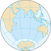
The Agulhas Current is the western boundary current of the southwest Indian Ocean. It flows south along the east coast of Africa from 27°S to 40°S. It is narrow, swift and strong. It is suggested that it is the largest western boundary current in the world ocean, with an estimated net transport of 70 sverdrups, as western boundary currents at comparable latitudes transport less — Brazil Current, Gulf Stream, Kuroshio.

The California Current is a cold water Pacific Ocean current that moves southward along the western coast of North America, beginning off southern British Columbia and ending off southern Baja California Sur. It is considered an Eastern boundary current due to the influence of the North American coastline on its course. It is also one of five major coastal currents affiliated with strong upwelling zones, the others being the Humboldt Current, the Canary Current, the Benguela Current, and the Somali Current. The California Current is part of the North Pacific Gyre, a large swirling current that occupies the northern basin of the Pacific.
The East Madagascar Current is an oceanic flow feature near Madagascar. It flows southward from 20°S on the east side of Madagascar to the southern limit at Cape Saint Marie and subsequently feeds the Agulhas Current. Its flow is complicated by large cyclonic and anticyclonic eddies.
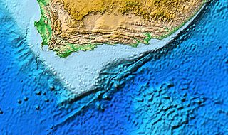
The Agulhas Bank is a broad, shallow part of the southern African continental shelf which extends up to 250 km (160 mi) south of Cape Agulhas before falling steeply to the abyssal plain.

A parent to the Florida Current, the Loop Current is a warm ocean current that flows northward between Cuba and the Yucatán Peninsula, moves north into the Gulf of Mexico, loops east and south before exiting to the east through the Florida Straits and joining the Gulf Stream. The Loop Current is an extension of the western boundary current of the North Atlantic subtropical gyre. Serving as the dominant circulation feature in the Eastern Gulf of Mexico, the Loop Currents transports between 23 and 27 sverdrups and reaches maximum flow speeds of from 1.5 to 1.8 meters/second.
The Madagascar current is an oceanic current in the west Indian Ocean.

Intense Tropical Cyclone Jokwe was the first tropical cyclone to make landfall in Mozambique since Cyclone Favio struck in the previous year, and was the most recent cyclone to make landfall on Mozambique until Cyclone Dineo in 2017. The tenth named storm of the 2007–08 South-West Indian Ocean cyclone season, Jokwe was first classified as a tropical depression on 2 March over the open Southwest Indian Ocean. It tracked west-southwest, crossing northern Madagascar as a tropical storm on 5 March before intensifying into a tropical cyclone on 6 March. Jokwe rapidly intensified to reach peak winds of 195 km/h (121 mph), before weakening slightly and striking Nampula Province in northeastern Mozambique. It quickly weakened while paralleling the coastline, though the storm restrengthened as it turned southward in the Mozambique Channel. Late in its duration, it remained nearly stationary for several days, and steadily weakened due to wind shear before dissipating on 16 March.
The Walvis Ridge is an aseismic ocean ridge in the southern Atlantic Ocean. More than 3,000 km (1,900 mi) in length, it extends from the Mid-Atlantic Ridge, near Tristan da Cunha and the Gough Islands, to the African coast. The Walvis Ridge is one of few examples of a hotspot seamount chain that links a flood basalt province to an active hotspot. It is also considered one of the most important hotspot tracks because the Tristan Hotspot is one of few primary or deep mantle hotspots.
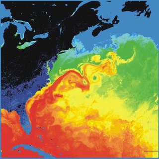
The Gulf Stream, together with its northern extension the North Atlantic Drift, is a warm and swift Atlantic ocean current that originates in the Gulf of Mexico and flows through the Straits of Florida and up the eastern coastline of the United States, then veers east near 36°N latitude and moves toward Northwest Europe as the North Atlantic Current. The process of western intensification causes the Gulf Stream to be a northward-accelerating current off the east coast of North America. Around 40°0′N30°0′W, it splits in two, with the northern stream, the North Atlantic Drift, crossing to Northern Europe and the southern stream, the Canary Current, recirculating off West Africa.
Retroflection is the movement of an ocean current that doubles back on itself.

The Agulhas Return Current (ARC) is an ocean current in the South Indian Ocean. The ARC contributes to the water exchange between oceans by forming a link between the South Atlantic Current and the South Indian Ocean Current. It can reach velocities of up to 4 knots and is therefore popular among participants in trans-oceanic sailing races.
Whaling in Madagascar is currently banned on a commercial level in compliance with sanctuary regulations. Despite erratic weather conditions, there is a history of overhunting sperm whales, humpback whales, and Bryde's whales within the surrounding waters of Madagascar. In an attempt to allow native populations to recuperate from these operations, the region about Madagascar was included within the Indian Ocean Whale Sanctuary by the International Whaling Commission.

The Agulhas Basin is an oceanic basin located south of South Africa where the South Atlantic Ocean and south-western Indian Ocean meet. Part of the African Plate, it is bounded by the Agulhas Ridge to the north and the Southwest Indian Ridge to the south; by the Meteor Rise to the west and the Agulhas Plateau to the east. Numerous bathymetric anomalies hint at the basin's dynamic tectonic history.
The North Madagascar Current is an ocean current near Madagascar. The Madagascar current is split into two currents: the North Madagascar Current and the East Madagascar Current (EMC). The North Madagascar Current (NMC) flows into the South Equatorial Current just north of Madagascar and is directed into the Mozambique Channel, this connects to the gyre's equatorial currents into the Agulhas Current off the coast of Southeastern Africa.
The Southwest Madagascar Coastal Current (SMACC) is a warm poleward ocean current flowing in the south-west of Madagascar.
Ring shedding is a phenomenon in ocean currents where circle or ring-shaped eddies separate from the current. The rings are independent water current systems that can persist for several months and occur in most ocean basins. The separated rings can have both warm or cold cores and play a role in the thermohaline circulation, interocean mixing, and nutrient supply for algae and bacteria. The physical processes behind ring shedding are not fully understood yet and are thus an active subject of research.
The Agulhas Leakage is an inflow of anomalously warm and saline water from the Indian Ocean into the South Atlantic due to the limited latitudinal extent of the African continent compared to the southern extension of the subtropical super gyre in the Indian Ocean. The process occurs during the retroflection of the Agulhas Current via shedding of anticyclonic Agulhas Rings, cyclonic eddies and direct inflow. The leakage contributes to the Atlantic Meridional Overturning Circulation (AMOC) by supplying its upper limb, which has direct climate implications.

Irminger Rings (IRs) are mesoscale ocean eddies that are formed off the West coast of Greenland and travel southwestwards through the Labrador Sea. Most IRs are anti-cyclonic. There is considerable interest in researching IRs, because they have been hypothesized to influence deep convection in the Labrador sea, and therefore the formation of deep water.