Leeuwin Current

Last updated
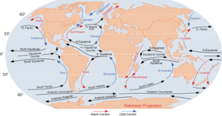
Ocean currents surrounding Australia. The Leeuwin Current can be seen off the Western Australian Coast. Australian ocean currents.png
Ocean currents surrounding Australia. The Leeuwin Current can be seen off the Western Australian Coast.
CSIRO NOAA polar orbiting satellites obtain the data generating sea surface temperature images. (Composite 15-day image showing the extension of the Leeuwin Current around Tasmania) CSIRO ScienceImage 10719 NOAA polar orbiting satellites obtain the data generating sea surface temperature images This is a composite 15day image showing the extension of the Leeuwin Current around Tasmania.jpg
CSIRO NOAA polar orbiting satellites obtain the data generating sea surface temperature images. (Composite 15-day image showing the extension of the Leeuwin Current around Tasmania)

The Leeuwin Current is a warm ocean current which flows southwards near the western coast of Australia. It rounds Cape Leeuwin to enter the waters south of Australia where its influence extends as far as Tasmania.

Contents

The West Australian Current and Southern Australian Countercurrent, which are produced by the West Wind Drift on the southern Indian Ocean and at Tasmania, respectively, flow in the opposite direction, producing one of the most interesting oceanic current systems in the world.

Its strength varies through the year; it is weakest during the summer months (winter in the northern hemisphere) from November to March when the winds tend to blow strongly from the south west northwards. The greatest flow is in the autumn and winter (March to November) when the opposing winds are weakest. Evaporation from the Leeuwin current during this period contributes greatly to the rainfall in the southwest region of Western Australia.

Typically the Leeuwin Current's speed and its eddies are about 1 knot (50 cm/s), although speeds of 2 knots (1 m/s) are common, and the highest speed ever recorded by a drifting satellite-tracked buoy was 3.5 knots (6.5 km/h). The Leeuwin Current is shallow for a major current system, by global standards, being about 300 m deep, and lies on top of a northwards countercurrent called the Leeuwin Undercurrent.

The Leeuwin Current is very different from the cooler, equatorward flowing currents found along coasts at equivalent latitudes such as the southwest African Coast (the Benguela Current); the long Chile-Peru Coast (the Humboldt Current), where upwelling of cool nutrient-rich waters from below the surface results in some of the most productive fisheries; the California Current, which brings foggy conditions to San Francisco; or the cool Canary current of North Africa.

Because of the Leeuwin Current, the continental shelf waters of Western Australia are warmer in winter and cooler in summer than the corresponding regions off the other continents. The Leeuwin Current is also responsible for the presence of the most southerly true corals at the Abrolhos Islands and the transport of tropical marine species down the west coast and across into the Great Australian Bight.
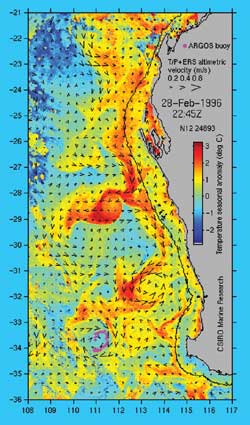
Data from two satellite instruments is used in constructing this image of the Leeuwin Current. Sea surface temperature information comes from the US NOAA 14 satellite while the surface current velocity is derived from sea level measurements made by the satellite-borne altimeter. Sea level data from the US/French Topex/Poseidon and European ERS altimeters are combined Leeuwin current 2.jpg
Data from two satellite instruments is used in constructing this image of the Leeuwin Current. Sea surface temperature information comes from the US NOAA 14 satellite while the surface current velocity is derived from sea level measurements made by the satellite-borne altimeter. Sea level data from the US/French Topex/Poseidon and European ERS altimeters are combined

The ‘core’ of the Leeuwin Current can generally be detected as a peak in the surface temperature with a strong temperature decrease further offshore. The surface temperature difference across the Current is about 1 °C at North West Cape, 2° to 3° at Fremantle and can be over 4° off Albany in the Great Australian Bight. The current frequently breaks out to sea, forming both clockwise and anti-clockwise eddies.

The Leeuwin Current is influenced by El Niño conditions, characterised by slightly lower sea temperatures along the Western Australian coast and a weaker Leeuwin Current, with corresponding effects upon rainfall patterns.

The existence of the current was first suggested by William Saville-Kent in 1897. Saville-Kent noted the presence of warm tropical water offshore in the Houtman Abrolhos, making the water there in winter much warmer than inshore at the adjacent coast. The existence of the current was confirmed over the years, but not characterised and named until Cresswell and Golding did so in the 1980s. [1]

See also

Related Research Articles

Houtman Abrolhos Group of islands and reefs off Western Australia

The Houtman Abrolhos is a chain of 122 islands, and associated coral reefs, in the Indian Ocean off the west coast of Australia, about eighty kilometres (50 mi) west of Geraldton, Western Australia. It is the southernmost true coral reef in the Indian Ocean, and one of the highest latitude reef systems in the world. It is one of the world's most important seabird breeding sites, and is the centre of Western Australia's largest single-species fishery, the western rock lobster fishery. It has a small seasonal population of fishermen, and a limited number of tourists are permitted for day trips, but most of the land area is off limits as conservation habitat. It is well known as the site of numerous shipwrecks, the most famous being the Dutch ships Batavia, which was wrecked in 1629, and Zeewijk, wrecked in 1727.

Great Australian Bight Open bay off southern Australia

The Great Australian Bight is a large oceanic bight, or open bay, off the central and western portions of the southern coastline of mainland Australia.

Ocean current Directional mass flow of oceanic water generated by external or internal forces

An ocean current is a continuous, directed movement of sea water generated by a number of forces acting upon the water, including wind, the Coriolis effect, breaking waves, cabbeling, and temperature and salinity differences. Depth contours, shoreline configurations, and interactions with other currents influence a current's direction and strength. Ocean currents are primarily horizontal water movements.

California Current Pacific Ocean current that flows southward along the western coast of North America from southern British Columbia to the southern Baja California Peninsula

The California Current is a cold water Pacific Ocean current that moves southward along the western coast of North America, beginning off southern British Columbia and ending off southern Baja California Sur. It is considered an Eastern boundary current due to the influence of the North American coastline on its course. It is also one of five major coastal currents affiliated with strong upwelling zones, the others being the Humboldt Current, the Canary Current, the Benguela Current, and the Somali Current. The California Current is part of the North Pacific Gyre, a large swirling current that occupies the northern basin of the Pacific.

<i>Panulirus cygnus</i> Species of crustacean

Panulirus cygnus is a species of spiny lobster, found off the west coast of Australia. Panulirus cygnus is the basis of Australia's most valuable fishery, making up 20% of value of Australia's total fishing industry, and is identified as the western rock lobster.

North Island (Houtman Abrolhos) Island in the Houtman Abrolhos, off the coast of Mid West Western Australia

North Island is the northernmost island in the Houtman Abrolhos, a coral reef archipelago in the Indian Ocean off the coast of Mid West Western Australia. Located about 14 km (9 mi) from the nearest island group, it is one of the largest islands in the Houtman Abrolhos, and one of the few to support dune systems. It has relatively diverse flora dominated by chenopod shrubs and fauna that includes the introduced tammar wallaby, around seven species of reptile, and about 15 resident bird species.

<i>Batavia Road</i> (boat)

Batavia Road was a passenger boat used from 1946 for commercial tourist operation in the Houtman Abrolhos, a group of islands off the coast of Western Australia.

Coastal regions of Western Australia

Western Australia has the longest coastline of any state or territory in Australia, at 10,194 km or 12,889 km. It is a significant portion of the coastline of Australia, which is 35,877 km.

The south coast of Western Australia comprises the Western Australian coastline from Cape Leeuwin to Eucla. This is a distance of approximately 1,600 kilometres (1,000 mi), fronting the Great Australian Bight and the Southern Ocean.

The Seagrasses of Western Australia are submerged flowering plants found along the coast, around islands, and in Estuaries of Western Australia. The region contains some of the largest seagrass meadows in the world, and is the most diverse in the number of species. The variety of habitats along its western and southern coasts is often soft sands in shallow subtropical waters, ideal for these plants.

Southern Ocean Ocean around Antarctica

The Southern Ocean, also known as the Antarctic Ocean, comprises the southernmost waters of the World Ocean, generally taken to be south of 60° S latitude and encircling Antarctica. As such, it is regarded as the second-smallest of the five principal oceanic divisions: smaller than the Pacific, Atlantic, and Indian oceans but larger than the Arctic Ocean. Over the past 30 years, the Southern Ocean has been subject to rapid climate change, which has led to changes in the marine ecosystem.

Jurien Bay Marine Park Protected area in Western Australia

The Jurien Bay Marine Park is a protected marine park that is located 200 to 300 kilometres north of Perth, off the coastal tip of the Wheatbelt region of Western Australia. The 82,375-hectare (203,550-acre) marine park was formally declared on 31 August 2003 and is situated along the Indian Ocean Drive that extends south from Green Head to the southern boundary of Nambung National Park. It includes many of the islands located in this region.

Hypothalassia acerba is a large crab found in the muddy substrates of the deep seas off the southwestern Australian and New Zealand coasts. Australian distribution, which is correlated to depth and temperature, ranges from a latitude as far north as approximately 27° S on the west coast, southwards, then eastwards on the south coast to a longitude of at least 129° E. The species usually occurs in waters with temperatures of 13–19 °C (55–66 °F) and in depths ranging of 200–255 metres (656–837 ft) on the lower west coast and 90–200 m (300–660 ft) on the south coast. Body size is inversely related to depth of water. There are only two species in the genus Hypothalassia, and H. acerba is not the same champagne crab as the other Hypothalassia species, H. armata, which is found in Japanese waters.

West Australian Current Cool surface current that starts as the Southern Indian Ocean Current and turns north when it approaches Western Australia

The West Australian Current, is a cool surface current of the Southern Ocean and Southern Indian Ocean.

References

  1. Pearce, A. F. (1997). "The Leeuwin Current and the Houtman Abrolhos Islands, Western Australia". In Wells, F. E. (ed.). The Marine Flora and Fauna of the Houtman Abrolhos Islands, Western Australia, Volume 1. Perth: Western Australian Museum. pp. 11–46.

Further reading