Ocean boundary current that flows along the coast of Somalia and Oman in the Western Indian Ocean
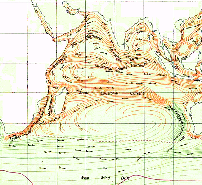
The Somali Current off the Somali coast in the context of the Indian Ocean Gyre during (northern) summer. The circular current east of the Horn of Africa is known as the Great Whirl
The Somali Current is a cold ocean boundary current that runs along the coast of Somalia and Oman in the Western Indian Ocean and is analogous to the Gulf Stream in the Atlantic Ocean.[1] This current is heavily influenced by the monsoons and is the only major upwelling system that occurs on a western boundary of an ocean. The water that is upwelled by the current merges with another upwelling system, creating one of the most productive ecosystems in the ocean.[2]
The Somali current is characterized by seasonal changes influenced by the Southwest monsoon and the Northeast Monsoon. During the months of June to September, the warm Southwest monsoon moves the coastal waters northeastward, creating coastal upwelling. The upwelled water is carried offshore by Ekman transport and merges with water that was brought to the surface by open-ocean upwelling. The Somali Jet, aka. the Findlater Jet, a narrow low-level, atmospheric jet, also develops during the Southwest monsoon, and blows diagonally across the Indian Ocean, parallel to the coasts of Somalia and Oman. As a result, an Ekman transport is created to the right of the wind. At the center of the jet, the transport is maximum and decreases to the right and left with increasing distance. To the left of the jet center, there is less water movement toward the center than is leaving, creating a divergence in the upper layer and resulting in an upwelling event (Ekman suction). In contrast, to the right of the center of the jet, more water is coming from the center than is leaving, creating a downwelling event (Ekman pumping). This open-ocean upwelling in combination with the coastal upwelling causes a massive upwelling.[1]
History
The history of physical oceanographic approaches to the Somali current has begun from the mid-1960s with serious interests. From the mid-1960s until the late 1970s several magnificent theoretical studies had been proposed and gave physical answers of the current behaviors and formations. After the late 1970s, the physics of the Somali current enhanced by ocean data analyses with outstanding field measurements of the current properties. The research footprints during the early 1960s to the late 1970s are presented as below.[3]
(early research histories before 1981)
1966 Warren et al.: Oceanographers and Meteorologists agreed the existence of the Somali current and its behaviors, but its exact processes and involved nature sources had not been clearly understood.[4]
1969 Lighthill: the source of the Somali current is mass flux deposited by baroclinic and barotropic waves in the western boundary region.[5]
1970 Düing: presented the presence of alternative cyclonic and anti-cyclonic gyre, the Indian Ocean Gyres. Found eddy size of the Indian Ocean Gyres are much larger than the gyres of the other mid-latitude western boundary currents (the Indian Ocean Gyres ~ 300-500 nmi > the Gulf Stream / Kuroshio ~ 50 – 100 nmi) [6]
1971 Düing & Szekelda: the baroclinic mode is the dominant mode of the Somali current [7]
1972,1973 Leetma: local winds are crucial to the onset of the Somali Current.[8][9]
1975 Colborn: climatological analysis of the entire Indian Ocean from bathythermograph and hydrocast observations [10]
1976 Hurlburt & Thompson: Characterize the Somali current as a time-dependent, baroclinic, inertial boundary current.[11]
1976 Bruce: time-series analyses, XBT cross-section measurement by the EXXON tankers [3]
1979 USNS WILKES: the Great Whirl (Prime Eddy) and the Socotra Eddy together with the strong shear zone along the eastern edge of the Great Whirl were observed during late August and early September 1979.[3]
Properties
The Somali Current is rapid response, shallow and shifts its direction seasonally. Especially from 5°N and southward, the Somali current is extremely shallow (under 150m depth southward flow all year through). Further north, the jet deepens somewhat, reaching the permanent thermocline. The structure of the current around the equator is extremely complex and similarly layered to the equatorial flows, though the Somali Current is oriented north-southward instead of east-westward.
The typical water volume transported by the Somali Current amounts to 37 ± 5 Sv (0.037 ± 5km3/s) during mid-September,[12] making the current circulation generally weaker than other mid-latitude western boundary currents (such as the Gulf Stream, the Kuroshio current). However, volume transport maxima as high as 60-70 Sv (comparable to the Gulf Stream) have been measured around the south of Socotra Island.[3]
Southward Somali Current during Northeast Indian Monsoon
The Somali Current reaches speeds of up to 7 knots during the summer months weakening and eventually reversing direction during the winter.
Formation and behavior
The Somali Current is driven principally by the seasonal monsoon winds. In (Northern) summer (May – September) the southwest monsoon blows along the east coast of Africa and Oman. During the fall it reverses its direction to become a northeasterly wind during (Northern) winter.
Before the onset of the monsoon (March–May): During this season, shallow northward coastal current flows with 50–100km width near the Somali coast, overlying a southward undercurrent. By alongshore winds, upwelling current flows to the coast. Near the equator, the East African Coast Current (EACC) flows northward across the equator. The southern Somali Current flows northward as an extension of the EACC from south to the 3-4°N.[13]
Northeastward current (Jun-Sep, Summer Monsoon): The Somali Current begins developing its strength from mid-May with the summer monsoon onset, and current velocities rapidly grow to the maximum until June and September with the southwest monsoon blowing. During this season, the current direction is northeastward, and the velocity in mid-May is about 2.0m/s and in June, 3.5m/s and more. Typically the Somali Current will move about 1500km to the northeast and, near Cape Guardafui[3] (at 6~10°N), change its direction to the east to merge with the Indian Monsoon current.[3][14]
According to the works of Friedrich A. Schott and Julian P. McCreary Jr., the Northeastward Somali current has the following two sub-season periods. During June–July, the Great Whirl grows at 4-10°N, and a cold wedge shape water mass develops to the offshore at latitude 10-12°N. The size and strength of the Great Whirl during the summer monsoon is measured as 10cm/s velocity at about 1000 m depth, while some visible gyre structure is observed at further depth. The upper layer Somali Current flows northwards along the East African coast, and finally enters the Gulf of Aden between the Socotra Archipelago and the Horn of Africa. The mean flow velocity of this outgoing current is about 5 Sv.
The period between August and September is the late phase of the summer monsoon. During this period, the Great Whirl almost forms a closed circulation, and strong upwelling streams (colder than 17°C, typical upwelling water temperature ~ 19-23°C) develop near the Northern Somali coast.[13]
After the summer monsoon recedes (Oct-Nov): During this period, the southwest monsoon winds continually weaken, so the Northward Somali Current (extension flow of the EACC) no longer crosses the equator, turning instead to the east at around 3°N. However, the Great Whirl still remains.[13]
Southwestward current (Dec-Feb, Winter Monsoon): During the fall (Sep-Nov), with the strengthening northeast monsoon influencing it, the Somali Current gradually becomes weaker and slower. Finally, in early December, beginning south of 5°N and expanding rapidly to 10°N by January, the current reverses its direction, now flowing southwardly (velocities of 0.7 – 1.0m/s). The Somali Current flows to the south throughout (Northern) Winter (Dec-Feb), constrained to the region south of 10°N, until in March, southward flow recedes again to 4°N to be reversed in April.[14]
During the winter monsoon, after crossing the equator, the southward Somali Current comes into confluence with the northward EACC and thereafter flows to the East.
Upwelling behavior: One of the unique characteristics of the Somali Current is the presence of strong coastal upwelling - the only major instance of this happening at a western ocean boundary. Following Ekman transport and with the southwest monsoon blowing parallel to the Somali coastline, the upwelling direction is to the offshore during the summer: The warm and salty Somali Current flows northward across the equator to turn to the East near Cape Guardafui. This flow deflection causes strong upwelling along the Somali coast, lowering coastal temperatures by 5°C or more from May through September.[14]
During the winter season, the northeast monsoon reverses the northward Somali Coastal Current, shutting down coastal upwelling.[15]
Somali Undercurrent: April – early June; A southward undercurrent develops underneath the northward surface current (depth 100-300m, monthly average velocity 20cm/s, maximum 60cm/s), stretching to the near 4°N and turning offshore. It is eventually terminated by the establishment of the deep–reaching Great Whirl. Fall – Winter; Similarly, a southward undercurrent develops underneath the northward surface current between 8 and 12°N.
Winter; A northward cross-equatorial undercurrent (depth 150-400m) flows underneath the southward surface Somali Current, with their flows balancing. Because of this undercurrent, near the equator, the surface (southward) Somali Current is extremely shallow (less than 150m).[13]
Great Whirl
Two gigantic eddies at the north west Indian Ocean during Southwest Monsoon
The Great Whirl is a huge anti-cyclonic eddy generated by the Somali current flowing in (northern) summer, and one of the two gigantic Indian Ocean Gyres (the other is the Socotra Gyre). The Great Whirl can be observed between 5-10°N and 52-57°E off the Somali coast in the summer season, a location typically around 200km southwest of the Socotra Gyre (between June and September).[13][16] However, in the past both the Great Whirl and the Socotra Gyre have been known to occasionally collapse, and their exact locations differ from year to year. The Great Whirl's typical size is 400–600km in horizontal diameter,[6] and typical surface current velocity is 1.5-2.0m/s.[17]
How the Great Whirl forms exactly isn't yet fully understood, but the analytical approach of applying Rossby wave theory can explain its basic formation mechanism. By observation and analysis of [Schott and Quadfasel (1982)], the summer monsoon develops suddenly during June–July, and drives westward water flow in the location. Schott and Quadfasel applied first-mode Rossby waves to the water flows, and concluded that "the formation of the Great Whirl is a response to the very strong anti-cyclonic wind-stress curl".[13]
Since the Somali current changes seasonally, the Great Whirl also displays seasonal behaviour in keeping with the monsoon cycle. The eddy is usually evident between June and September, however e.g. in 1995, the Somali Current did not develop in June at all, so that during that time the eddy was severely weakened and of very small size - a prolonged onset phase. As the Somali Current developed through the summer, it was only in September that the Great Whirl finally maximized and began to disperse, entering the winter season (the wane).[18][19] Conversely, the Great Whirl may also continue to exist until mid-October, still exhibiting large size and its curl structure may remain evident even longer, underneath the winter Somali Current.[13]
This seasonal behaviour of the Great Whirl affects the local coastal ocean flows and thus the Arabian Sea ecosystem: During the summer season, coastal upwelling currents strongly dependent on the shape and behaviour of the eddy are observed to the northwest of the Great Whirl. Not only does the biological productivity of the region depend on these upwelling currents, they (and thus, the Great Whirl itself) also play a large part in regulating the heat flux budget of the North Indian Ocean.[20]
Effect on marine ecosystem
Upwelling current at the Somali coast during Southwest Monsoon
The offshore Somali coastal area is one of the most productive marine ecosystems in the world. Especially during the southwest Indian monsoon, strong upwelling pumps cold (17-22°C) and highly nutrient rich (about 5 to 20 μm of nitrate [21]) subsurface water to the coastal region. During this season, mean phytoplankton density and productivity is further boosted by the activities of the offshore eddy, the Great Whirl.[22] Total zooplankton biomass consists of about 25% Euphausids, the rest being Copepods (dominant zooplankton species in the region ~ Calanoides carinatus and Eucalanus elongates).[22][23] However, the fast-moving Somali Current reduces the residence time of the upwelled nutrient-rich water, thus limiting biological productivity in this region somewhat.[24] A major part of this unutilized nutrient is transported to the southern Arabian Sea, supporting biological production there. Furthermore, the high wind speeds (approximately 15m/s) of the Southwest monsoon affecting the Somali Current induce intense vertical mixing, increasing the thickness of the mixed layer as well as overall surface nutrient enrichment leading to high productivity.[25] After this season, with the onset of the Northeast (Winter) Monsoon, primary productivity decreases, though zooplankton density does so only slightly.
Downwelling is the downward movement of a fluid parcel and its properties within a larger fluid. It is closely related to upwelling, the upward movement of fluid.
Upwelling is an oceanographic phenomenon that involves wind-driven motion of dense, cooler, and usually nutrient-rich water from deep water towards the ocean surface. It replaces the warmer and usually nutrient-depleted surface water. The nutrient-rich upwelled water stimulates the growth and reproduction of primary producers such as phytoplankton. The biomass of phytoplankton and the presence of cool water in those regions allow upwelling zones to be identified by cool sea surface temperatures (SST) and high concentrations of chlorophyll a.
An ocean current is a continuous, directed movement of seawater generated by a number of forces acting upon the water, including wind, the Coriolis effect, breaking waves, cabbeling, and temperature and salinity differences. Depth contours, shoreline configurations, and interactions with other currents influence a current's direction and strength. Ocean currents are primarily horizontal water movements.
The Cromwell Current is an eastward-flowing subsurface current that extends the length of the equator in the Pacific Ocean.
The Benguela Current is the broad, northward flowing ocean current that forms the eastern portion of the South Atlantic Ocean gyre. The current extends from roughly Cape Point in the south, to the position of the Angola-Benguela front in the north, at around 16°S. The current is driven by the prevailing south easterly trade winds. Inshore of the Benguela Current proper, the south easterly winds drive coastal upwelling, forming the Benguela Upwelling System. The cold, nutrient rich waters that upwell from around 200–300 m (656–984 ft) depth in turn fuel high rates of phytoplankton growth, and sustain the productive Benguela ecosystem.
In oceanography, a gyre is any large system of circulating ocean surface currents, particularly those involved with large wind movements. Gyres are caused by the Coriolis effect; planetary vorticity, horizontal friction and vertical friction determine the circulatory patterns from the wind stress curl (torque).
The Humboldt Current, also called the Peru Current, is a cold, low-salinity ocean current that flows north along the western coast of South America. It is an eastern boundary current flowing in the direction of the equator, and extends 500–1,000 km (310–620 mi) offshore. The Humboldt Current is named after the German naturalist Alexander von Humboldt even though it was discovered by José de Acosta 250 years before Humboldt. In 1846, von Humboldt reported measurements of the cold-water current in his book Cosmos.
The California Current is a cold water Pacific Ocean current that moves southward along the western coast of North America, beginning off southern British Columbia and ending off southern Baja California Sur. It is considered an Eastern boundary current due to the influence of the North American coastline on its course. It is also one of six major coastal currents affiliated with strong upwelling zones, the others being the Humboldt Current, the Canary Current, the Benguela Current, the Oyashio Current, and the Somali Current. The California Current is part of the North Pacific Gyre, a large swirling current that occupies the northern basin of the Pacific.
The East Australian Current (EAC) is a warm, southward, western boundary current that is formed from the South Equatorial Current (SEC) crossing the Coral Sea and reaching the eastern coast of Australia. At around 15° S near the Australian coast the SEC divides forming the southward flow of the EAC. It is the largest ocean current close to the shores of Australia.
The North Equatorial Current (NEC) is a westward wind-driven current mostly located near the equator, but the location varies from different oceans. The NEC in the Pacific and the Atlantic is about 5°-20°N, while the NEC in the Indian Ocean is very close to the equator. It ranges from the sea surface down to 400 m in the western Pacific.
The Equatorial Counter Current is an eastward flowing, wind-driven current which extends to depths of 100–150 metres (330–490 ft) in the Atlantic, Indian, and Pacific Oceans. More often called the North Equatorial Countercurrent (NECC), this current flows west-to-east at about 3-10°N in the Atlantic, Indian Ocean and Pacific basins, between the North Equatorial Current (NEC) and the South Equatorial Current (SEC). The NECC is not to be confused with the Equatorial Undercurrent (EUC) that flows eastward along the equator at depths around 200 metres (660 ft) in the western Pacific rising to 100 metres (330 ft) in the eastern Pacific.
The Alaska Current is a southwestern shallow warm-water current alongside the west coast of the North American continent beginning at about 48-50°N. The Alaska Current produces large clockwise eddies at two sites: west of the Haida Gwaii and west of Sitka, Alaska.
The North Pacific Gyre (NPG) or North Pacific Subtropical Gyre (NPSG), located in the northern Pacific Ocean, is one of the five major oceanic gyres. This gyre covers most of the northern Pacific Ocean. It is the largest ecosystem on Earth, located between the equator and 50° N latitude, and comprising 20 million square kilometers. The gyre has a clockwise circular pattern and is formed by four prevailing ocean currents: the North Pacific Current to the north, the California Current to the east, the North Equatorial Current to the south, and the Kuroshio Current to the west. It is the site of an unusually intense collection of human-created marine debris, known as the Great Pacific Garbage Patch.
Ekman transport is part of Ekman motion theory, first investigated in 1902 by Vagn Walfrid Ekman. Winds are the main source of energy for ocean circulation, and Ekman transport is a component of wind-driven ocean current. Ekman transport occurs when ocean surface waters are influenced by the friction force acting on them via the wind. As the wind blows it casts a friction force on the ocean surface that drags the upper 10-100m of the water column with it. However, due to the influence of the Coriolis effect, the ocean water moves at a 90° angle from the direction of the surface wind. The direction of transport is dependent on the hemisphere: in the northern hemisphere, transport occurs at 90° clockwise from wind direction, while in the southern hemisphere it occurs at 90° anticlockwise. This phenomenon was first noted by Fridtjof Nansen, who recorded that ice transport appeared to occur at an angle to the wind direction during his Arctic expedition of the 1890s. Ekman transport has significant impacts on the biogeochemical properties of the world's oceans. This is because it leads to upwelling and downwelling in order to obey mass conservation laws. Mass conservation, in reference to Ekman transfer, requires that any water displaced within an area must be replenished. This can be done by either Ekman suction or Ekman pumping depending on wind patterns.
In physical oceanography and fluid dynamics, the wind stress is the shear stress exerted by the wind on the surface of large bodies of water – such as oceans, seas, estuaries and lakes. When wind is blowing over a water surface, the wind applies a wind force on the water surface. The wind stress is the component of this wind force that is parallel to the surface per unit area. Also, the wind stress can be described as the flux of horizontal momentum applied by the wind on the water surface. The wind stress causes a deformation of the water body whereby wind waves are generated. Also, the wind stress drives ocean currents and is therefore an important driver of the large-scale ocean circulation. The wind stress is affected by the wind speed, the shape of the wind waves and the atmospheric stratification. It is one of the components of the air–sea interaction, with others being the atmospheric pressure on the water surface, as well as the exchange of energy and mass between the water and the atmosphere.
The Weddell Gyre is one of the two gyres that exist within the Southern Ocean. The gyre is formed by interactions between the Antarctic Circumpolar Current (ACC) and the Antarctic Continental Shelf. The gyre is located in the Weddell Sea, and rotates clockwise. South of the ACC and spreading northeast from the Antarctic Peninsula, the gyre is an extended large cyclone. Where the northeastern end ends at 30°E, which is marked by the southward turn of the ACC, the northern part of the gyre spreads over the Southern Scotia Sea and goes northward to the South Sandwich Arc. Axis of the gyre is over the southern flanks of the South Scotia, America-Antarctic, and Southwest Indian Ridges. In the southern part of the gyre, the westward return flow is about 66sverdrup(Sv), while in the northern rim current, there is an eastward flow of 61Sv.
The Indian Monsoon Current refers to the seasonally varying ocean current regime found in the tropical regions of the northern Indian Ocean. During winter, the flow of the upper ocean is directed westward from near the Indonesian Archipelago to the Arabian Sea. During the summer, the direction reverses, with eastward flow extending from Somalia into the Bay of Bengal. These variations are due to changes in the wind stress associated with the Indian monsoon. The seasonally reversing open ocean currents that pass south of India are referred to as the Winter Monsoon Current and the Summer Monsoon Current. The cold Somali Current, which is strongly linked to the Indian monsoon, is also discussed in this article.
The Mindanao Current (MC) is a southward current in the western Pacific Ocean that transports mass and freshwater between ocean basins. It is a low-latitude western boundary current that follows the eastern coast of the Philippine island group and its namesake, Mindanao. The MC forms from the North Equatorial Current (NEC) that flows from east to west between 10-20°N. As it travels west, the NEC reaches its western limit: the coast of the Philippines. Once it encounters shallower waters near land, it “splits” into two branches: one moves northward and becomes the Kuroshio current and one moves southward and becomes the Mindanao Current. The process of splitting is called a bifurcation.
A Wind generated current is a flow in a body of water that is generated by wind friction on its surface. Wind can generate surface currents on water bodies of any size. The depth and strength of the current depend on the wind strength and duration, and on friction and viscosity losses, but are limited to about 400 m depth by the mechanism, and to lesser depths where the water is shallower. The direction of flow is influenced by the Coriolis effect, and is offset to the right of the wind direction in the Northern Hemisphere, and to the left in the Southern Hemisphere. A wind current can induce secondary water flow in the form of upwelling and downwelling, geostrophic flow, and western boundary currents.
Low-latitude western boundary currents (LLWBC) are western boundary currents located between the subtropical gyres, within 20° of the equator. They are important for closing the tropical circulation driven by the equatorial zonal flow, and facilitate inter-ocean transport between the subtropical gyres. They occur in regions of negative (positive) wind stress curl in the southern (northern) hemisphere, and originate at the western bifurcation point of the South or North Equatorial Current. They are typically equatorward (cyclonic) as opposed to sub-tropical western boundary currents, which tend to be poleward (anticyclonic). Some well-known examples include the Mindanao Current (MC) and the East African Coastal Current (EACC).
↑ Mann, K.H., Lazier, J.R.N. (2006) "Dynamics of marine ecosystems: biological-physical interactions in the oceans." Oxford: Blackwell Publishing Ltd. ISBN1-4051-1118-6
1 2 3 4 5 6 Beatty III, William H.; John G. Bruce; Robert C. Guthrie (1981). "Circulation and Oceanographic Properties in the Somali Basin as observed during the 1979 southwest monsoon". Technical Report AD-A276 238.
1 2 Düing, W. (1970). The monsoon regime of the current in the Indian Ocean. Honolulu: University of Hawaii Press. p.68.
↑ Düing, W.; K.H.Szekielda (1971). "Monsoonal response in the western Indian Ocean, Journal of Geophysical Research". Journal of Geophysical Research. 76 (18): 4181–4187. Bibcode:1971JGR....76.4181D. doi:10.1029/jc076i018p04181.
↑ Fisher, J. (1996). "Current and transports of the Great Whirl-Socotra Gyre system during the summer monsoon". 101 (C2): 3573–3587.{{cite journal}}: Cite journal requires |journal= (help)
1 2 Hitchcock, G.L.; Olson D.B. (1992). "NE and SW monsoon conditions along the Somali coast during 1987". Oceanography of the India: 583–593.
↑ Baars, M.A. (1998). Seasonal fluctuations in plankton biomass and productivity in the ecosystems of the Somali Current, Gulf of Aden and Southern Red Sea, from Large Marine Ecosystems of the Indian Ocean: Assessment, Sustainability and Management. Oxford, U.K.: Blackwell Science. pp.143–174.
↑ Prasanna Kumar, S.; Madhupratap M.; Dileep Kumar M.; Gaus M.; Muraleedharan P.M.; Sarma V.V.S.S.; De Souza S.N. (2000). "Physical control of primary productivity on a seasonal scale in central and eastern Arabian Sea". Proceedings of the Indian Academy of Sciences: 433–441.
This page is based on this Wikipedia article Text is available under the CC BY-SA 4.0 license; additional terms may apply. Images, videos and audio are available under their respective licenses.