West Spitsbergen Current

Last updated
The West Spitsbergen Current transport relative warm and saline water into the Arctic Ocean. BrnBld FramStraitCurrentsSketch.svg
The West Spitsbergen Current transport relative warm and saline water into the Arctic Ocean.

The West Spitsbergen Current (WSC) is a warm, salty current that runs poleward just west of Spitsbergen, (formerly called West Spitsbergen), in the Arctic Ocean. The WSC branches off the Norwegian Atlantic Current in the Norwegian Sea. The WSC is of importance because it drives warm and salty Atlantic Water into the interior Arctic. The warm and salty WSC flows north through the eastern side of Fram Strait, while the East Greenland Current (EGC) flows south through the western side of Fram Strait. The EGC is characterized by being very cold and low in salinity, but above all else it is a major exporter of Arctic sea ice. Thus, the EGC combined with the warm WSC makes the Fram Strait the northernmost ocean area having ice-free conditions throughout the year in all of the global ocean. [1]

Contents

Horizontal movement

The WSC has a unique structure as it flows poleward off the western coast of Spitsbergen. It is easiest to discuss horizontal movements and vertical movements of the WSC, separately. The WSC begins its movement in the Norwegian Sea where it branches off the Norwegian Atlantic Current and arrives at Spitsbergen's western coast, where it is guided by the bathymetric profile of the ocean floor surrounding Svalbard. [2] Specifically, it tends to follow along steep continental shelves. The current is quite narrow and strong, having a width of roughly 100 kilometers and a maximum speed of 35 cm/s. [3] At about 80° North latitude the WSC splits into two different sections, the Svalbard branch and the Yermak Branch. The Svalbard Branch continues to follow the continental shelf northeastward, and eventually sinks to an intermediate depth and is cyclonically recirculated throughout the Arctic, eventually being pushed out through the East Greenland Current. The Yermak Branch moves northwesterly till about 81°N, and then it moves directly westward and eventually equatorward in the Return Atlantic Current. The Return Atlantic Current is directly east of the East Greenland Current. The high salinity and warm temperatures of the Return Atlantic Current compared to the cold temperatures and low salinities of the EGC contribute to the existence of the East Greenland Polar Front a result of the strong gradient in both salinity and temperature. [2] There is a current that splits off from the Yermak Branch and flows towards the Northeast at a higher latitude. This current is not well understood in the literature, and thus more information is needed. It is believed this current loops back into the Svalbard Branch further along in its track eastward.

Vertical movement

After the WSC splits off from the Norwegian Atlantic Current it begins to enter very cold atmospheric conditions. The cold atmosphere is able to cool the surface water, and in some instances this water cools so much that some of the WSC water actually sinks due to its density increase, all the while holding its salinity constant. This is one element of the formation of the Lower Arctic Intermediate Water. [3] As the current continues to move northward and reaches the continental shelf of western Svalbard it begins to encounter sea-ice. The sea-ice melts due to the warmth of the WSC, and thus a surface layer of very freshwater begins to exist. Winds mix the freshwater and the warm salty water of the WSC mix, creating some Arctic Surface Water. This Arctic Surface Water is now less dense than the Atlantic Water in the WSC and thus the WSC begins to sink underneath the Arctic Surface Water. At this point the WSC is still relatively warm and very saline. Thus, this allows the Atlantic Water in the WSC to be completely isolated from the surface waters. [3]

After the current splits into the Svalbard Branch and the Yermak Branch, the general sinking process described above still continues in the Svalbard Branch. However, in the Yermak Branch the WSC is not able to penetrate deep inside the Arctic Ocean because the zone it enters has very strong tidal mixing. This allows the Atlantic Water to mix with the Polar Waters, creating more of a homogeneous mixture of relatively warm and moderately saline water. This extends down to about 300 meters which is recognized as the bottom depth of the Return Atlantic Current. [2] [4] For the Svalbard Branch, the Atlantic Water core of the WSC continues to sink as it meets more and more freshwater on its eastern route. It sinks fairly quickly to a depth greater than 100 meters by the time it reaches the Barents Sea because in Northern Svalbard there is quite a lot of freshwater run-off from fjords [5] which adds to a deeper, less dense Arctic Surface Water and thus a deeper WSC. By the time this water recirculates to the Beaufort Gyre, the Atlantic core of the WSC is 400 to 500 meters deep. Unlike the Yermak Branch and the Return Atlantic Current, the Svalbard Branch is able to retain a strong Atlantic Water chemical signal whereas the Yermak Branch and the Return Atlantic Current carry a very weak Atlantic Water signal. The Atlantic Water core temperature is a direct reflection of the depth of the Svalbard Branch of the WSC. [6] [7]

It is important to note that if the WSC encounters a significant amount of ice along the continental shelves of Spitsbergen, then the WSC advancing poleward will sink much faster, due to a greater amount of freshwater melt from the increased sea-ice. The ability to sink faster means more of the heat content of the WSC will be preserved and not lost to the atmosphere or surrounding waters and thus warmer waters will be transported into the Arctic. This could have profound impacts on sea-ice melting. [1]

Properties

The temperature of the WSC is highly variable. It often depends on atmospheric conditions which are highly variable in their own right. In general, however, the warmest core temperature of the Atlantic Water in the WSC is around 2.75 °C near Svalbard to 2.25 °C near Franz Josef Land to 1.0 °C north of the new Siberian Islands. Salinity in this warm core is often greater than 34.95 psu. [6] Ocean temperature values for the beginning of the WSC are typically between 6 and 8 °C with salinities between 35.1 and 35.3 psu. [8]

Mass transport

Water mass transport in the WSC at around 78.83° North varies strongly on an annual time scale. Fahbrach et al. [9] showed that the maximum volume transport (~20 sverdrups) occurred in February and the minimum volume transport occurred in August (~5 sverdrups). One big issue in deriving these mass volume transports is the fact that in some areas of the WSC there exist counter-currents, which make it difficult to gauge how much volume is actually being transported.

Current research

Current research on the WSC focuses in on two areas: heat content and methane gas release. It has been well documented that the Atlantic Water core temperature associated with the WSC has increased by almost 1 °C in recent years. [6] It has also been well documented that the Atlantic Water core temperature decreases as you move cyclonically around the Arctic. Thus, this means that heat is being lost to the surrounding water. As the temperature of the water is increased, more heat will be lost to the surrounding water as the WSC tracts around the Arctic Ocean. If the heat flux out of the Atlantic Water core in the WSC is vertically upward then that would lead to warming of the Arctic Surface Water and the melting of more Arctic Sea Ice. Thus, this current topic is of high interest because an increase of heat flux out of the AW core will result in more Arctic Sea Ice melting. [8]

The second major topic being looked at is how this warming will affect methane gas release in the ocean seabed along the continental margins in West Spitsbergen. There exists these gas hydrate stability zones where a small fluctuation in temperature could dissociate these hydrates and release methane gas bubbles that rise to the surface and are released into the atmosphere. [10]

Related Research Articles

North Atlantic Deep Water deep water mass formed in the North Atlantic Ocean

North Atlantic Deep Water (NADW) is a deep water mass formed in the North Atlantic Ocean. Thermohaline circulation of the world's oceans involves the flow of warm surface waters from the southern hemisphere into the North Atlantic. Water flowing northward becomes modified through evaporation and mixing with other water masses, leading to increased salinity. When this water reaches the North Atlantic it cools and sinks through convection, due to its decreased temperature and increased salinity resulting in increased density. NADW is the outflow of this thick deep layer, which can be detected by its high salinity, high oxygen content, nutrient minima, high 14C/12C, and chlorofluorocarbons (CFCs).

Ocean current Directional mass flow of oceanic water generated by external or internal forces

An ocean current is a continuous, directed movement of sea water generated by a number of forces acting upon the water, including wind, the Coriolis effect, breaking waves, cabbeling, and temperature and salinity differences. Depth contours, shoreline configurations, and interactions with other currents influence a current's direction and strength. Ocean currents are primarily horizontal water movements.

Thermohaline circulation A part of the large-scale ocean circulation that is driven by global density gradients created by surface heat and freshwater fluxes

Thermohaline circulation (THC) is a part of the large-scale ocean circulation that is driven by global density gradients created by surface heat and freshwater fluxes. The adjective thermohaline derives from thermo- referring to temperature and -haline referring to salt content, factors which together determine the density of sea water. Wind-driven surface currents travel polewards from the equatorial Atlantic Ocean, cooling en route, and eventually sinking at high latitudes. This dense water then flows into the ocean basins. While the bulk of it upwells in the Southern Ocean, the oldest waters upwell in the North Pacific. Extensive mixing therefore takes place between the ocean basins, reducing differences between them and making the Earth's oceans a global system. The water in these circuits transport both energy and mass around the globe. As such, the state of the circulation has a large impact on the climate of the Earth.

East Greenland Current Current from Fram Strait to Cape Farewell off the eastern coat of Greenland

The East Greenland Current (EGC) is a cold, low salinity current that extends from Fram Strait (~80N) to Cape Farewell (~60N). The current is located off the eastern coast of Greenland along the Greenland continental margin. The current cuts through the Nordic Seas and through the Denmark Strait. The current is of major importance because it directly connects the Arctic to the Northern Atlantic, it is a major contributor to sea ice export out of the Arctic, and it is a major freshwater sink for the Arctic.

Polynya An area of unfrozen sea within ice pack

A polynya is an area of open water surrounded by sea ice. It is now used as a geographical term for an area of unfrozen seawater within otherwise contiguous pack ice or fast ice. It is a loanword from the Russian полынья, which refers to a natural ice hole and was adopted in the 19th century by polar explorers to describe navigable portions of the sea.

Greenland Sea body of water that borders Greenland to the west, the Svalbard archipelago to the east, south of the Fram Strait

The Greenland Sea is a body of water that borders Greenland to the west, the Svalbard archipelago to the east, Fram Strait and the Arctic Ocean to the north, and the Norwegian Sea and Iceland to the south. The Greenland Sea is often defined as part of the Arctic Ocean, sometimes as part of the Atlantic Ocean. However, definitions of the Arctic Ocean and its seas tend to be imprecise or arbitrary. In general usage the term "Arctic Ocean" would exclude the Greenland Sea. In oceanographic studies the Greenland Sea is considered part of the Nordic Seas, along with the Norwegian Sea. The Nordic Seas are the main connection between the Arctic and Atlantic oceans and, as such, could be of great significance in a possible shutdown of thermohaline circulation. In oceanography the Arctic Ocean and Nordic Seas are often referred to collectively as the "Arctic Mediterranean Sea", a marginal sea of the Atlantic.

Norwegian Current A current that flows northeasterly along the Atlantic coast of Norway into the Barents Sea

The Norwegian Current is one of two dominant arctic inflows of water. It can be traced from near Shetland, north of Scotland, otherwise from the eastern North Sea at depths of up to 100 metres. It finally passes the Opening into the Barents Sea, a large outcrop of the Arctic Ocean. Compared to its partial source the North Atlantic Current it is colder and less salty; the other sources are the less saline North and Baltic seas and the Norwegian fjords and rivers. It is considerably warmer and saltier than the Arctic Ocean, which is freshened by precipitation and ice in and around it. Winter temperatures in the flow are typically between 2 and 5 °C — the co-parent North Atlantic flow, a heat remnant of its Gulf Stream chief contributor, exceeds 6 °C.

Loop Current Ocean current between Cuba and Yucatán Peninsula

A parent to the Florida Current, the Loop Current is a warm ocean current that flows northward between Cuba and the Yucatán Peninsula, moves north into the Gulf of Mexico, loops east and south before exiting to the east through the Florida Straits and joining the Gulf Stream. The Loop Current is an extension of the western boundary current of the North Atlantic subtropical gyre. Serving as the dominant circulation feature in the Eastern Gulf of Mexico, the Loop Currents transports between 23 and 27 sverdrups and reaches maximum flow speeds of from 1.5 to 1.8 meters/second.

Shutdown of thermohaline circulation An effect of global warming on a major ocean circulation.

A shutdown or slowdown of the thermohaline circulation is a hypothesized effect of global warming on a major ocean circulation.

Mixed layer A layer in which active turbulence has homogenized some range of depths.

The oceanic or limnological mixed layer is a layer in which active turbulence has homogenized some range of depths. The surface mixed layer is a layer where this turbulence is generated by winds, surface heat fluxes, or processes such as evaporation or sea ice formation which result in an increase in salinity. The atmospheric mixed layer is a zone having nearly constant potential temperature and specific humidity with height. The depth of the atmospheric mixed layer is known as the mixing height. Turbulence typically plays a role in the formation of fluid mixed layers.

Molloy Deep

The Molloy Deep is a bathymetric feature in the Fram Strait, within the Greenland Sea east of Greenland and about 160 km west of Svalbard. It is the location of the deepest point in the Arctic Ocean.

Polar amplification

Polar amplification is the phenomenon that any change in the net radiation balance tends to produce a larger change in temperature near the poles than the planetary average. On a planet with an atmosphere that can restrict emission of longwave radiation to space, surface temperatures will be warmer than a simple planetary equilibrium temperature calculation would predict. Where the atmosphere or an extensive ocean is able to transport heat polewards, the poles will be warmer and equatorial regions cooler than their local net radiation balances would predict.  

Arctic Ocean The smallest and shallowest of the worlds five major oceans, located in the north polar regions

The Arctic Ocean is the smallest and shallowest of the world's five major oceans It is also known as the coldest of all the oceans. The International Hydrographic Organization (IHO) recognizes it as an ocean, although some oceanographers call it the Arctic Sea. It is sometimes classified as an estuary of the Atlantic Ocean, and it is also seen as the northernmost part of the all-encompassing World Ocean.

Climate of Svalbard

Svalbard is a Norwegian archipelago in the Arctic Ocean. The climate of Svalbard is principally a result of its latitude, which is between 74° and 81° north. Climate is defined by the World Meteorological Organization as the average weather over a 30-year period. The North Atlantic Current moderates Svalbard's temperatures, particularly during winter, giving it up to 20 °C (36 °F) higher winter temperature than similar latitudes in continental Russia and Canada. This keeps the surrounding waters open and navigable most of the year. The interior fjord areas and valleys, sheltered by the mountains, have less temperature differences than the coast, with about 2 °C lower summer temperatures and 3 °C higher winter temperatures. On the south of the largest island, Spitsbergen, the temperature is slightly higher than further north and west. During winter, the temperature difference between south and north is typically 5 °C, and about 3 °C in summer. Bear Island (Bjørnøya) has average temperatures even higher than the rest of the archipelago.

Fram Strait passage between Greenland and Svalbard

The Fram Strait is the passage between Greenland and Svalbard, located roughly between 77°N and 81°N latitudes and centered on the prime meridian. The Greenland and Norwegian Seas lie south of Fram Strait, while the Nansen Basin of the Arctic Ocean lies to the north. Fram Strait is noted for being the only deep connection between the Arctic Ocean and the World Oceans. The dominant oceanographic features of the region are the West Spitsbergen Current on the east side of the strait and the East Greenland Current on the west.

Frost flower (sea ice) ice crystal commonly found growing on young sea ice and thin lake ice in cold, calm conditions

Frost flowers are ice crystals commonly found growing on young sea ice and thin lake ice in cold, calm conditions. The ice crystals are similar to hoar frost, and are commonly seen to grow in patches around 3–4 cm in diameter. Frost flowers growing on sea ice have extremely high salinities and concentrations of other sea water chemicals and, because of their high surface area, are efficient releasers of these chemicals into the atmosphere.

Whalers Bay (Svalbard) bay in Svalbard

Whaler's Bay is a bay in Svalbard in the Arctic Ocean.

Weddell Sea Bottom Water (WSBW) is a subset of Antarctic Bottom Water (AABW) that is at a temperature of -0.7 °C or colder. It consists of a higher salinity branch and a lower salinity branch. It originates in the Weddell Sea and closely follows the sea floor as it flows out into the rest of the world's oceans. It is created mainly due to the high surface winds blowing off the Antarctic continent which helps cool and oxygenate it. It flows at a rate of 2 to 5 Sv and contributes to the overall flow of the AABW.

Arctic ice pack The sea ice cover of the Arctic Ocean and its vicinity

The Arctic ice pack is the sea ice cover of the Arctic Ocean and its vicinity. The Arctic ice pack undergoes a regular seasonal cycle in which ice melts in spring and summer, reaches a minimum around mid-September, then increases during fall and winter. Summer ice cover in the Arctic is about 50% of winter cover. Some of the ice survives from one year to the next. Currently 28% of Arctic basin sea ice is multi-year ice, thicker than seasonal ice: up to 3–4 m (9.8–13.1 ft) thick over large areas, with ridges up to 20 m (65.6 ft) thick. As well as the regular seasonal cycle there has been an underlying trend of declining sea ice in the Arctic in recent decades.

Nordic Seas seas

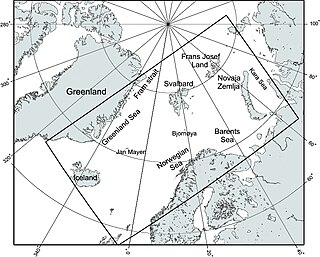
The Nordic Seas are located north of Iceland and south of Svalbard. They have also been defined as the region located north of the Greenland-Scotland Ridge and south of the Fram Strait-Spitsbergen-Norway intersection. Known to connect the North Pacific and the North Atlantic waters, this region is also known as having some of the densest waters, creating the densest region found in the North Atlantic Deep Water. The deepest waters of the Arctic Ocean are connected to the worlds other oceans through Nordic Seas and Fram Strait. There are three seas within the Nordic Sea: Greenland Sea, Norwegian Sea, and Iceland Sea. The Nordic Seas only make up about 0.75% of the World’s Oceans. This region is known as having diverse features in such a small topographic area, such as the mid oceanic ridge systems. Some locations have shallow shelves, while others have deep slopes and basins. This region, because of the atmosphere-ocean transfer of energy and gases, has varying seasonal climate. During the winter, sea ice is formed in the western and northern regions of the Nordic Seas, whereas during the summer months, the majority of the region remains free of ice.

References

  1. 1 2 Haugan, Peter M. (1999). "Structure and heat content of the West Spitsbergen Current". Polar Research. 18 (2): 183–188. Bibcode:1999PolRe..18..183H. doi:10.1111/j.1751-8369.1999.tb00291.x.
  2. 1 2 3 Bourke, R.H., A.M. Wiegel, and R.G. Paquette (1988). "The westward turning branch of the West Spitsbergen Current". Journal of Geophysical Research . 93 (C11): 14065–14077. Bibcode:1988JGR....9314065B. doi:10.1029/JC093iC11p14065.CS1 maint: multiple names: authors list (link)
  3. 1 2 3 Boyd, Timothy J.; D'asaro, Eric A. (1994). "Cooling of the West Spitsbergen Current: Wintertime Observations West of Svalbard". Journal of Geophysical Research. 99 (C11): 22597. Bibcode:1994JGR....9922597B. doi:10.1029/94JC01824.
  4. Manley, T. O. (1995). "Branching of Atlantic Water within the Greenland-Spitsbergen Passage: An estimate of recirculation". Journal of Geophysical Research. 100 (C10): 20627. Bibcode:1995JGR...10020627M. doi:10.1029/95JC01251.
  5. Saloranta, Tuomo M.; Svendsen, Harald (2001). "Across the Arctic front west of Spitsbergen: high-resolution CTD sections from 1998-2000". Polar Research. 20 (2): 177. Bibcode:2001PolRe..20..177S. doi:10.1111/j.1751-8369.2001.tb00054.x.
  6. 1 2 3 Dmitrenko, Igor A.; Polyakov, Igor V.; Kirillov, Sergey A.; Timokhov, Leonid A.; Frolov, Ivan E.; Sokolov, Vladimir T.; Simmons, Harper L.; Ivanov, Vladimir V.; Walsh, David (2008). "Toward a warmer Arctic Ocean: Spreading of the early 21st century Atlantic Water warm anomaly along the Eurasian Basin margins" (PDF). Journal of Geophysical Research. 113 (C5): C05023. Bibcode:2008JGRC..113.5023D. doi:10.1029/2007JC004158.
  7. Perkin, R.G.; Lewis, E.L. (1984). <1315:MITWSC>2.0.CO;2 "Mixing in the West Spitsbergen Current". Journal of Physical Oceanography. 14 (8): 1315. Bibcode:1984JPO....14.1315P. doi: 10.1175/1520-0485(1984)014<1315:MITWSC>2.0.CO;2 . ISSN   1520-0485.
  8. 1 2 Aagaard, K.; Foldvik, A.; Hillman, S. R. (1987). "The West Spitsbergen Current: Disposition and Water Mass Transformation". Journal of Geophysical Research. 92 (C4): 3778. Bibcode:1987JGR....92.3778A. doi:10.1029/JC092iC04p03778.
  9. Fahrbach, Eberhard; Meincke, Jens; Østerhus, Svein; Rohardt, Gerd; Schauer, Ursula; Tverberg, Vigdis; Verduin, Jennifer (2001). "Direct measurements of volume transports through Fram Strait" (PDF). Polar Research. 20 (2): 217. Bibcode:2001PolRe..20..217F. doi:10.1111/j.1751-8369.2001.tb00059.x.
  10. Westbrook, Graham K.; Thatcher, Kate E.; Rohling, Eelco J.; Piotrowski, Alexander M.; Pälike, Heiko; Osborne, Anne H.; Nisbet, Euan G.; Minshull, Tim A.; et al. (2009). "Escape of methane gas from the seabed along the West Spitsbergen continental margin" (PDF). Geophysical Research Letters. 36 (15): L15608. Bibcode:2009GeoRL..3615608W. doi:10.1029/2009GL039191.

See also