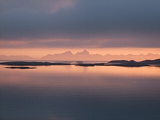
The Norwegian Sea is a marginal sea, grouped with either the Atlantic Ocean or the Arctic Ocean, northwest of Norway between the North Sea and the Greenland Sea, adjoining the Barents Sea to the northeast. In the southwest, it is separated from the Atlantic Ocean by a submarine ridge running between Iceland and the Faroe Islands. To the north, the Jan Mayen Ridge separates it from the Greenland Sea.

North Atlantic Deep Water (NADW) is a deep water mass formed in the North Atlantic Ocean. Thermohaline circulation of the world's oceans involves the flow of warm surface waters from the southern hemisphere into the North Atlantic. Water flowing northward becomes modified through evaporation and mixing with other water masses, leading to increased salinity. When this water reaches the North Atlantic, it cools and sinks through convection, due to its decreased temperature and increased salinity resulting in increased density. NADW is the outflow of this thick deep layer, which can be detected by its high salinity, high oxygen content, nutrient minima, high 14C/12C, and chlorofluorocarbons (CFCs).

The Barents Sea is a marginal sea of the Arctic Ocean, located off the northern coasts of Norway and Russia and divided between Norwegian and Russian territorial waters. It was known earlier among Russians as the Northern Sea, Pomorsky Sea or Murman Sea ; the current name of the sea is after the historical Dutch navigator Willem Barentsz.

The White Sea is a southern inlet of the Barents Sea located on the northwest coast of Russia. It is surrounded by Karelia to the west, the Kola Peninsula to the north, and the Kanin Peninsula to the northeast. The whole of the White Sea is under Russian sovereignty and considered to be part of the internal waters of Russia. Administratively, it is divided between the Arkhangelsk and Murmansk oblasts and the Republic of Karelia.

Thermohaline circulation (THC) is a part of the large-scale ocean circulation that is driven by global density gradients created by surface heat and freshwater fluxes. The adjective thermohaline derives from thermo- referring to temperature and -haline referring to salt content, factors which together determine the density of sea water. Wind-driven surface currents travel polewards from the equatorial Atlantic Ocean, cooling en route, and eventually sinking at high latitudes. This dense water then flows into the ocean basins. While the bulk of it upwells in the Southern Ocean, the oldest waters upwell in the North Pacific. Extensive mixing therefore takes place between the ocean basins, reducing differences between them and making the Earth's oceans a global system. The water in these circuits transport both energy and mass around the globe. As such, the state of the circulation has a large impact on the climate of the Earth.

The East Greenland Current (EGC) is a cold, low-salinity current that extends from Fram Strait (~80N) to Cape Farewell (~60N). The current is located off the eastern coast of Greenland along the Greenland continental margin. The current cuts through the Nordic Seas and through the Denmark Strait. The current is of major importance because it directly connects the Arctic to the Northern Atlantic, it is a major contributor to sea ice export out of the Arctic, and it is a major freshwater sink for the Arctic.

The Greenland Sea is a body of water that borders Greenland to the west, the Svalbard archipelago to the east, Fram Strait and the Arctic Ocean to the north, and the Norwegian Sea and Iceland to the south. The Greenland Sea is often defined as part of the Arctic Ocean, sometimes as part of the Atlantic Ocean. However, definitions of the Arctic Ocean and its seas tend to be imprecise or arbitrary. In general usage the term "Arctic Ocean" would exclude the Greenland Sea. In oceanographic studies the Greenland Sea is considered part of the Nordic Seas, along with the Norwegian Sea. The Nordic Seas are the main connection between the Arctic and Atlantic oceans and, as such, could be of great significance in a possible shutdown of thermohaline circulation. In oceanography the Arctic Ocean and Nordic Seas are often referred to collectively as the "Arctic Mediterranean Sea", a marginal sea of the Atlantic.
Bottom water is the lowermost water mass in a water body, by its bottom, with distinct characteristics, in terms of physics, chemistry, and ecology.

The Pechora Sea is an Arctic sea to the north-west of European Russia, forming the south-eastern portion of the Barents Sea. It is bordered to the west by Kolguyev Island; to the east by Vaygach Island's western coasts and the Yugorsky Peninsula; and to the north by the southern end of Novaya Zemlya.

The climate of the Arctic is characterized by long, cold winters and short, cool summers. There is a large amount of variability in climate across the Arctic, but all regions experience extremes of solar radiation in both summer and winter. Some parts of the Arctic are covered by ice year-round, and nearly all parts of the Arctic experience long periods with some form of ice on the surface.

The Arctic Ocean is the smallest and shallowest of the world's five oceanic divisions. It spans an area of approximately 14,060,000 km2 (5,430,000 sq mi) and is known as one of the coldest of oceans. The International Hydrographic Organization (IHO) recognizes it as an ocean, although some oceanographers call it the Arctic Mediterranean Sea. It has also been described as an estuary of the Atlantic Ocean. It is also seen as the northernmost part of the all-encompassing world ocean.

The Fram Strait is the passage between Greenland and Svalbard, located roughly between 77°N and 81°N latitudes and centered on the prime meridian. The Greenland and Norwegian Seas lie south of Fram Strait, while the Nansen Basin of the Arctic Ocean lies to the north. Fram Strait is noted for being the only deep connection between the Arctic Ocean and the World Oceans. The dominant oceanographic features of the region are the West Spitsbergen Current on the east side of the strait and the East Greenland Current on the west.
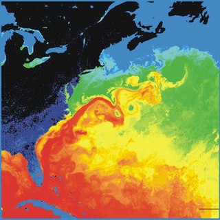
The Gulf Stream is a warm and swift Atlantic ocean current that originates in the Gulf of Mexico and flows through the Straits of Florida and up the eastern coastline of the United States, then veers east near 36°N latitude and moves toward Northwest Europe as the North Atlantic Current. The process of western intensification causes the Gulf Stream to be a northward-accelerating current off the east coast of North America. Around 40°0′N30°0′W, it splits in two, with the northern stream, the North Atlantic Drift, crossing to Northern Europe and the southern stream, the Canary Current, recirculating off West Africa.

The Beaufort Gyre is one of the two major ocean currents in the Arctic Ocean. It is roughly located north of the Alaskan and Canadian coast. In the past, Arctic sea-ice would circulate in the Beaufort gyre up to several years, leading to the formation of very thick multi-year sea-ice. Due to warming temperatures in the Arctic, the gyre has lost an extensive amount of ice, practically turning what used to be a nursery for sea-ice to mature and grow into the thickest and oldest ice of the Arctic Ocean into a "graveyard" for older ice.

The West Spitsbergen Current (WSC) is a warm, salty current that runs poleward just west of Spitsbergen,, in the Arctic Ocean. The WSC branches off the Norwegian Atlantic Current in the Norwegian Sea. The WSC is of importance because it drives warm and salty Atlantic Water into the interior Arctic. The warm and salty WSC flows north through the eastern side of Fram Strait, while the East Greenland Current (EGC) flows south through the western side of Fram Strait. The EGC is characterized by being very cold and low in salinity, but above all else it is a major exporter of Arctic sea ice. Thus, the EGC combined with the warm WSC makes the Fram Strait the northernmost ocean area having ice-free conditions throughout the year in all of the global ocean.
The Great Salinity Anomaly (GSA) originally referred to an event in the late 1960s to early 1970s where a large influx of freshwater from the Arctic Ocean led to a salinity anomaly in the northern North Atlantic Ocean, which affected the Atlantic meridional overturning circulation. Since then, the term "Great Salinity Anomaly" has been applied to successive occurrences of the same phenomenon, including the Great Salinity Anomaly of the 1980s and the Great Salinity Anomaly of the 1990s. The Great Salinity Anomalies were advective events, propagating to different sea basins and areas of the North Atlantic, and is on the decadal-scale for the anomalies in the 1970s, 1980s, and 1990s.
Brine rejection is a process that occurs when salty water freezes. The salts do not fit in the crystal structure of water ice, so the salt is expelled.
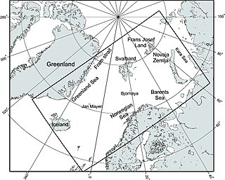
The Nordic Seas are located north of Iceland and south of Svalbard. They have also been defined as the region located north of the Greenland-Scotland Ridge and south of the Fram Strait-Spitsbergen-Norway intersection. Known to connect the North Pacific and the North Atlantic waters, this region is also known as having some of the densest waters, creating the densest region found in the North Atlantic Deep Water. The deepest waters of the Arctic Ocean are connected to the worlds other oceans through Nordic Seas and Fram Strait. There are three seas within the Nordic Sea: Greenland Sea, Norwegian Sea, and Iceland Sea. The Nordic Seas only make up about 0.75% of the World's Oceans. This region is known as having diverse features in such a small topographic area, such as the mid oceanic ridge systems. Some locations have shallow shelves, while others have deep slopes and basins. This region, because of the atmosphere-ocean transfer of energy and gases, has varying seasonal climate. During the winter, sea ice is formed in the western and northern regions of the Nordic Seas, whereas during the summer months, the majority of the region remains free of ice.
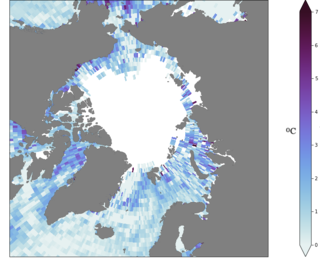
Atlantification is the increasing influence of Atlantic water in the Arctic. Warmer and saltier Atlantic water is extending its reach northward into the Arctic Ocean. The Arctic Ocean is becoming warmer and saltier and sea-ice is disappearing as a result. The process can be seen on the figure on the far right, where the sea surface temperature change in the past 50 years is shown, which is up to 5 degrees in some places. This change in the Arctic climate is most prominent in the Barents Sea, a shallow shelf sea north of Scandinavia, where sea-ice is disappearing faster than in any other Arctic region, impacting the local and global ecosystem.
Oceanic freshwater fluxes are defined as the transport of non saline water between the oceans and the other components of the Earth's system. These fluxes have an impact on the local ocean properties, as well as on the large scale circulation patterns.
