
The Antarctic Circumpolar Current (ACC) is an ocean current that flows clockwise from west to east around Antarctica. An alternative name for the ACC is the West Wind Drift. The ACC is the dominant circulation feature of the Southern Ocean and has a mean transport estimated at 100–150 Sverdrups, or possibly even higher, making it the largest ocean current. The current is circumpolar due to the lack of any landmass connecting with Antarctica and this keeps warm ocean waters away from Antarctica, enabling that continent to maintain its huge ice sheet.

Portugal is a coastal nation in western Europe, located at the western end of the Iberian Peninsula, bordering Spain. The Portuguese territory also includes a series of archipelagos in the Atlantic Ocean, which are strategic islands along the North Atlantic. The extreme south is not too far from the Strait of Gibraltar, leading to the Mediterranean Sea. In total, the country occupies an area of 92,090 square kilometres (35,560 sq mi) of which 91,470 square kilometres (35,320 sq mi) is land and 620 square kilometres (240 sq mi) water.

Downwelling is the process of accumulation and sinking of higher density material beneath lower density material, such as cold or saline water beneath warmer or fresher water or cold air beneath warm air. It is the sinking limb of a convection cell. Upwelling is the opposite process, and together, these two forces are responsible in the oceans for the thermohaline circulation. The sinking of the cold lithosphere at subduction zones is another example of downwelling in plate tectonics.

Upwelling is an oceanographic phenomenon that involves wind-driven motion of dense, cooler, and usually nutrient-rich water from deep water towards the ocean surface. It replaces the warmer and usually nutrient-depleted surface water. The nutrient-rich upwelled water stimulates the growth and reproduction of primary producers such as phytoplankton. The biomass of phytoplankton and the presence of cool water in those regions allow upwelling zones to be identified by cool sea surface temperatures (SST) and high concentrations of chlorophyll-a.

An ocean current is a continuous, directed movement of seawater generated by a number of forces acting upon the water, including wind, the Coriolis effect, breaking waves, cabbeling, and temperature and salinity differences. Depth contours, shoreline configurations, and interactions with other currents influence a current's direction and strength. Ocean currents are primarily horizontal water movements.
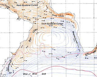
The Benguela Current is the broad, northward flowing ocean current that forms the eastern portion of the South Atlantic Ocean gyre. The current extends from roughly Cape Point in the south, to the position of the Angola-Benguela front in the north, at around 16°S. The current is driven by the prevailing south easterly trade winds. Inshore of the Benguela Current proper, the south easterly winds drive coastal upwelling, forming the Benguela Upwelling System. The cold, nutrient rich waters that upwell from around 200–300 m (656–984 ft) depth in turn fuel high rates of phytoplankton growth, and sustain the productive Benguela ecosystem.

The Canary Current is a wind-driven surface current that is part of the North Atlantic Gyre. This eastern boundary current branches south from the North Atlantic Current and flows southwest about as far as Senegal where it turns west and later joins the Atlantic North Equatorial Current. The current is named after the Canary Islands. The archipelago partially blocks the flow of the Canary Current.

The California Current is a cold water Pacific Ocean current that moves southward along the western coast of North America, beginning off southern British Columbia and ending off southern Baja California Sur. It is considered an Eastern boundary current due to the influence of the North American coastline on its course. It is also one of five major coastal currents affiliated with strong upwelling zones, the others being the Humboldt Current, the Canary Current, the Benguela Current, and the Somali Current. The California Current is part of the North Pacific Gyre, a large swirling current that occupies the northern basin of the Pacific.

Meroplankton are a wide variety of aquatic organisms which have both planktonic and benthic stages in their life cycles. Much of the meroplankton consists of larval stages of larger organism. Meroplankton can be contrasted with holoplankton, which are planktonic organisms that stay in the pelagic zone as plankton throughout their entire life cycle.

The KwaZulu-Natal sardine run of southern Africa occurs from May through July when billions of sardines – or more specifically the Southern African pilchard Sardinops sagax – spawn in the cool waters of the Agulhas Bank and move northward along the east coast of South Africa. Their sheer numbers create a feeding frenzy along the coastline. The run, containing millions of individual sardines, occurs when a current of cold water heads north from the Agulhas Bank up to Mozambique where it then leaves the coastline and goes further east into the Indian Ocean.
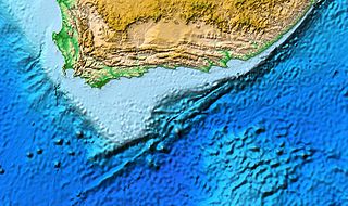
The Agulhas Bank is a broad, shallow part of the southern African continental shelf which extends up to 250 km (160 mi) south of Cape Agulhas before falling steeply to the abyssal plain.

The Norwegian Current is one of two dominant arctic inflows of water. It can be traced from near Shetland, north of Scotland, otherwise from the eastern North Sea at depths of up to 100 metres. It finally passes the Opening into the Barents Sea, a large outcrop of the Arctic Ocean. Compared to its partial source the North Atlantic Current it is colder and less salty; the other sources are the less saline North and Baltic seas and the Norwegian fjords and rivers. It is considerably warmer and saltier than the Arctic Ocean, which is freshened by precipitation and ice in and around it. Winter temperatures in the flow are typically between 2 and 5 °C — the co-parent North Atlantic flow, a heat remnant of its Gulf Stream chief contributor, exceeds 6 °C.
The Leeuwin Current is a warm ocean current which flows southwards near the western coast of Australia. It rounds Cape Leeuwin to enter the waters south of Australia where its influence extends as far as Tasmania.

Ekman transport is part of Ekman motion theory, first investigated in 1902 by Vagn Walfrid Ekman. Winds are the main source of energy for ocean circulation, and Ekman transport is a component of wind-driven ocean current. Ekman transport occurs when ocean surface waters are influenced by the friction force acting on them via the wind. As the wind blows it casts a friction force on the ocean surface that drags the upper 10-100m of the water column with it. However, due to the influence of the Coriolis effect, the ocean water moves at a 90° angle from the direction of the surface wind. The direction of transport is dependent on the hemisphere: in the northern hemisphere, transport occurs at 90° clockwise from wind direction, while in the southern hemisphere it occurs at 90° anticlockwise. This phenomenon was first noted by Fridtjof Nansen, who recorded that ice transport appeared to occur at an angle to the wind direction during his Arctic expedition during the 1890s. Ekman transport has significant impacts on the biogeochemical properties of the world's oceans. This is because it leads to upwelling and downwelling in order to obey mass conservation laws. Mass conservation, in reference to Ekman transfer, requires that any water displaced within an area must be replenished. This can be done by either Ekman suction or Ekman pumping depending on wind patterns.
In oceanography, a front is a boundary between two distinct water masses. The formation of fronts depends on multiple physical processes and small differences in these lead to a wide range of front types. They can be as narrow as a few hundreds of metres and as wide as several tens of kilometres. While most fronts form and dissipate relatively quickly, some can persist for long periods of time.

The Table Mountain National Park Marine Protected Area is an inshore marine protected area around the Cape Peninsula, in the vicinity of Cape Town, South Africa. It was proclaimed in Government Gazette No. 26431 of 4 June 2004 in terms of the Marine Living Resources Act, 18 of 1998.

Heceta Bank is a rocky bank located 55 kilometers (km) off the Oregon coast near Florence, centered on approximately 44°N, 125°W, and is roughly 29 km long and upwards of 13 km wide. Heceta Bank is an area of ecological and oceanographic importance. The unique bathymetric features and seasonal circulation within the bank provides habitat for a diversity of economically-important fish species.

The Marine biodiversity of South Africa is the variety of living organisms that live in the seas off the coast of South Africa. It includes genetic, species and ecosystems biodiversity in a range of habitats spread over a range of ecologically varied regions, influenced by the geomorphology of the seabed and circulation of major and local water masses, which distribute both living organisms and nutrients in complex and time-variable patterns.
A Wind generated current is a flow in a body of water that is generated by wind friction on its surface. Wind can generate surface currents on water bodies of any size. The depth and strength of the current depend on the wind strength and duration, and on friction and viscosity losses, but are limited to about 400 m depth by the mechanism, and to lesser depths where the water is shallower. The direction of flow is influenced by the Coriolis effect, and is offset to the right of the wind direction in the Northern Hemisphere, and to the left in the Southern Hemisphere. A wind current can induce secondary water flow in the form of upwelling and downwelling, geostrophic flow, and western boundary currents.

The Southern Ocean overturning circulation is a two-cell system in the Southern Ocean that connects different water basins within the global circulation. It is driven by upwelling and downwelling, which are a result of the physical ocean processes that are influenced by freshwater fluxes and wind stress. The global ocean circulation is an essential mechanism in our global climate system due to its influence on the global heat, fresh water and carbon budgets. The upwelling in the upper cell is associated with mid-deep water that is brought to the surface, whereas the upwelling in the lower cell is linked to the fresh and abyssal waters around Antarctica. Around 27 ± 7 Sverdrup (Sv) of deep water wells up to the surface in the Southern Ocean. This upwelled water is partly transformed to lighter water and denser water, respectively 22 ± 4 Sv and 5 ± 5 Sv. The densities of these waters change due to heat and buoyancy fluxes which result in upwelling in the upper cell and downwelling in the lower cell.
