
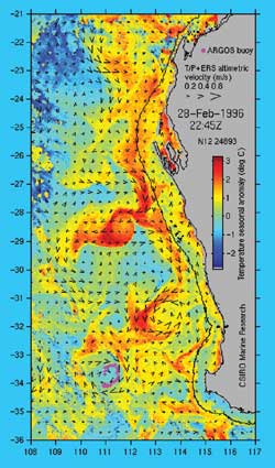
The West Australian Current (or the Western Australian Current) is a cool surface current of the Southern Ocean and Southern Indian Ocean.
The West Australian Current (or the Western Australian Current) is a cool surface current of the Southern Ocean and Southern Indian Ocean.
It starts as the Southern Indian Ocean Current, a part of the larger Antarctic Circumpolar Current (also known as the West Wind Drift [1] ). As the current approaches Western Australia, it turns north, parallel to the western coast of Australia, and becomes the West Australian Current.
The current is mainly seasonal, being weaker in winter and stronger in summer, and is affected by the winds in that area. [2] [3] [4]
In addition to the West Australian Current flowing on the Western Australian Coast, the Leeuwin Current [5] and Southern Australian Countercurrent, also flow along this coast, with the former flowing in the opposite direction. These three currents together contribute greatly to the rainfall and climate in the southwest region of Western Australia. [6] [7]

The Antarctic Circumpolar Current (ACC) is an ocean current that flows clockwise from west to east around Antarctica. An alternative name for the ACC is the West Wind Drift. The ACC is the dominant circulation feature of the Southern Ocean and has a mean transport estimated at 100–150 Sverdrups, or possibly even higher, making it the largest ocean current. The current is circumpolar due to the lack of any landmass connecting with Antarctica and this keeps warm ocean waters away from Antarctica, enabling that continent to maintain its huge ice sheet.

An ocean current is a continuous, directed movement of seawater generated by a number of forces acting upon the water, including wind, the Coriolis effect, breaking waves, cabbeling, and temperature and salinity differences. Depth contours, shoreline configurations, and interactions with other currents influence a current's direction and strength. Ocean currents are primarily horizontal water movements.

In oceanography, a gyre is any large system of circulating ocean surface currents, particularly those involved with large wind movements. Gyres are caused by the Coriolis effect; planetary vorticity, horizontal friction and vertical friction determine the circulatory patterns from the wind stress curl (torque).

The Antarctic oscillation, also known as the Southern Annular Mode (SAM), is a low-frequency mode of atmospheric variability of the southern hemisphere that is defined as a belt of strong westerly winds or low pressure surrounding Antarctica which moves north or south as its mode of variability.
The term Southern Australia is generally considered to refer to the states and territories of Australia of New South Wales, Victoria, Tasmania, the Australian Capital Territory and South Australia. The part of Western Australia south of latitude 26° south — a definition widely used in law and state government policy — is also usually included.
The Leeuwin Current is a warm ocean current which flows southwards near the western coast of Australia. It rounds Cape Leeuwin to enter the waters south of Australia where its influence extends as far as Tasmania.

Australia's climate is governed mostly by its size and by the hot, sinking air of the subtropical high pressure belt. This moves north-west and north-east with the seasons. The climate is variable, with frequent droughts lasting several seasons, thought to be caused in part by the El Niño-Southern Oscillation. Australia has a wide variety of climates due to its large geographical size. The largest part of Australia is desert or semi-arid. Only the south-east and south-west corners have a temperate climate and moderately fertile soil. The northern part of the country has a tropical climate, varying between grasslands and desert. Australia holds many heat-related records: the continent has the hottest extended region year-round, the areas with the hottest summer climate, and the highest sunshine duration.
The following outline is provided as an overview of and introduction to Oceanography.

The Weddell Gyre is one of the two gyres that exist within the Southern Ocean. The gyre is formed by interactions between the Antarctic Circumpolar Current (ACC) and the Antarctic Continental Shelf. The gyre is located in the Weddell Sea, and rotates clockwise. South of the ACC and spreading northeast from the Antarctic Peninsula, the gyre is an extended large cyclone. Where the northeastern end ends at 30°E, which is marked by the southward turn of the ACC, the northern part of the gyre spreads over the Southern Scotia Sea and goes northward to the South Sandwich Arc. Axis of the gyre is over the southern flanks of the South Scotia, America-Antarctic, and Southwest Indian Ridges. In the southern part of the gyre, the westward return flow is about 66 sverdrup (Sv), while in the northern rim current, there is an eastward flow of 61 Sv.
The south coast of Western Australia comprises the Western Australian coastline from Cape Leeuwin to Eucla. This is a distance of approximately 1,600 kilometres (1,000 mi), fronting the Great Australian Bight and the Southern Ocean.

The 1981–82 Australian region cyclone season was an average season. It officially started on 1 November 1981, and officially ended on 30 April 1982.

The 2019–20 Australian region cyclone season was a below average tropical cyclone season for the waters surrounding Australia between longitudes 90°E and 160°E. The season officially began on 1 November 2019 and ended on 30 April 2020; however, tropical cyclones can form at any time of year, as evidenced by Tropical Cyclone Mangga during May 2020. As such, any system existing between 1 July 2019 and 30 June 2020 would count towards the season total. The season featured the region's second-latest start on record, with the formation of the first tropical low only occurring on 4 January 2020. A total of eight tropical cyclones formed during the season, which represents the region's least active season since the 2016–17 season. Three systems intensified further into severe tropical cyclones, and three systems made landfall within the region at tropical cyclone intensity. A total of 28 fatalities were caused, either directly or indirectly, as a result of impacts from the season's systems. Cyclone Ferdinand was the strongest of the season reaching Category 4 in late February 2020. However, it was the second-strongest storm, Cyclone Damien, that was the most damaging. Damien was the strongest tropical cyclone to strike Western Australia's Pilbara Region since Cyclone Christine in 2013, making landfall directly over the town of Dampier.

The 2020–21 Australian region cyclone season was a below average but very deadly season when most tropical cyclones formed in the Southern Indian Ocean and Pacific Oceans between 90°E and 160°E. It produced 8 tropical cyclones with 3 strengthening into severe tropical cyclones. However, it featured the region's third-deadliest cyclone on record—Cyclone Seroja, which brought severe floods and landslides to southern Indonesia and East Timor. The season officially began on 1 November 2020 and started with the formation of Tropical Low 01U on 24 November within the basin, which would later become Tropical Storm Bongoyo in the South-West Indian Ocean, and ended with the dissipation of a tropical low on 24 April, 6 days before the season ended on 30 April. However, a tropical cyclone could form at any time between 1 July 2020 and 30 June 2021 and would count towards the season total. During the season, tropical cyclones were officially monitored by one of the three tropical cyclone warning centres (TCWCs) for the region which are operated by the Australian Bureau of Meteorology, National Weather Service of Papua New Guinea and the Indonesian Agency for Meteorology, Climatology and Geophysics. The United States Joint Typhoon Warning Center (JTWC) and other national meteorological services including Météo-France also monitored the basin during the season.

The Pilbara Coast is the coastline of Western Australia's Pilbara region. It is often referred to as the North West Coast of Western Australia.
Charitha Pattiaratchi is a Winthrop Professor of coastal oceanography at the University of Western Australia. He leads the UWA Coastal Oceanography Group. and the IMOS Australian National Facility for Ocean Gliders. He has played an active role in research related in understanding climate change effects in the regions of coastal Western Australia and specifically in terms wind and wave climate, ocean currents, coastal flooding, sea level variability and beach stability. The research programs he has developed involves ocean observation integration, numerical modelling and synthesis to define the role of physical processes in pathways of water and sediment weather and climate and ecosystem in the coastal ocean and the adjacent deep ocean.

Tropical Cyclone Imogen was a weak but damaging tropical cyclone that affected parts of northern Queensland. The sixth tropical low, and the first cyclone of the 2020–21 Australian region cyclone season, Imogen originated from a tropical low that formed in the western Gulf of Carpentaria.
Moninya Roughan is a professor of Oceanography at the University of New South Wales Australia,. Roughan is the head of the Coastal and Regional Oceanography Lab and is an authority on the oceanography of the East Australian Current. She has led major projects for industry, government, the Australian Research Council and the New Zealand Ministry of Business Innovation and Employment. She has held leadership roles in Australia's Integrated Marine Observing System since 2007.

Effects of the El Niño–Southern Oscillation in Australia is present across most of Australia, particularly the north and the east, and is one of the main climate drivers of the country. Associated with seasonal abnormality in many areas in the world, Australia is one of the continents most affected and experiences extensive droughts alongside considerable wet periods that cause major floods. There exist three phases — El Niño, La Niña, and Neutral, which help to account for the different states of ENSO. Since 1900, there have been 27 El Niño and 18 La Niña events in Australia. The events usually last for 9 to 12 months, but some can persist for two years, though the ENSO cycle generally operates over a time period from one to eight years.
2022 was an extremely wet year for Australia, coming out of a back-to-back La Niña in the summer of 2021-22, a Negative Indian Ocean Dipole developing over the winter and a third back-to-back La Niña in the spring of 2022.
Ocean currents and gyres | |||||||||||
|---|---|---|---|---|---|---|---|---|---|---|---|
| Currents |
| ||||||||||
| Gyres |
| ||||||||||
| Related | |||||||||||