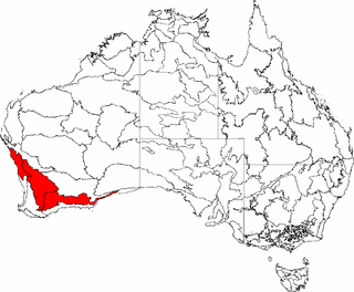
Desert and xeric shrublands lie to the north and east across the centre of Australia, separating Southwest Australia from the other Mediterranean and humid-climate regions of the continent.[citation needed]
Climate
The region has a wet-winter, dry-summer Mediterranean climate, one of five such regions in the world. During the winter months, westerly winds bring cool weather, clouds, and rainfall to Southwest Australia. In the summer months, the lower-latitude anticyclonic belt, with generally dry easterly winds, moves southwards, increasing temperatures and decreasing rainfall. Tropical cyclones, off the shore of northern Western Australia during the December-to-March northern wet season, occasionally reach as far south as Perth before moving inland, bringing floods and damaging winds to the west coast and rain to the dry interior.[5]
Rainfall generally decreases from south to north, and with distance from the coast. The highest rainfall is typically in the Karri Forest Region between Pemberton and Walpole, up to 1,400 mm (55 inches) annually.[5]
The region has been experiencing the effects of human induced climate change. Average annual rainfall has declined as much as 20% since the 1970s, declining by 10-20 millimetres each decade. Summertime maximum temperatures have increased by 0.1º to 0.3º C per decade, and the average number of days per year over 40º C in Perth has doubled over the last century.[6] Lower rainfall and higher temperatures have reduced stream flow and inflow into drinking water and irrigation catchments since the 1960s. The summer of 2021/22 was the hottest on record.[citation needed]
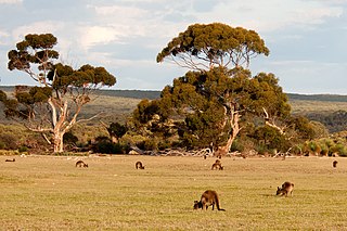
Vegetation in the region is mainly woody, including forests, woodlands, shrublands, and heathlands, but no grasslands. Predominant vegetation types are Eucalyptus woodlands, eucalyptus-dominated mallee shrublands, and kwongan shrublands and heathlands, which correspond to the chaparral, matorral, maquis, and fynbos shrublands found in other Mediterranean-type regions. The region has generally nutrient-poor sandy or lateritic soils, which has encouraged rich speciation of plants adapted to specific ecological niches. The region hosts a great diversity of endemic species, notably among the protea family (Proteaceae).[citation needed]
The transitional Coolgardie, Hampton, and Yalgoo bioregions are generally drier than the rest of the Southwest. They considered part of Southwest Australia by the WWF, but are considered part of the Central Australian or Eremaean Region by the Western Australian Herbarium.[10]
Southwest Australia has several permanent rivers and streams, including the Swan–Avon system, the Blackwood River, and other short rivers. The perennial rivers drain from the interior plateau and Darling Range across the coastal plain. Their flow is strongly seasonal, corresponding to the Southwest's wet winter–dry summer weather pattern. The perennial streams extend from east of Esperance on the south coast to the Arrowsmith River north of Perth, most often in areas with 700 mm or more of annual rainfall.[11]
Arid regions separate Southwest Australia's freshwater habitats from Australia's other year-round rivers. As with its terrestrial flora, Southwest Australia's Mediterranean climate and biogeographic isolation has given rise to a distinct freshwater ecoregion with many endemic species.[11]
There are fifteen freshwater fish species, including nine exclusively freshwater species, three estuarine species adapted to brackish water, and three diadromous species that spend part of their life-cycle in the sea. The exclusively freshwater species are endemic to Southwest Australia, as are two estuarine species. The salamanderfish (Lepidogalaxias salamandroides) is the sole species in the endemic family Lepidogalaxiidae. Salamanderfish can aestivate during the summer months, an adaptation to the region's dry summers. Other endemic species are the nightfish (Bostockia porosa), western mud minnow (Galaxiella munda), black-stripe minnow (Galaxiella nigrostriata), Balston’s pygmy perch (Nannatherina balstoni),[11]western pygmy perch (Nannoperca vittata), and western galaxias (Galaxias occidentalis).
Southwest Australian varieties of the diadromous common galaxias (Galaxias maculatus) and spotted galaxias (Galaxias truttaceus) have adapted so they can live their life-cycle and reproduce in fresh water.[11]
The first evidence of human habitation of the region was 50,000 years ago at Devil's Lair by ancestors of today's Aboriginal people.[12]
Aboriginal populations were generally denser on the coastal plain and along the coastal forest edge, and in the interior woodlands and shrublands, particularly near permanent streams and river estuaries. Population was sparse in the forested areas of the south. Offshore islands were likely uninhabited.[12]
The Aboriginal inhabitants deliberately set fires to manage the land and vegetation. Evidence from lake and estuarine sediments and firsthand accounts suggest that fire intervals in well-settled areas were frequent – from one to ten years – compared to unoccupied forests and offshore islands, where fire intervals were 30 to 100 or more years. Frequent burning reduced tree cover and encouraged the growth of grasses, herbs, and low shrubs, fostering open woodlands and savannas and limiting areas of dense forest and thicket.[12]
Noongar peoples inhabited the western and southern portions of the region. The Noongar comprised 14 groups, which spoke distinct but mutually-intelligible languages.
The Nyoongar seasonal calendar includes six different seasons in a yearly cycle. These are Birak, Bunuru, Djeran, Makuru, Djilba and Kambarang. Each of the six seasons represents and explains the seasonal changes seen annually. The flowering of many different plants, the hibernation of reptiles and the moulting of swans are all helpful indicators that the seasons are changing.
The first permanent European settlement in the region was in 1826 near present-day Albany. European settlers mostly dispossessed the Aboriginal inhabitants, and established extensive agriculture, including wheat, barley, canola, lupins, and oats. They also introduced sheep and cattle to the region. European settlement also changed the fire regime established by the Aboriginal inhabitants of the land.
Protected areas
109,445 km2, or 22.13%, of Southwest Australia's land area is in protected areas.[13][14][15][16][17][18]
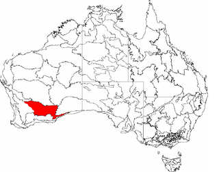
Esperance Plains, also known as Eyre Botanical District, is a biogeographic region in southern Western Australia on the south coast between the Avon Wheatbelt and Hampton bioregions, and bordered to the north by the Mallee region. It is a plain punctuated by granite and quartz outcrops and ranges, with a semi-arid Mediterranean climate and vegetation consisting mostly of mallee-heath and proteaceous scrub. About half of the region has been cleared for intensive agriculture. Recognised as a bioregion under the Interim Biogeographic Regionalisation for Australia (IBRA), it was first defined by John Stanley Beard in 1980.
Mallee, also known as Roe Botanical District, is a biogeographic region in southern Western Australia. Located between the Esperance Plains, Avon Wheatbelt and Coolgardie bioregions, it has a low, gently undulating topography, a semi-arid mediterranean climate, and extensive Eucalyptus mallee vegetation. It has an area of 73,975.59 square kilometres (28,562.13 sq mi). About half of the region has been cleared for intensive agriculture. Recognised as a region under the Interim Biogeographic Regionalisation for Australia (IBRA), it was first defined by John Stanley Beard in 1980.
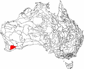
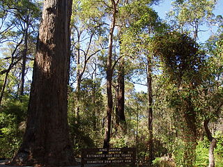
Warren, also known as Karri Forest Region and the Jarrah-Karri forest and shrublands ecoregion, is a biogeographic region in southern Western Australia. Located in the southwest corner of Western Australia between Cape Naturaliste and Albany, it is bordered to the north and east by the Jarrah Forest region. Its defining characteristic is an extensive tall forest of Eucalyptus diversicolor (karri). This occurs on dissected, hilly ground, with a moderately wet climate. Karri is a valuable timber and much of the karri forest has been logged over, but less than a third has been cleared for agriculture. Recognised as a region under the Interim Biogeographic Regionalisation for Australia (IBRA), and as a terrestrial ecoregion by the World Wide Fund for Nature, it was first defined by Ludwig Diels in 1906.
Esperance mallee is an ecoregion on the south coast of Western Australia, a coastal strip where the predominant vegetation consists of short eucalyptus trees and shrubs.
The Transitional Rainfall Zone (TRZ) is one of three biogeographic zones into which south-west Western Australia is divided, the others being the High Rainfall Zone and the Low Rainfall Zone. The TRZ is recognised as having a much higher diversity of rare and endemic plant species than the other Zones.
Western Mallee is an Interim Biogeographic Regionalisation for Australia (IBRA) subregion in southern Western Australia. It is a sparsely populated subregion with an area of about 47,000 square kilometres, roughly centred on the town of Newdegate. Largely cleared for intensive agriculture, it still retains patches of native vegetation, but these are under environmental stress from threats such as rising salinity, and are poorly managed.
Eastern Mallee is an Interim Biogeographic Regionalisation for Australia (IBRA) subregion in southern Western Australia.
Coolgardie is an Australian bioregion consisting of an area of low hills and plains of infertile sandy soil in Western Australia. It has an area of 129,122.09 square kilometres (49,854.32 sq mi). It includes much of the Great Western Woodlands.
Hampton is an interim Australian bioregion located in southeastern coastal Western Australia, with a small portion (4%) extending into adjacent South Australia. It has an area of 1,088,198 hectares. The Hampton bioregion is part of the Coolgardie woodlands ecoregion.
Jarrah Forest, also known as the Southwest Australia woodlands, is an interim Australian bioregion and ecoregion located in the south west of Western Australia. The name of the bioregion refers to the region's dominant plant community, jarrah forest – a tall, open forest in which the dominant overstory tree is jarrah.
Yalgoo is an interim Australian bioregion located in Western Australia. It has an area of 5,087,577 hectares. The bioregion, together with the Avon Wheatbelt and Geraldton Sandplains bioregions, is part of the larger Southwest Australia savanna ecoregion as classified by the World Wildlife Fund.
Western Australia occupies nearly one third of the Australian continent. Due to the size and the isolation of the state, considerable emphasis has been made of these features; it is the second largest administrative territory in the world, after Yakutia in Russia, despite the fact that Australia is only the sixth largest country in the world by area, and no other regional administrative jurisdiction in the world occupies such a high percentage of a continental land mass. It is also the only first level administrative subdivision to occupy the entire continental coastline in one cardinal direction.
The Coolgardie woodlands is an ecoregion in southern Western Australia. The predominant vegetation is woodlands and mallee scrub. The ecoregion is a transitional zone between the Mediterranean-climate forests, woodlands, and shrublands of Southwest Australia and the deserts and dry scrublands of the Australian interior.
The Mount Lofty woodlands, or the Peppermint Box Grassy Woodland of South Australia, is an ecoregion in South Australia, which includes woodlands, shrublands, and grasslands in the Mount Lofty Ranges, Fleurieu Peninsula, and Kangaroo Island.
The Naracoorte woodlands is an ecoregion in southern Australia. It covers the Naracoorte coastal plain in southeastern South Australia and southwestern Victoria. It is coterminous with the Naracoorte Coastal Plain IBRA region. Only 10% of the ecoregion's area still has its original vegetation; most has been converted to agriculture and pasture.
The Southwest Australia savanna is an ecoregion in Western Australia.
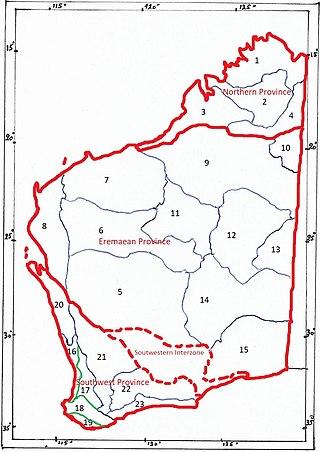
The botanical provinces of Western Australia (or Beard's Provinces) delineate "natural" phytogeographic regions of WA, based on climate and types of vegetation. John Stanley Beard, in "Plant Life of Western Australia" (p. 29-37) gives a short history of the various mappings.
Opercularia vaginata (dogweed) is a species of plant within the genus Opercularia, in the family Rubiaceae. It is endemic to the southwest of Western Australia.
Gawler is an interim Australian bioregion located in South Australia. It has an area of 12,002,883 hectares. Gawler bioregion is part of the Tirari–Sturt stony desert ecoregion.
↑ Burbidge, Andrew (1 February 2010), "Global hotspot under stress: while the south-west corner of Western Australia is recognised as a global biodiversity hotspot, its unique ecosystems have suffered land clearing, introduced pests and weeds, a changed fire regime, loss of water and salinisation. climate change may tip the balance for some species, unless effective action is taken.(Focus)", Ecos, CSIRO Publishing (153): 18(2), ISSN0311-4546
↑ Lambers, H., ed. (2014), Plant life on the sandplains in southwest Australia: a global biodiversity hotspot: kwongan matters, Crawley, Western Australia UWA Publishing, ISBN978-1-74258-564-2
↑ Cook, Lyn G; Hardy, Nate B; Crisp, Michael D (2015), "Three explanations for biodiversity hotspots: small range size, geographical overlap and time for species accumulation. An Australian case study", New Phytologist, Wiley Subscription Services, Inc (published 1 July 2015), 207 (2): 390–400, doi:10.1111/nph.13199, ISSN0028-646X, PMID25442328
1 2 3 4 Unmack, Peter. "Southwestern Australia". Freshwater Ecoregions of the World. Accessed 17 June 2020.
1 2 3 "Hassell, Cleve W., and Dodson, John R. (2003). "The fire history of south-west Western Australia prior to European settlement in 1826-1829". in Fire in ecosystems of south-west Western Australia:Impacts and management. Ian Abbott and Neil Burrows, eds. Backhuys Publishers, 2003, pp. 71–85.
1 2 "Coolgardie woodlands". DOPA Explorer. Accessed 29 April 2022.
1 2 "Esperance mallee". DOPA Explorer. Accessed 29 April 2022.
1 2 "Jarrah-Karri forest and shrublands". DOPA Explorer. Accessed 29 April 2022.
1 2 "Southwest Australia savanna". DOPA Explorer. Accessed 29 April 2022.
1 2 "Southwest Australia woodlands". DOPA Explorer. Accessed 29 April 2022.
1 2 "Swan Coastal Plain scrub and woodlands". DOPA Explorer. Accessed 29 April 2022.
This page is based on this Wikipedia article Text is available under the CC BY-SA 4.0 license; additional terms may apply. Images, videos and audio are available under their respective licenses.